Lan Ucha Ty’n y Wern (SN 996 423)
There has been a Summit Relocation to a hill that
is listed in the Y Trichant – The 300m
Hills of Wales and the Y Pedwarau –
The 400m Hills of Wales, with the summit height, bwlch height and their
locations, the drop and status of the hill derived from LIDAR analysis initially
conducted by Aled Williams and subsequently by Myrddyn Phillips.
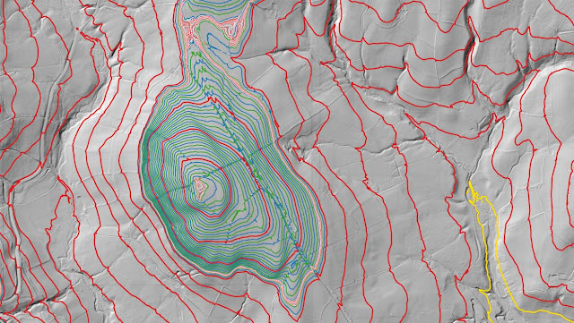%20-%20LIDAR%20hill%201.jpg) |
| LIDAR image of Lan Ucha Ty'n y Wern (SN 996 423) |
The criteria for the lists this
summit relocation affects are:
 |
| Y Trichant - The 300m Hills of Wales by Myrddyn Phillips |
 |
| Y Pedwarau - The 400m Hills of Wales by Myrddyn Phillips and Aled Williams |
The name the hill is now listed by is Lan Ucha Ty’n
y Wern and this was derived from the Tithe map, and it is adjoined to the Mynydd
Epynt group of hills, which are situated in the central
part of South Wales (Region B, Sub-Region B1), and it is positioned with the B4519 road to its
north-east and a minor road to its south, and has the small community of Capel
Uchaf (Upper Chapel) towards the south-east.
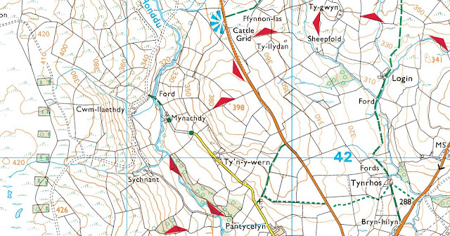%20-%201%2025000.jpg) |
| Extract from the Ordnance Survey 1:25,000 Explorer map |
However, it was not until LIDAR became available
that the details for this hill could be accurately re-assessed. The LIDAR (Light Detection & Ranging)
technique produced highly accurate height data that is now freely available for
much of England and Wales.
LIDAR analysis gives the highest ground on this
hill as 396.9m positioned at SN 99625 42340.
However, this is a part of a raised field boundary and protocols dictate
that as this is deemed a relatively recent man-made construct such ground is discounted
from the height of a hill.
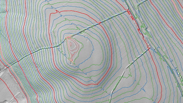%20-%20LIDAR%20summit%202.jpg) |
| LIDAR summit image of Lan Ucha Ty'n y Wern (SN 996 423) |
The height produced by LIDAR analysis to the natural
summit of this hill is 396.7m positioned at SN 99632 42324, and this position
in relation to raised field boundary comes within the parameters of the Summit Relocations
used within this page heading, these parameters are:
The term Summit Relocations applies when the high
point of the hill is found to be positioned; in a different field, to a
different feature such as in a conifer plantation, within a different map contour, to a
different point where a number of potential summit positions are within close
proximity, when natural ground or the natural and intact summit of a hill is
confirmed compared to a higher point such as a raised field boundary or covered
reservoir that is considered a relatively recent man-made construct, or a
relocation of approximately 100 metres or more in distance from either the
position of a map spot height or from where the summit of the hill was
previously thought to exist.
Therefore, the summit height produced by LIDAR
analysis is 396.7m and this is positioned at SN 99632 42324, this position is close
to where the 398m spot height appears on the Ordnance Survey 1:25,000 Explorer
map, and is approximately 16 metres south-eastward from where the high point of
the raised field boundary is positioned.
The full details for the hill are:
Group: Mynydd Epynt
Name: Lan Ucha Ty’n y Wern
OS 1:50,000 map: 147, 160
Summit Height: 396.7m (LIDAR)
Summit Grid Reference
(New Position): SN 99632 42324 (LIDAR)
Bwlch Height: 362.65m (LIDAR)
Bwlch Grid
Reference: SN 99601 42833 (LIDAR)
Drop: 34.1m (LIDAR)
Myrddyn Phillips and
Aled Williams (July 2024)
%20-%20LIDAR%20hill%201.jpg)


%20-%201%2025000.jpg)
%20-%20LIDAR%20summit%202.jpg)
No comments:
Post a Comment