Carreg Rhoson (SM 672 256) – Dominant deletion
There has been a deletion from the list of the Y Trechol – The Dominant Hills of Wales, with the summit height and its location, the drop, dominance and status of the hill derived from detail on the DataMapWales.
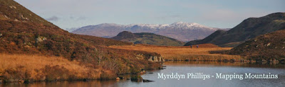
%20-%20hill%20(island%20on%20right).JPG) |
| Carreg Rhoson (SM 672 256) is positioned on the right of this photograph |
The criteria for the list that this deletion
applies to are:
Y Trechol - The Dominant Hills of
Wales - Welsh P30 hills whose prominence
equal or exceed half that of their absolute height. With the
criteria for Lesser Dominant status being those additional Welsh P30 hills whose
prominence is between one third and half that of their absolute height. The list is authored by Myrddyn Phillips with
the Introduction to the start of the Mapping Mountains publication of this list
appearing on the 3rd December 2015, and the list is now available inits entirety on Mapping Mountains in Google Doc format.
 |
| Y Trechol - The Dominant Hills of Wales by Myrddyn Phillips |
The name the hill is listed by is Carreg Rhoson, and it is adjoined to the Garn Fawr
group of hills which are situated in the
south-western part of South Wales (Region B, Sub-Region B1), and it forms a part of the islet chain known as
Carreg Rhoson, and it is positioned to the west of the Pembrokeshire coast,
with the small city of Tyddewi (St David’s) towards the east.
When the original 30-99m height band of Welsh P30 hills were published on Geoff Crowder’s v-g.me website, this hill was not included
in the main P30 list as the small uppermost 30m ring contour that appears on
the Ordnance Survey 1:25,000 Explorer map had been missed.
%20-%201%2025000.jpg) |
| Extract from the Ordnance Survey 1:25,000 Explorer map |
After the sub list was standardised, and
interpolated heights and drop values also included the details for this hill
were re-evaluated and it was listed with an estimated c 30m summit height,
based on interpolation of its uppermost 30m ring contour. As this hill is the high point of an island
it was also listed with an estimated c 30m drop, which was sufficient for it to
be classified as a Dominant hill with 100.00% dominance.
However, it was not until the DataMapWales became
available online that the details of this hill could be checked against a
product viewed as being more accurate than the contouring on the contemporary
Ordnance Survey 1:25,000 map. This
mapping has a 28m spot height for this hill and this is similar to the 27.42m
summit height produced by the surface analysis programme developed by Joe Nuttall (JNSA) that uses the OS Terrain product where LIDAR coverage is not
available.
%20-%20DataMapWales.jpg) |
| Extract from the DataMapWales |
Therefore, the deletion of this hill from Dominant
status is due to detail on the DataMapWales, resulting in a 28m summit height,
and as this hill is also an island the drop value is also 28m, which is
insufficient for Dominant status.
The full details for the hill are:
Group: Garn Fawr
Name: Carreg Rhoson
OS 1:50,000 map: 157
Summit Height: 28m (spot
height)
Summit Grid Reference:
SM
67228 25658 (JNSA)
Bwlch Height: N/A (island)
Bwlch Grid Reference: N/A
(island)
Drop: 28m (spot height)
Myrddyn Phillips (June 2024)
No comments:
Post a Comment