Foel Ganol (SH 687 715)
There has been a Significant Height Revision to a hill that is listed in the 500m Twmpau and the Welsh Highlands – Uchafion Cymru, with the summit height, bwlch height and their locations, the drop and status of the hill derived from LIDAR analysis conducted by Aled Williams.
%20-%20LIDAR%20hill%203.jpg) |
| LIDAR image of Foel Ganol (SH 687 715) |
The criteria for the two listings that this height
revision applies to are:
500m Twmpau – Welsh hills at or above
500m and below 600m in height that have 30m minimum drop, with an accompanying
sub category entitled the 500m Sub-Twmpau consisting of all Welsh hills at or
above 500m and below 600m in height that have 20m or more and below 30m of drop. With the word Twmpau being an acronym
standing for thirty welsh metre prominences and upward. The list is authored by Myrddyn Phillips and is published on Mapping Mountains in Google Doc format.
 |
| 500m Twmpau by Myrddyn Phillips |
Welsh Highlands – Uchafion
Cymru – Welsh hills at or above 500m in height
with 15m minimum drop, with an accompanying sub list entitled the Welsh
Highland Subs, the criteria for which is all Welsh hills at or above 500m in
height with 10m or more and below 15m of drop.
This list is authored by Myrddyn Phillips and Aled Williams with the Introduction to the list published on Mapping Mountains in November 2015 and
the latest update relating to the list published on Mapping Mountains in January 2023.
 |
| Welsh Highlands - Uchafion Cymru by Aled Williams and Myrddyn Phillips |
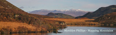
The name the hill is listed by is Foel Ganol and it is adjoined to the Carnedd
Llywelyn group of hills,
which are situated in the north-western part of North Wales (Region A,
Sub-Region A1), and it is positioned with the A55 road to its north-west and a
minor road to its west, and has the town of Llanfairfechan towards the north.
When the list of Welsh 500m P15s that later became
known as the Welsh Highlands – Uchafion
Cymru was first compiled, this hill was listed with 40m of drop, based on
the 536m summit spot height and the 496m bwlch spot height that appear on the
Ordnance Survey 1:25,000 Explorer map.
%20-%201%2025000.jpg) |
| Extract from the Ordnance Survey 1:25,000 Explorer map |
However, it was not until LIDAR became available
that the details for this hill could be accurately re-assessed. The LIDAR (Light Detection & Ranging)
technique produced highly accurate height data that is now freely available for
much of England and Wales.
%20-%20LIDAR%20hill%205.jpg) |
| LIDAR summit image of Foel Ganol (SH 687 715) |
LIDAR analysis gives the summit of this hill as 533.1m
positioned at SH 68797 71588, and when compared to its originally listed summit
height of 536m this comes within the parameters of the Significant Height
Revisions used within this page heading, these parameters are:
The term Significant Height Revisions applies to
any listed hill whose interpolated height and Ordnance Survey or Harvey map
summit spot height has a 2m or more discrepancy when compared to the survey
result produced by the Trimble GeoXH 6000 or analysis of data produced via
LIDAR, also included are hills whose summit map data is missing an uppermost
ring contour when compared to the data produced by the Trimble or by LIDAR
analysis.
Therefore, the new listed summit height of this
hill is 533.1m and this was derived from LIDAR analysis, this is 2.9m lower than
the originally listed summit height of 536m, which was based on the spot height
that appears on the contemporary Ordnance Survey 1:25,000 Explorer map.
The full details for the hill are:
Group: Carnedd
Llywelyn
Name: Foel Ganol
OS 1:50,000 map: 115
Summit Height (New Height):
533.1m (LIDAR)
Summit Grid Reference:
SH 68797 71588 (LIDAR)
Bwlch Height: 495.0m (LIDAR)
Bwlch Grid Reference:
SH 69012 71563 (LIDAR)
Drop: 38.2m (LIDAR)
Myrddyn Phillips and Aled Williams (September 2024)
No comments:
Post a Comment