The Welsh P15s – Hill Reclassifications
The Welsh P15s are all Welsh hills that have a minimum of 15m of drop, irrespective of their height. Accompanying the main P15 list is a sub list entitled; The Welsh Sub-P15s, with the qualification to this sub category being all Welsh hills with 14m or more and below 15m of drop.
The list is authored by Myrddyn Phillips and the posts that have appeared on Mapping Mountains detailing the additions, reclassifications and deletions to the main P15 list and the sub list that are below P20 and therefore documented in other lists, appear below presented chronologically in receding order.
Mapping Mountains - Hill Reclassifications - The Welsh P15s
Allt y Geifr (SN 762 284) – Welsh P15 reclassified to Welsh Sub-P15 (37th reclassification)
Significant Height Revisions post for Allt y Geifr
There has been a reclassification to the list of The Welsh P15s, with the summit height, bwlch height and their locations, the drop and status of the hill derived from LIDAR analysis conducted by Myrddyn Phillips.
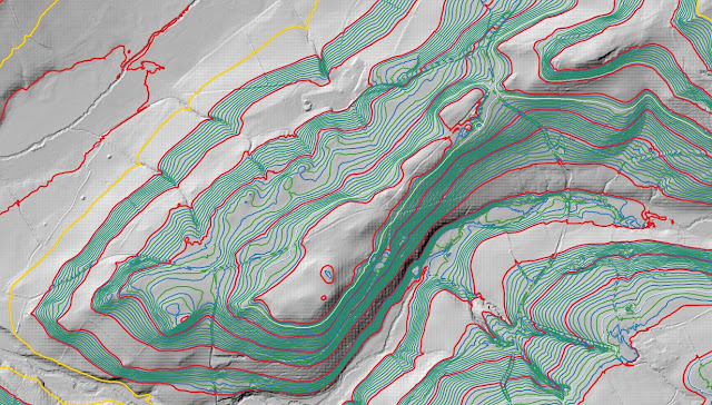%20-%20LIDAR%20hill%202.jpg) |
| LIDAR image of Allt y Geifr (SN 762 284) |
The criteria for the list that this reclassification applies to are:
 |
| The Welsh P15s by Myrddyn Phillips |
The name the hill is listed by is Allt y Geifr, and it is adjoined to the Mynydd Du group of hills, which are situated in the southern part of South Wales (Region B, Sub-Region B5), and it is positioned encircled by minor roads with the A4069 road farther to its north-west and south-west, and has the village of Llangadog towards the west.
When the listing that became known as The Welsh P15s was being compiled, this hill was included in the main P15 list with an estimated c 16m of drop, based on the 174m summit spot height that appeared on the Ordnance Survey Vector Map Local hosted on the Geograph website and which was entitled the Interactive Coverage Map and an estimated c 158m bwlch height, based on interpolation of 5m contouring between 155m – 160m that appeared on the OS Maps website.
%20-%201%2025000.jpg) |
| Extract from the Ordnance Survey 1:25,000 Explorer map |
However, it was not until LIDAR became available that the details for this hill could be accurately re-assessed. The LIDAR (Light Detection & Ranging) technique produced highly accurate height data that is now freely available for much of England and Wales.
Therefore, the reclassification of this hill to Welsh Sub-P15 status is due to LIDAR analysis, resulting in a 171.1m summit height and a 156.9m bwlch height, with these values giving this hill 14.2m of drop, which is insufficient for it to be included in the main list of The Welsh P15s.
The full details for the hill are:
Group: Mynydd Du
Name: Allt y Geifr
OS 1:50,000 map: 146, 160
Summit Height: 171.1m (LIDAR)
Summit Grid Reference: SN 76221 28491 (LIDAR)
Bwlch Height: 156.9m (LIDAR)
Bwlch Grid Reference: SN 76558 28873 (LIDAR)
Drop: 14.2m (LIDAR)
Myrddyn Phillips (June 2024)
Mapping Mountains - Hill Reclassifications - The Welsh P15s
Pt. 181.4m (SN 731 303) – Welsh Sub-P15 reclassified to Welsh P15 (36th reclassification)
There has been a reclassification to the list of The Welsh P15s, with the summit height, bwlch height and their locations, the drop and status of the hill derived from LIDAR analysis conducted by Myrddyn Phillips.
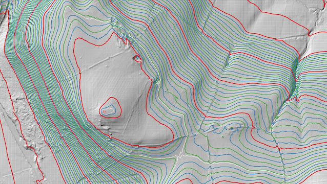%20-%20LIDAR%20hill%202.jpg) |
| LIDAR image of Pt. 181.4m (SN 731 303) |
The criteria for the list that this reclassification applies to are:
 |
| The Welsh P15s by Myrddyn Phillips |
The hill is being listed by the point (Pt. 181.4m) notation as an appropriate name for it either through local enquiry and/or historic research has not been found by the author, and it is adjoined to the Mynydd Du group of hills, which are situated in the southern part of South Wales (Region B, Sub-Region B5), and it is positioned with the A4069 road to its west and a minor road to its south-east, and has the village of Llangadog towards the south-west.
When the listing that became known as The Welsh P15s was being compiled, this hill was included in the P14 sub list with an estimated c 14m of drop, based on the 181m summit spot height that appears on the Ordnance Survey 1:25,000 Explorer map and an estimated c 167m bwlch height, based on interpolation of 5m contouring between 165m – 170m that appeared on the OS Maps website.
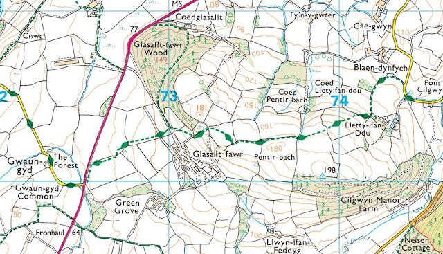%20-%201%2025000.jpg) |
| Extract from the Ordnance Survey 1:25,000 Explorer map |
However, it was not until LIDAR became available that the details for this hill could be accurately re-assessed. The LIDAR (Light Detection & Ranging) technique produced highly accurate height data that is now freely available for much of England and Wales.
Therefore, the reclassification of this hill from Welsh Sub-P15 status is due to LIDAR analysis, resulting in a 181.4m summit height and a 166.2m bwlch height, with these values giving this hill 15.2m of drop, which is sufficient for it to be included in the main list of The Welsh P15s.
The full details for the hill are:
Group: Mynydd Du
Name: Pt. 181.4m
OS 1:50,000 map: 146, 160
Summit Height: 181.4m (LIDAR)
Summit Grid Reference: SN 73163 30392 (LIDAR)
Bwlch Height: 166.2m (LIDAR)
Bwlch Grid Reference: SN 73315 30299 (LIDAR)
Drop: 15.2m (LIDAR)
Myrddyn Phillips (June 2024)


%20-%20LIDAR%20hill%202.jpg)

%20-%201%2025000.jpg)
%20-%20LIDAR%20hill%202.jpg)

%20-%201%2025000.jpg)
No comments:
Post a Comment