
Sixteen Acres (SO 120 987) – 200m Sub-Twmpau addition
There has been confirmation of an addition to the
list of 200m Twmpau, with the summit height, bwlch height
and their locations, the drop and status of the hill confirmed by LIDAR
analysis and a subsequent Trimble GeoXH 6000 survey conducted by Myrddyn
Phillips.
 |
| Sixteen Acres (SO 120 987) |
The criteria for the list that this addition
applies to are:
200m Twmpau
– Welsh hills at or above
200m and below 300m in height that have 30m minimum drop, with an accompanying sub list entitled the 200m
Sub-Twmpau with the criteria for this sub category being all Welsh hills at or
above 200m and below 300m in height with 20m or more and below 30m of drop,
with the word Twmpau being an acronym standing for thirty welsh metre prominences and upward.
 |
| The 200m Twmpau by Myrddyn Phillips |
The name the hill is now
listed by is Sixteen Acres and this was derived from local enquiry, and it is adjoined
to the Carnedd Wen group of hills which are situated
in the south-eastern part of North Wales (Region A, Sub-Region A4), and it is
positioned with the B4390 road to its north, the B4389 road to its west and the
A483 road further to its south-east, and has the village of Tregynon towards
the west.
When the original 200m height band of Welsh P30 hills were published on Geoff Crowder’s v-g.me website this hill was not
included in the accompanying Hills to be
surveyed sub list, as it was considered not to meet the criteria then used
for this sub category.
After the sub list was standardised, and
interpolated heights and drop values also included the details for this hill
were re-assessed and it was listed with an estimated c 20m of drop, based on an
estimated c 216m summit height and the 196m bwlch spot height that appeared on
the Ordnance Survey Vector Map Local hosted on the Geograph website and which
was named the Interactive Coverage Map.
 |
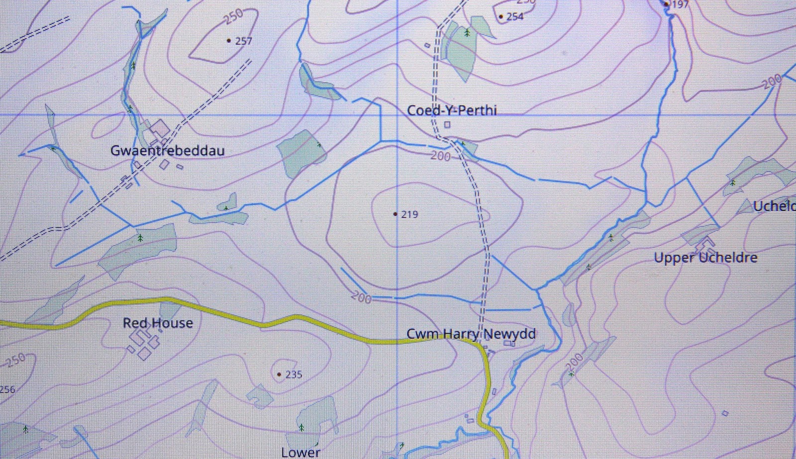
| Extract from the Ordnance Survey 1:25,000 Explorer map |
Since the original publication of the P30 lists of
Geoff Crowder’s v-g.me website there have been a number of Ordnance Survey maps
made available online, some of these are historic such as the series of
Six-Inch maps on the National Library of Scotland website, whilst others are
current and digitally updated such as the mapping on the WalkLakes website and
the Magic Maps website.
One of the mapping resources now available online
is the WalkLakes website which hosts an interactive map originated from the
Ordnance Survey Open Data programme.
This map has many spot heights not on other publicly available Ordnance
Survey maps and for this hill a 219m spot height is given on the area of its
summit.
 |
| Extract from the WalkLakes website |
Another resource available online is the
interactive mapping originated from Ordnance Survey data hosted on the Magic
Maps website. This mapping also shows a 219m
spot height on the summit area of this hill.
 |
| Extract from the Magic Maps website |
However, it was not until LIDAR became available
that the details for this hill could be accurately re-assessed. The LIDAR (Light Detection & Ranging)
technique produced highly accurate height data that is now freely available for
much of England and Wales.
 |
| LIDAR image of Sixteen Acres |
The result produced by LIDAR analysis gives this
hill 20.1m of drop, and as the summit has now been surveyed with the Trimble
GeoXH 6000 it is this result that is being prioritised for listing purposes.
 |
| The Trimble GeoXH 6000 gathering data at the summit of Sixteen Acres |
Therefore, the confirmation of the addition of
this hill to 200m Sub-Twmpau status is due to LIDAR analysis and a Trimble
GeoXH 6000 survey, resulting in a 219.2m summit height and a 199.1m bwlch
height, with these values giving this hill 20.1m of drop, which is sufficient
for it to be classified as a 200m Sub-Twmpau.
The full details for the
hill are:
Group: Carnedd Wen
Name: Sixteen Acres
OS 1:50,000 map: 136
Summit Height: 219.2m (converted to OSGM15, Trimble GeoXH
6000)
Summit Grid
Reference: SO 12005 98756 (Trimble GeoXH
6000)
Bwlch Height: 199.1m (LIDAR)
Bwlch Grid
Reference: SO 11953 98547 (LIDAR)
Drop: 20.1m (Trimble GeoXH 6000 summit and LIDAR
bwlch)
Myrddyn Phillips
(December 2020)
No comments:
Post a Comment