Showing posts with label Surveys: 34 Garn Fawr. Show all posts

Sunday, 24 August 2025

Mapping Mountains – Trimble Surveys – Garn Fawr


17.06.25  Carn Llidi (SM 737 280) 

Carn Llidi (SM 737 280)

Carn Llidi is rock strewn in its higher reaches and protected from any off-path ascent by copious amounts of tough undergrowth.  The hill is positioned north-west of Tyddewi (St David’s) which purports to be the smallest city in the British Isles.  It looks out over a jagged coastline which the Pembrokeshire Coast Path follows.  Although the hills hereabouts are good, it is the coastal path that is the highlight. 

Pentre Ifan

We were based at Caerfai for a few days, which is just to the south and easy walking distance from Tyddewi.  On our way to Caerfai we visited Pentre Ifan, which is one of Wales’ most impressive ancient burial sites with its upper monolith delicately balanced. 

Inside the chapel at St Non's

The coastal path was next to where we stayed; we walked to Solfach (Solva) and bussed it back to the city and on another day headed to the delights of St Non’s; a Catholic retreat beside the coast path. 

The cathedral at Tyddewi

Whilst at Tyddewi the first Welsh Bible was transferred to the cathedral.  It was translated by Bishop William Morgan and published in 1588.  It had never been on public display and along with the first Bible published in Irish was now at the cathedral.  Whilst visiting to see this Bible I stood and listened to four elderly ladies talking amongst themselves in Welsh, whilst pointing at the book housed in its display cabinet.  I found this scene rather emotional as this book played a crucial role in preserving the Welsh language and over 430 years later this small group of neatly dressed women were a testament to the importance of this book and the strength of the language. 

The first Welsh Bible

As well as hills, coastal walks and the cathedral, the land surrounding Twddewi also looks west to a series of islands dominated by Ynys Dewi (Ramsey), which I had visited and surveyed its three P30 hills in May 2016.  However, there are many more islands scattered beyond Ynys Dewi with the main grouping being Emsger, Carreg Rhoson and North Bishop.  And when at Caerfai we took two boat trips; the first around Ynys Dewi and the second a magical evening trip to North Bishop. 

On the coastal path

However stunningly beautiful the coastal path and islands are, and however interesting and historically significant the cathedral is, we also needed a hill to visit.  The one that looked the most impressive was Carn Llidi.  I contemplated bringing the Trimble to survey its summit, but the prospect of carrying the equipment for six days with only one hill to visit was not appealing and therefore the Trimble remained at home and LIDAR would have to suffice for the numerical details of this hill. 

The highest of the chain of islands known as North Bishop

We parked on a grass verge on the B4583 road at it descends to its end at Whitesands beach.  This gave opportunity for a circular walk with only the uphill section back on the narrow paved road at the end of the walk as a repeat. 

Beside the narrow road leading down to Whitesands

Setting off the weather was again lovely; with crisp blue sky heralding what we hoped would be another glorious day.  However, weather hereabouts was proving fickle.  Each evening I watched from the elevation of Caerfai as thin cloud banks quickly rolled landward and then quickly dissipated as the sun cast out again, only for another cloud bank to follow.

Our route took us down to the beach, where we were confronted by a multitude of school children, all donned out in wet suits with their paddle boards aimed at the sea.  It was good to walk on the beach, somewhere we would revisit for an afternoon during a particularly warm spell of weather later in the week.  Our walk this time on its sands was only short as we headed north and soon joined the coastal path. 

Suzanne on the coastal path leading north from Whitesands

This section was like others we had visited with dramatic plummeting views downward to rocky coves, sandy beaches and towering sea stacks, and all experienced with the sea a constant blue and today the sky casting radiant.  It was indeed a good day to be out, but that weather hereabouts is a fickle beast. 

The view back toward Whitesands

We were looking for a path on our right leaving the main coastal path and which, hopefully, would take us toward our hill.  Thankfully we found it as the prospect of walking through the tough undergrowth away from any path is not recommended.

The path swung up gaining ground and always heading toward the western end of the Carn Llidi summit ridge.  As with many similar hills leaving the path can course calamitous results of floundering in copious amounts of evil undergrowth.  Therefore, I thought it prudent to ask one or two fellow walkers who were heading down in the opposite direction, whether and where the path continued.  We were met with conflicting advice, some encouraged going back down to another path and others seemed to discourage anything to do with venturing high on the hill.  I found this advice rather unusual, thanked them and off we went forever upward. 

Murky conditions starting to set in over Ynys Dewi

The path eventually swung up on to a concreted section leading to the summit of Carn Llidi Bychan; an outlier of the main peak and the farthest extension of the rocky western end of the summit ridge.  As height was gained we looked out toward Ynys Dewi, which was now being overtaken by one of those fickle weather conditions with grey murk approaching.

Ancient burial chamber beside the path on the way to Carn Llidi

The initial continuation toward the main peak was easy enough, with a variety of narrow paths leading toward the upthrust of the summit cone.  As we reached where path butted against rock, Suzanne decided that was far enough for her and found a sheltered spot away from the increasing strength of the wind, to wait until I visited the summit and hopefully descended safely back to where she was now happily sitting and admiring the view northward. 

Approaching the summit cone of Carn Llidi

When approaching Carn Llidi from the west its highest point requires hands on rock to reach its summit.  I used to hunt out any scramble and have many fond memories of weekends spent in Nant Peris, evenings in the Vaynol Arms, breakfasts in Pete’s Eats and late mornings and afternoons venturing on to Eryri peaks via scrambling on rocky ridges.  This at that point of my life was the norm.  I found it highly enjoyable and considered myself competent enough to know when to back off from something that looked beyond my limit.  However, age and scrambling not being the norm can quickly lead to lack of confidence on rock, and this was only confounded when in October 2023 I slipped and fell from a rocky ridge close to Moel Hebog.  Falling on the opposite side of the ridge would probably have resulted in death.  I was fortunate to walk away with just a large bruise on my upper thigh and a few scratches.  This experience dampened any confidence I had left when confronted with hands on rock and those scrambles that in my younger days were the norm.  Today was the first time I had encountered rock since the day I had fallen.  This all sounds rather melodramatic, but it is as it is and it feels good to write about such things and be as honest as I can.

Before venturing up the rock I took my rucksack off and left it at the base of the summit cone and safely zipped my camera in its case.  The way up was obvious as the rock was discoloured through many peoples visits over the years, it involved two sections of scrambling before reaching the high point, the first up a diagonal wide groove and the second a metre or two traverse to the left and then up a few steps to where the summit opened up.  By the time I reached the top it was definitely windy, not so much to be dangerous but enough that I was thankful I had decided not to bring the Trimble.

The view north-eastward up the coast from the summit of Carn Llidi

Reversing my upward route was relatively easy, as with most things of a similar nature, taking ones time is essential.  Soon I was back at my rucksack and shortly afterward sitting beside Suzanne tucking in to some yummy morsel of food.  As we gathered our stuff to head down we felt the first drop of rain that was being pushed landward beyond the grey sky murk that we had seen over Ynys Dewi on the latter part of our ascent.

Our route down was easy, reversing the summit ridge to Carn Llidi Bychan and the narrow concrete path leading down to the main path, here we continued down toward the road, instead of swinging rightward and rejoining the coastal path.  This soon brought us out on to the road and that nasty little bit of uphill at the end of the walk, never the best at the end of any walk. 

Relaxing in the car with our picnic with the cloud base now enveloping Carn Llidi

During our descent the weather continued to close in, with those succulent blue skies of earlier now replaced by greying murk with intermittent spells of light coastal drizzle being brought in on the wind.  The rain was never heavy enough for me to put waterproofs on and we arrived back at the car still dry from our endeavours.  All that remained was a quick change whilst the kettle was boiling and to have a feast of a picnic sitting in comfort looking out of the car window as the whole upper ridge of Carn Llidi disappeared under grey murk. 


Survey Result: 


Carn Llidi 

Summit Height:  182.1m (LIDAR)  

Summit Grid Reference:  SM 73797 28001 (LIDAR)

Bwlch Height:  57.8m (LIDAR)

Bwlch Grid Reference:  SM 76096 28625 & SM 76132 28642 (LIDAR) 

Drop:  124.3m (LIDAR)

Dominance:  68.27% (LIDAR)


For further details please consult the Trimble Survey Spreadsheet 

Wednesday, 1 June 2016

Mapping Mountains – Trimble Surveys – Garn Fawr


14.05.16  The Smalls (SM 466 088), Emsger (SM 651 226) and Daufraich (SM 661 236)

Emsger, also known as South Bishop (SM 651 226)

The coast around Pembrokeshire has a reputation for beautiful scenery comprising secluded coves, cliffs, sea stacks and islands.  The islands are many, with Ynys Dewi (Ramsey), Skomer and Skokholm being three of the largest in area.  However, dotted around these three islands are a myriad of smaller ones, many are rocky, some have lighthouses situated on them and all are of interest. 

Over the last couple of years Adrian Rayner has organised a number of ‘island adventures,’ usually these are to islands that are not on the tourist trail where daily boats are scheduled to visit and drop people off for a set number of hours before picking them up and whisking them back to the mainland.  The islands Adrian concentrates on are those that are seldom visited and which require a skilled crew to get to, and drop off, and pick up any budding ascensionist.  These island adventures require diplomatic and logistical skills to organise and thanks should be expressed to Adrian for arranging them, as all I have been a part of have been great fun, packed with interest and variety.  Today’s little adventure comprised a visit to The Smalls, Emsger (South Bishop) and Daufraich, with the first two of these islands having lighthouses situated on them.

We met at St Justinian’s which is situated to the west of St David’s and is the departure point for the RNLI Lifeboat, as well as the departure point for Ynys Dewi (Ramsey).  During the previous night a northerly weather front had descended south and left a slight northern breeze which meant that landing on each island was under debate by the crew of our RIB.  The original departure was arranged for 8.00am, and it was nearing 9.30am when the proverbial thumb was lifted in to the air signifying that the adventure was on.

Our RIB for the day

Ayako heading down to board the RIB

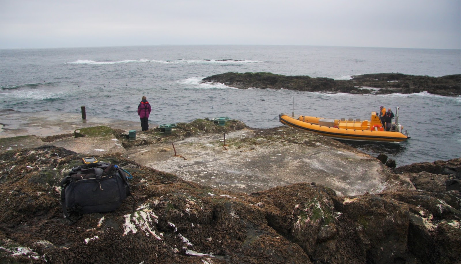
As we skimmed across the water toward the southern part of Ynys Dewi the sky was grey and the sea relatively becalmed.  Our first landing destination was The Smalls which as their name implies are a small group of islets, wave battered and remote, and an approximate 12 miles from the western coast of Pembrokeshire.  This small group of islets are the furthest west of any land in Wales, few people visit and even fewer people land.  On our way we approached the landing steps on Emsger and the skipper judged that landing was feasible after visiting The Smalls as the incoming tide would enable us to land higher on the carved out steps that give access to the upper part of the island.

The landing steps on the northern side of Emsger

Leaving Emsger for later that morning we skimmed off west in to a literal sea of seemingly nothingness, the only rock visible was Gwales (Grassholm) and its adjoined West Tump to our south, these are the remotest P15 summits that Wales has to offer and are perched seven miles west of Skomer, they looked weather beaten and almost forgotten except for their colony of Gannets.  As the RIB made progress a small stick stuck out of the sea, just visible it shimmered its presence and as the RIB continued west the stick grew forever larger and slowly took on the shape of a lighthouse, still and grey it stood forlorn, a last vestige of man’s presence before Ireland is reached.


Gwales, also known as Grassholm (SM 598 093)


The Smalls (SM 466 088) - the furthest westerly point of Wales

The Smalls lighthouse has a fascinating history as an incident here in 1800 when one man died and the other lived in sight of his corpse for the following three months before rescue, initiated future three keeper manning.

As the RIB pulled up and lodged its front end against the steps leading on to the slime of copious amounts of seal poo, we clambered off one after another for our all too brief stay on this small but unique part of Wales. 

Approaching The Smalls.  Seated are (L-R) Rob, Sarah, Bob and Jon

The highest natural piece of rock still visible was agreed upon by a number of people and soon the Trimble was positioned on it gathering its customary five minutes of data.  During this time most people roamed the islet finding evidence of the old wooden piles still embedded in the rock that had formed a part of the older lighthouse.

Sheila looking out to sea

Gathering data at the summit of The Smalls, with (L-R) Jon, Bob, Sarah and Rob in the background

Standing on The Smalls felt rather empty, somewhat of a void, our stay was only brief and because of this we all pottered round investigating what the islet had and doing so as quickly as possible, when this happens time is taken up as is concentration, but even compensating for this the islet is still a forgotten place, an end of something rather than a beginning, a flatbed of wave battered emptiness that must be hell on earth during storms, the thought of manning the old lighthouse that supposedly shuddered during storms fills me with dread.

Wave battered and forlorn, the last vestige of land before Ireland

Sheila joining Adrian on the RIB with Sarah and Bob waiting their turn.  These steps were covered in seal poo and extremely slippy

Once back on the RIB we headed toward Emsger, which has at least two rows of carved steps signifying a landing place, we approached the ones on the island’s north.  On the way I spotted the first Puffins that to my knowledge I’ve ever seen, I was struck with how cute and small they are, almost like a sea budgie with little wings flapping ten to the dozen and with tiny little bodies.

(L-R) Daufraich, Emsger (South Bishop), Carn Llidi (mainland Pembrokeshire) and Carn Ysgubor on Ynys Dewi (Ramsey)

As we approached Emsger (South Bishop) the cloud had broken revealing patches of blue sky which according to the sea mariners aboard the RIB would herald choppier sea conditions.  Again the RIB was manoeuvred in to place with its front end lodged relatively firmly against the rock next to the landing steps and one by one we clambered on to the rock.  This island forms a part of the chain known as the Bishops and Clerks which stretch northward and take in Daufraich, Carreg Rhoson and North Bishop, with the latter two aligned south-west to north-east as rocky lumps of ribbed islets.

The south-eastern side of Emsger


Daufraich (SM 661 236)


Carreg Rhoson (SM 667 254)


(L-R) North Bishop, Carreg Rhoson and Daufraich


Emsger (SM 651 226)

The carved rock steps led steeply up toward the island’s lighthouse which was constructed in 1839, with it being automated and demanned in 1983.  The whole upper part of the island is now a part of the lighthouse and its surrounding ground, any vestige of natural earth or rock was on the periphery of this, with the natural high point of the island long since gone with it either buried under the construction or levelled due to the impending construction of the lighthouse.  Consensus of opinion gave the remaining high point as a scrub bit of earth adjacent to a corner at the base of one of the walls, this at least was convenient for Trimble placement and within a few minutes it was gathering data perched on the wall 0.99m above the patch of earth.

Bob getting on to dryish land on Emsger


Bob and Sarah heading up the steps


Rob and Adrian on the final steps to the lighthouse


Gathering data 0.99m above the highest remaining natural ground that was found

After the Trimble was closed down and packed away I walked down to the helipad which was constructed in 1971.  This gave views back up toward the lighthouse and across the carved westerly steps toward the remainder of the Bishops and Clerks.  By now our stay on Emsger was nearing its end and as I clambered back up the steps and round the lighthouse to the steps on the island’s northerly section people were making their way down to the RIB which had been circling the island during our stay.  Emsger is a great lump of rock which if not for the steps up to its lighthouse would prove a difficult place to get to the top of; it stands squat in the sea as an up thrust of rock with its beacon now signalling its position.

Adrian on the helipad with our RIB circling the island


Looking toward the lighthouse from the helipad


Beyond the westerly steps with North Bishop, Carreg Rhoson and Daufraich in the background


The RIB approaching to pick us up from Emsger

Once we were all safely in the RIB we headed toward Daufraich and approached it from its north.  The main island of Daufraich consists of two parts, with the most easterly given a 20m spot height on Ordnance Survey maps, this looked relatively easy to get to the top of once landed, however the higher 21m map heighted part of the island is its westerly section and this looked decidedly harder to get to the top of, although it did look doable.  As the RIB approached we still didn’t know if the skipper would take us in to attempt a landing, and as we neared the rock it suddenly came apparent that the go ahead had been given and Jon, Rob, Adrian and Bob all made a move toward the front of the RIB, with Ayako, Sheila and Sarah all wisely staying put, not wanting to be put off by a bit of wave battered steep and scrambly rock which for one slip would mean a decidedly wet and somewhat dangerous immersion in the Irish sea, I followed.

Approaching Daufraich


Our route went up somewhere just left of centre

Thankfully the rock proved relatively dry and was not slippy, this gave us all good purchase and although the going was steep there were adequate hand and foot holds to be found.  My confidence on rock is not as it once was, partly because I rarely have necessity to scramble on it these days, and therefore when confronted with 20m of scrambly rock perched above bottomless depths my mind and body goes AAARRRGGGHHHHHHH.  However, all was fine, fine, fine and I followed the others up to the summit.

Somewhere below was the route we'd just come up

The westerly part of Daufraich has two summits, both given the same 21m spot height on Ordnance Survey maps and ideally both needed surveying but time dictated that only one could, and all present agreed that the higher summit was the one that we were standing on, and as the others went over to visit the other 21m map heighted top I positioned the Trimble on what looked to be the true summit and it beeped away perched on its rock as gulls circled overhead and the RIB slowly manoeuvred back toward our landing spot. 

Gathering data at the summit of Daufraich


Carreg Rhoson (SM 667 254)


The Trimble set-up position at the summit of Daufraich

As the Trimble gathered its data I walked over to the other summit and joined Jon, Rob, Adrian and Bob as they assessed which was higher, it was a close call, but the one where the Trimble was positioned received our vote for being the higher. 


Jon checking his hand-held GPS near the summit of Daufraich

Heading toward the second 21m map heighted summit that consensus of opinion gave as slightly lower


Jon at the summit of Daufraich

It was now time to go and I walked back to the Trimble to close it off, take a few photos of its set-up position and set off down the rock to join the others on our downward route.  Rob and Bob partly guided me down and I’m thankful that they did, and after a few minutes of nerve jangling perched over the watery depths we were safely seated in the RIB and the skipper span it round and headed toward the southerly coast of Ynys Dewi (Ramsey).

Jon, Adrian and Bob at the start of the scramble down


Safely back on the RIB and leaving Daufraich

The southerly coastline of this island proved wonderful to see with steep and rock chopped islands butting out of the sea, set against the crumbled cliff line of Ynys Dewi.  The RIB was taken between many of these smaller islands and underneath their sheer cliffs, many plunging directly down from small grassed summits above.  It proved a wondrous place to see as we slowly meandered past the sculptured islands and through a cave where sunlight glimmered across the rock and sea.

The eastern cliffs of Carn Llundain


Rounding the southern part of Ynys Dewi (Ramsey)


Heading through the cave


Being watched

All that remained was a speedy whizz across the sea past The Bitches rocks toward our departure point at St Justinian’s.  It had been another fantastic experience visiting places that few people ever get the opportunity to see let alone stand on, and thanks to Adrian for organising the trip and to Venture Jet for their professionalism and taking us to some of Wales’ more remote islands.


Survey Result:


The Smalls

The summit data for The Smalls did not process, the first data set that has not done so with the Trimble, with the following remark appearing whilst processing:  A position has been detected that is not compatible with the current coordinates.  Perhaps an Irish base station was picked up during data logging or perhaps The Smalls are just so far out in the Irish Sea that coordinates do not exist for processing data!


Summit Height:  33.8m (converted to OSGM15) (significant height revision)

Summit Grid Reference:  SM 65116 22619

Bwlch Height:  N/A (island)

Bwlch Grid Reference:  N/A (island)

Drop:  33.8m

Dominance:  100.00%


Daufraich

Summit Height:  21.7m (converted to OSGM15)
 
Summit Grid Reference:  SM 66199 23673 (summit relocation)

Bwlch Height:  N/A (island)

Bwlch Grid Reference:  N/A (island)

 
Dominance:  100.00%