Tuesday 30 November 2021

Mapping Mountains – Summit Relocations – Y Trechol – The Dominant Hills of Wales


Cefn Carnau (ST 165 847) 

There has been a Summit Relocation to a hill that is listed in the Y Trechol – The Dominant Hills of Wales, with the summit height, bwlch height and their locations, the drop, dominance and status of the hill initiated by Joe Nuttall who produced a summit analysis programme using LIDAR, and then by LIDAR analysis initially conducted by Jim Bloomer and subsequently by Myrddyn Phillips. 

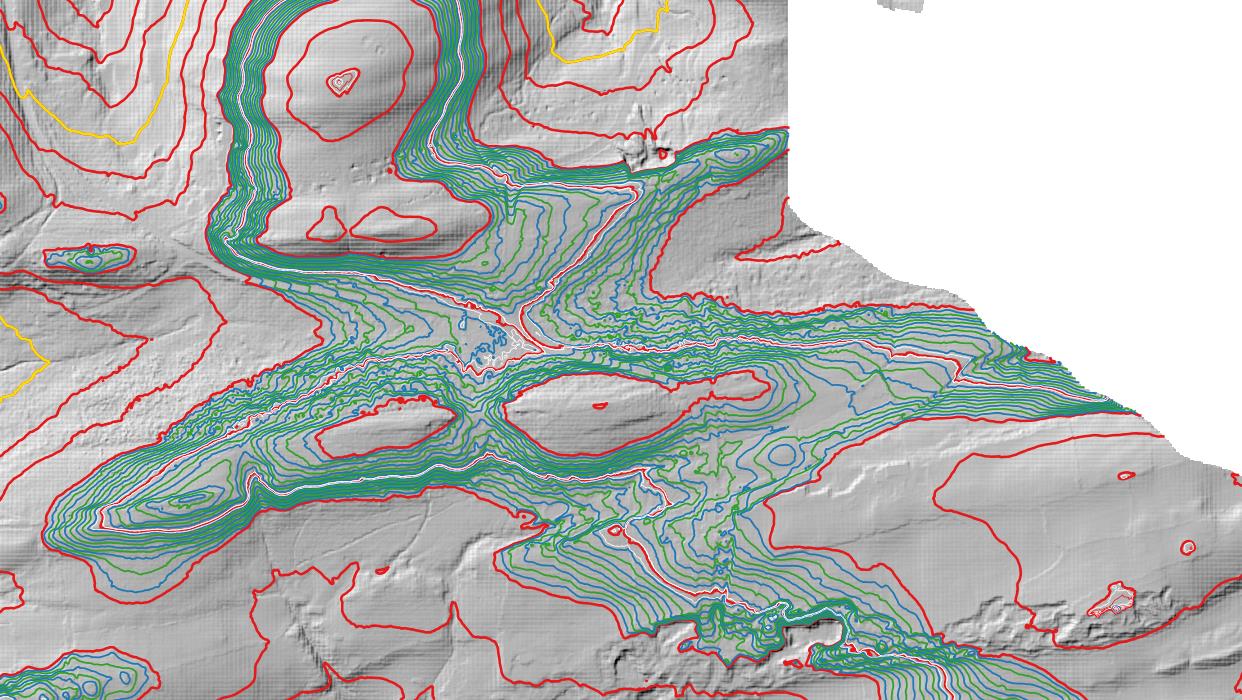
LIDAR image of Cefn Carnau (ST 165 847)

The criteria for the list that this summit relocation applies to are: 

Y Trechol – The Dominant Hills of Wales – Welsh P30 hills whose prominence equal or exceed half that of their absolute height.  With the criteria for Lesser Dominant status being those additional Welsh P30 hills whose prominence is between one third and half that of their absolute height.  The list is authored by Myrddyn Phillips with the Introduction to the start of the Mapping Mountains publication of this list appearing on the 3rd December 2015, and the list is now available in its entirety on Mapping Mountains in Google Doc format. 

Y Trechol - The Dominant Hills of Wales by Myrddyn Phillips

The name the hill is listed by is Cefn Carnau and it is adjoined to the Cymoedd Gwent group of hills, which are situated in the eastern part of South Wales (Region C, Sub-Region C2), and it is positioned with a minor road to its north, the A469 road to its west, the M4 motorway to its south and a minor road to its east, and has the town of Caerffili (Caerphilly) towards the north-west. 

When the original 200m height band of Welsh P30 hills was published on Geoff Crowder’s v-g.me website, this hill was listed with a 270m summit height based on the spot height that appears on the Ordnance Survey 1:25,000 Explorer map and which is positioned at ST 16625 84801. 

When the 200m P30 list was published on Geoff Crowder’s v-g.me website the adjacent hill; Comin Caerffili was listed with a 271m summit height based on the spot height that appears adjoined to a triangulation pillar on the Ordnance Survey 1:50,000 Landranger and 1:25,000 Explorer map.  As Comin Caerffili was given a higher map height than Cefn Carnau it was the former that was listed as a Lesser Dominant hill with 109m of drop and 40.22% dominance, based on the 162m bwlch spot height that appeared on the Ordnance Survey Vector Map Local hosted on the Geograph website and which was entitled the Interactive Coverage Map. 

Extract from the Ordnance Survey 1:25,000 Explorer map

However, it was not until LIDAR became available that the details for these two hills could be accurately re-assessed.  The LIDAR (Light Detection & Ranging) technique produced highly accurate height data that is now freely available for much of England and Wales. 

The summit height produced by LIDAR analysis for these two hills is given below:


271.859m at ST 16511 84707 for Cefn Carnau 

270.760m at ST 15301 85529 for Comin Caerffili


With the caveat that the 271.859m summit height for Cefn Carnau is obtained from 2m DTM LIDAR, with 1m DTM LIDAR giving a summit height of 271.791m.  The latter is likely to be an anomaly as 1m LIDAR has a greater accuracy than 2m LIDAR and therefore usually produces a greater height.  Contouring on the 1m DTM LIDAR also suggests an anomaly. 

The heights given above come within the parameters of the Summit Relocations used within this page heading, these parameters are: 

The term Summit Relocations applies when the high point of the hill is found to be positioned; in a different field, within a different map contour, to a different feature such as in a conifer plantation, to a different point where a number of potential summit positions are within close proximity, a relocation of approximately 100 metres or more in distance from either the position of a map spot height or from where the summit of the hill was previously thought to exist, or when natural ground or the natural and intact summit is confirmed compared to a higher point such as a raised field boundary that is judged to be a relatively recent man-made construct. 

Therefore, the listed summit height of this hill is 271.9m and its new position is ST 16511 84707, this is approximately 100 metres from the position of the 270m spot height that appears on the contemporary Ordnance Survey 1:25,000 Explorer map, and is approximately 1450 metres south-eastward from where the previously listed summit is positioned. 


The full details for the hill are:

Group:  Cymoedd Gwent

Name:  Cefn Carnau 

OS 1:50,000 map:  171

Summit Height:  271.9m (LIDAR)                                                           

Summit Grid Reference (New Position):  ST 16511 84707 (LIDAR) 

Bwlch Height:  163.8m (LIDAR) 

Bwlch Grid Reference:  ST 14268 85037 (LIDAR) 

Drop:  108.0m (LIDAR) 

Dominance:  39.73% (LIDAR)


Myrddyn Phillips (November 2021)


Monday 29 November 2021

Mapping Mountains – Trimble Surveys – Moel y Gamelin


20.09.21  Pt. 212.2m (SJ 304 530) 

The summit field of Pt. 212.2m (SJ 304 530)

After visiting Bryn y Gaer (SJ 313 574) and Windy Hill (SJ 307 548) I navigated my way on to the B5101 road and with map in left hand and steering wheel in right, miraculously chose the right roads to turn on to and found my way driving up a narrow seemingly seldom used lane with overgrown hedgerows scraping the sides of my car.  Cresting the upper part of the lane brought me to houses, where I asked permission to pull my car adjacent to the side of someone’s front gardened wall.  With permission granted I headed for the hill. 

When I say headed for the hill, all this entailed was walking back a few metres up the lane to where a slight gap emerged in the hedge on my right, this would give access to the upper field where the summit of the hill was positioned. 

The gap in the hedge proved fun; it had two strands of floppy barbed wire across it and was relatively narrow, with the hedge consisting of thorns.  I straddled the barbed wire and delicately picked my way through the hedge with a tug and a pull and eventually emerged on a closely cropped grassy field, which online logs indicate is used as a paddock.  When driving toward the narrow lane I noticed a number of horses on the lower part of the field, when on its summit they thankfully remained out of sight. 

It was only a short walk from where I had emerged on to the field to the summit.  When approaching it I assessed the lay of land and zeroed in on what looked to be the high point, when there I put my rucksack down to mark the position.  I then assessed this point from a number of directions and decided to take two data sets, each a few metres apart. 

Having set the Trimble up for its first summit data set I walked back toward the hedge a safe distance away from the equipment, so as not to disturb satellite reception, and waited for the allotted data to be gathered and stored. 

Gathering data at the summit of Pt. 212.2m (SJ 304 530)

After closing the equipment down I repositioned it on the second position I judged to be a contender as high point for this hill and again stood back as the Trimble gathered data.  During data collection I looked west and tried to distinguish where my next hill; Middle Field (SJ 282 533) was positioned.  Since my Ordnance Survey 1:25,000 Explorer map was published there has been redevelopment in this area with a number of new houses and accompanying road networks and therefore trying to pinpoint my next hill in relation to these was not ideal as they did not appear on my map! 

The Trimble set-up position at the summit of Pt. 212.2m (SJ 304 530)

Prior to visiting this hill I had looked at LIDAR, the summit is not yet covered but the bwlch is and having produced an accurate height and position for this, it can now be combined with the result produced by the Trimble GeoXH 6000 survey to give an accurate drop for this hill. 

LIDAR bwlch image of Pt. 212.2m (summit at SJ 304 530)

Once the second data set was safely gathered and stored I closed the equipment down and headed back to the narrow gap in the hedge.  Before attempting my exit I took my rucksack off and put it through the small gap, this at least gave me a semblance of dignity as I struggled through and over the boundary hedge and barbed wire.  Once through the hedge and back on the lane it was only a short walk to my car. 


Survey Result: 


Pt. 212.2m (significant name change)

Summit Height:  212.2m (converted to OSGM15, Trimble GeoXH 6000) (the same 212.191m height produced by the two Trimble GeoXH 6000 surveys)

Summit Grid Reference:  SJ 30413 53067 & SJ 30417 53061 (Trimble GeoXH 6000) (summit relocation confirmed)

Bwlch Height:  176.9m (LIDAR)

Bwlch Grid Reference:  SJ 29817 53587 (LIDAR)

Drop:  35.3m (Trimble GeoXH 6000 summit and LIDAR bwlch)

Dominance:  16.65% (Trimble GeoXH 6000 summit and LIDAR bwlch)


For further details please consult the Trimble Survey Spreadsheet


Sunday 28 November 2021

Mapping Mountains – Significant Name Changes – Y Trichant – The 300m Hills of Wales


Pt. 353.6m (SJ 249 539) 

There has been a Significant Name Change to a hill that is listed in the Y Trichant – The 300m Hills of Wales, with the summit height, bwlch height and their locations, the drop and status of the hill derived from detail on contemporary maps produced from Ordnance Survey data and from LIDAR analysis and a subsequent Trimble GeoXH 6000 survey conducted by Myrddyn Phillips. 

Pt. 353.6m (SJ 249 539)

The criteria for the list that this name change applies to are: 

Y Trichant The 300m Hills of Wales.  Welsh hills at or above 300m and below 400m in height that have 30m minimum drop, with an accompanying sub list entitled the Sub-Trichant with the criteria for this sub category being all Welsh hills at or above 300m and below 400m in height with 20m or more and below 30m of drop.  The list is authored by Myrddyn Phillips, with the Introduction to the list and the renaming of it appearing on Mapping Mountains on the 13th May 2017. 

Y Trichant - The 300m Hills of Wales by Myrddyn Phillips

The hill is adjoined to the Moel y Gamelin group of hills, which are situated in the north-eastern part of North Wales (Region A, Sub-Region A2), and it is positioned with minor roads to its north, east and south, the B5430 road to its west and the A525 road farther to its south, and has the village of Bwlchgwyn towards the east south-east. 

The hill appeared in the original Welsh 300m P30 list on Geoff Crowder’s v-g.me website, under the transposed and invented name of Gwern Hill, with an accompanying note stating; Name from hall to the South-West.


Gwern Hill353mSJ251543117256Name from hall to the South-West


During my early hill listing I thought it appropriate to either invent a name for a hill, or use a name that appeared near to the summit of the hill on Ordnance Survey maps of the day.  My preference was to use farm names and put Pen, Bryn or Moel in front of them or as in this instance transpose the name of a hall and add the word Hill to it.  This is not a practice that I now advocate as with time and inclination place-name data can be improved either by asking local people or by examining historic documents, through this form of research an appropriate name for the hill can usually be found. 

Extract from the Ordnance Survey 1:25,000 Explorer map

However, occasionally even when research is conducted an appropriate name for the hill may not be found, and on such occasions the listing protocol is to use the point (Pt. 353.6m) notation, and for this hill this is such an example. 

Therefore, the name this hill is now listed by in the Y Trichant – The 300m Hills of Wales is Pt. 353.6m, and this is being used as the author has not found an appropriate name for the hill either through historic research and / or local enquiry. 


The full details for the hill are: 

Group:  Moel y Gamelin 

Name:  Pt. 353.6m 

Previously Listed Name:  Gwern Hill 

OS 1:50,000 map:  117

Summit Height:  353.6m (converted to OSGM15, Trimble GeoXH 6000) 

Summit Grid Reference:  SJ 24997 53989 (Trimble GeoXH 6000) 

Bwlch Height:  c 322m (interpolation) 

Bwlch Grid Reference:  SJ 24041 53999 (interpolation) 

Drop:  c 32m (Trimble GeoXH 6000 summit and interpolated bwlch) 


Myrddyn Phillips (November 2021)


Saturday 27 November 2021

Mapping Mountains – Trimble Surveys – Moel y Gamelin


20.09.21  Windy Hill (SN 307 548) 

LIDAR image of Windy Hill (SJ 307 548)

The summit of this hill seemed relatively easy to reach, as examining the local roads with the aid of a Google Car showed a convenient parking place just to the north of the summit next to a gravel track and paved drive, with the latter leading to a house.  Above the paved drive was a field and the summit was either in the corner of it or across a boundary wall in a wood that forms a part of a disused quarry. 

I decided against a direct route up the field via the paved drive as it looked as if the land formed a part of the house’s garden.  Instead I opted for the gravel track.  This led past a number of houses with no direct access to the east which would take me up toward the summit.  However, even with direct access the continuing route from this direction did not look welcoming with an overgrown wood and no sign of a path, so I continued until reaching the end of the gravel track at a house named Rock Cottage. 

Once next to the cottage the gravel track swung leftward and upward, I followed it.  I now entered an overgrown small field above and also beside, the cottage.  I hoped this would give access to the field beyond a large unsavoury and overgrown hedge that barred me from where I wanted to go.  It didn’t, so I backtracked and found an alternative path that took me around and up the southerly flank of the hill.  However, although this path was good it was taking me away from the summit so I clambered over a collapsed gate and tried my utmost to avoid a patch of nettles.  Usually collapsed gates are relatively easy to get over, this had other obstacles involved and landing on the other side gave me hope that I would get to the summit in one piece.  I was now in the field leading toward the top of the hill, the view to my north-east opened up looking out across the flatlands leading in to England. 

The path leading toward the collapsed gate

Prior to visiting this hill I had LIDARed its summit and noted the ten figure grid reference to be a few metres from that given on the Hill Bagging website.  I hoped the LIDAR co-ordinates to be correct as it looked as if this was in a field beside the boundary next to the wood and disused quarry, whilst the summit position given on the Hill Bagging website gives the high point a few metres over a fence amongst trees. 

The field leading toward the summit

When I reached the top of the field I activated the Trimble and used it as a hand-help device and zeroed in to the co-ordinates I had noted from the Hill Bagging website, it pointed toward a fence made of cut and fashioned branches.  This was higher than a normal fence and for my no longer young and lithe frame proved another cumbersome obstacle to overcome.  Eventually I made it in to the wood on the opposite side and stood on the mound that Hill Bagging gives as the summit.  This position certainly looked the high point, but the LIDAR position was farther north toward a wall and boundary corner, I headed that way to have a look, but soon came back satisfied that the mound was higher. 

The fence leading in to the wood with the summit just beyond

I examined the ground and found a small embedded rock which I judged to be the high point and therefore I soon had the Trimble set up on top of my rucksack, and with the measurement offset noted between its internal antenna and the ground at its base I set it to ebb down to its 0.1m accuracy level before data should be logged.  This took about 20 minutes to achieve, but I was happy enough in the wood, not doing much, just standing, relaxing and recovering from cumbersome fence crossings.  Once the 0.1m accuracy level was attained I pressed ‘Log’ and stood back and below the equipment so as not to disturb satellite reception. 

Gathering data at the summit of Windy Hill

During data collection nothing else stirred, I ate a boiled egg and waited whilst looking down in to the bottom of the discussed quarry.  Prior to the quarry I suspect the natural summit of this hill was higher than where the Trimble was now placed, with LIDAR contouring suggesting the summit had been quarried away. 

The onward route from the summit and down the field

After five minutes of data were gathered and stored I closed the equipment down and headed to the boundary wall and the path on its opposing side.  This followed the wall down, but I suspected it ended in someone’s back garden or just petered out, so I followed another path adjacent to the fence that formed the boundary with the field where I had been earlier, this thankfully led on to the open field above my car.  I wandered down it and was soon overlooking the house at the end of the paved drive.  Just as I headed toward steps leading down to the paved section a man appeared and I waved and apologised for suddenly appearing in his back garden, he smiled and we chatted for about ten minutes or so.  He told me about the sections of undergrowth he had cut to make the path I had just been on.  He proved very pleasant to meet and when I asked him about the name of the hill, he replied that it is known as Windy Hill. 


Survey Result: 


Windy Hill

Summit Height:  174.0m (converted to OSGM15, Trimble GeoXH 6000)

Summit Grid Reference:  SJ 30743 54849 (Trimble GeoXH 6000)

Bwlch Height:  131m (spot height)

Bwlch Grid Reference:  SJ 30729 53674 (spot height)

Drop:  43m (Trimble GeoXH 6000 summit and spot height bwlch)

Dominance:  24.73% (Trimble GeoXH 6000 summit and spot height bwlch)


For further details please consult the Trimble Survey Spreadsheet

Friday 26 November 2021

Mapping Mountains – Significant Name Changes – Y Trichant – The 300m Hills of Wales and Y Trechol – The Dominant Hills of Wales


Fforest (SN 777 393) 

There has been a Significant Name Change to a hill that is listed in the Y Trichant – The 300m Hills of Wales and Y Trechol – The Dominant Hills of Wales, with the summit height, bwlch height and their locations, the drop, dominance and status of the hill derived from LIDAR analysis conducted by Myrddyn Phillips. 

LIDAR image of Fforest (SN 777 393)

The criteria for the two listings that this name change applies to are: 

Y Trichant The 300m Hills of Wales.  Welsh hills at or above 300m and below 400m in height that have 30m minimum drop, with an accompanying sub list entitled the Sub-Trichant with the criteria for this sub category being all Welsh hills at or above 300m and below 400m in height with 20m or more and below 30m of drop.  The list is authored by Myrddyn Phillips, with the Introduction to the list and the renaming of it appearing on Mapping Mountains on the 13th May 2017. 

Y Trichant - The 300m Hills of Wales by Myrddyn Phillips

Y Trechol – The Dominant Hills of Wales – Welsh P30 hills whose prominence equal or exceed half that of their absolute height.  With the criteria for Lesser Dominant status being those additional Welsh P30 hills whose prominence is between one third and half that of their absolute height.  The list is authored by Myrddyn Phillips with the Introduction to the start of the Mapping Mountains publication of this list appearing on the 3rd December 2015, and which is now available in its entirety on Mapping Mountains in Google Doc format. 

Y Trechol - The Dominant Hills of Wales by Myrddyn Phillips

The hill is adjoined to the Elenydd group of hills, which are situated in the central part of the Mid and West Wales Region (Region B, Sub-Region B2), and it is positioned with minor roads to its west and south-east, and the A483 road farther to its south-east, and has the town of Llanymddyfri (Llandovery) towards the south. 

When the original 300m height band of Welsh P30 hills were published on Geoff Crowder’s v-g.me website, this hill was listed under the directional name of Fforest North-East Top, with an accompanying note stating; Name from hill to the South-West.


Fforest North-East Top341mSN778393146/160187Name from hill to the South-West.


During my early hill listing I thought it appropriate to either invent a name for a hill, or use a name that appeared near to the summit of the hill on Ordnance Survey maps of the day.  My preference was to use farm names and put Pen, Bryn or Moel in front of them, or as in this instance use a directional name based on the name given an adjacent hill to the south-west on the contemporary Ordnance Survey 1:25,000 Explorer map.  This is not a practice that I now advocate as with time and inclination place-name data can be improved either by asking local people or by examining historic documents, through this form of research an appropriate name for the hill can usually be found. 

Extract from the Ordnance Survey 1:25,000 Explorer map

The previously listed name of Fforest North-East Top was based on the position of the name Fforest on the Ordnance Survey 1:25,000 Explorer map.  This position is at contrast to how it appears on the Ordnance Survey 1:50,000 Landranger map, with the former intimating that the name is just applicable to the lower adjacent hill to the south-west, whilst the latter intimates that the name is applicable to both hills. 

Extract from the Ordnance Survey 1:50,000 Landranger map

Since publication of these P30 lists on Geoff Crowder’s v-g.me website there have been a number of Ordnance Survey maps made available online, some of these are historic such as the series of Six-Inch maps on the National Library of Scotland website, whilst others are current and digitally updated such as the old Vector Map Local hosted on the Geograph website and which was named the Interactive Coverage Map and the interactive mapping on the Magic Maps and WalkLakes websites.  One of the historic maps now available is the Ordnance Survey One-Inch ‘Old Series’ map which when coupled with the positioning on this hill’s name on the Ordnance Survey 1:50,000 Landranger map formed the basis for the change in this hill’s listed name. 

Extract from the Ordnance Survey One-Inch 'Old Series' map

The One-Inch ‘Old Series’ map was the first map that the Ordnance Survey produced, and their publication culminated from the whole of Britain being surveyed between 1791 and 1874 and the detail gathered therein produced at a scale of one inch to the mile and published in sheet format between 1805 and 1874.  The One-Inch ‘Old Series’ maps for the whole of Wales are now available online; they are also available in map format as enlarged and re-projected versions to match the scale and dimensions of the Ordnance Survey 1:50,000 Landranger series and are published by Cassini.  This series of maps form another important part in the study of Welsh upland place-names and bridge the timeframe leading up to the production of the Ordnance Survey base map of the Six-Inch series, and importantly for this hill and its listed name, it is this map that shows the extended name of Fforest taking in this hill and its lower adjacent hill to the south-west. 

Therefore, the name this hill is now listed by in the Y Trichant – The 300m Hills of Wales and Y Trechol – The Dominant Hills of Wales is Fforest, and this was derived from the Ordnance Survey 1:50,000 Landranger map and substantiated by the Ordnance Survey One-Inch ‘Old Series’ map. 


The full details for the hill are: 

Group:  Elenydd 

Name:  Fforest 

Previously Listed Name:  Fforest North-East Top 

OS 1:50,000 map:  146, 160

Summit Height:  341.3m (LIDAR)                                                           

Summit Grid Reference:  SN 77781 39333 (LIDAR) 

Bwlch Height:  197.4m (LIDAR) 

Bwlch Grid Reference:  SN 78243 41343 (LIDAR) 

Drop:  143.9m (LIDAR) 

Dominance:  42.17% (LIDAR) 


Myrddyn Phillips (November 2021)