Mapping Mountains - Summit Relocations - Y Trichant
Llanfilo Camp (SO 113 327) - 50th summit relocation
Significant Height Revisions post for Llanfilo Camp
Significant Name Changes post for Llanfilo Camp
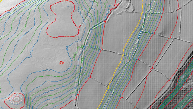
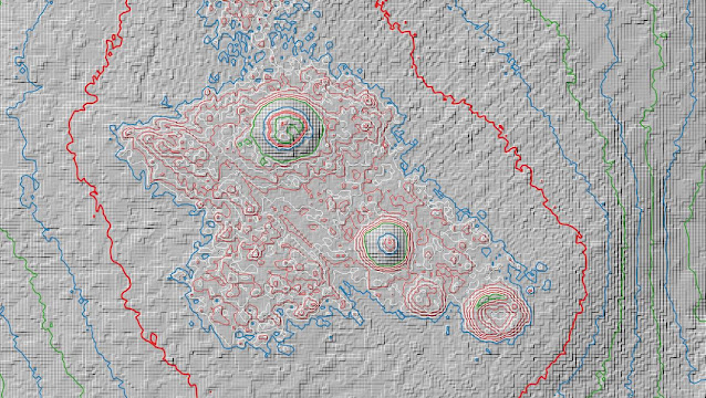
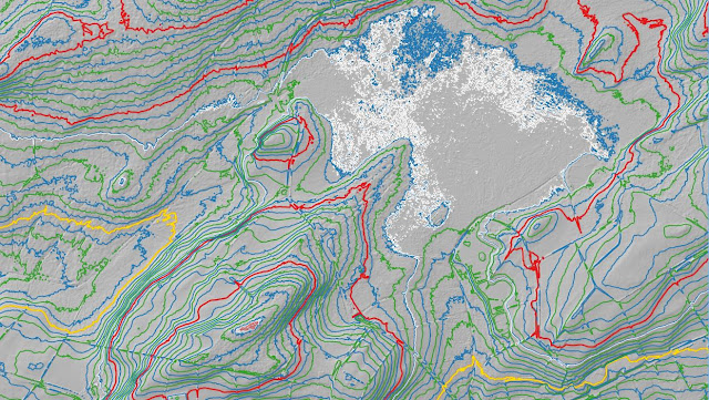
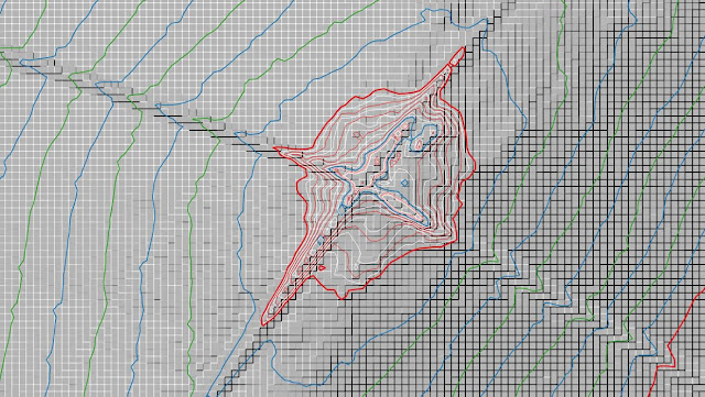
There has been a Summit Relocation to a hill that is listed in the Y Trichant – The 300m Hills of Wales, with the summit height, bwlch height and their locations, the drop and status of the hill derived from LIDAR analysis conducted by Myrddyn Phillips.
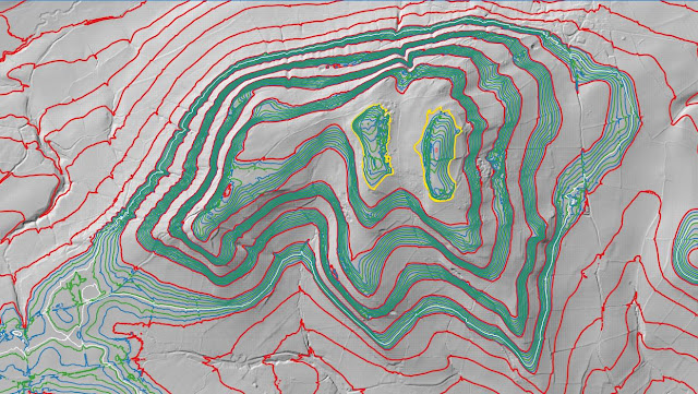%20-%20LIDAR%20hill%202.jpg) |
| LIDAR image of Llanfilo Camp (SO 113 327) |
The criteria for the list that this summit relocation applies to are:
 |
| Y Trichant - The 300m Hills of Wales by Myrddyn Phillips |
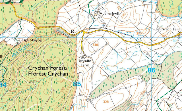
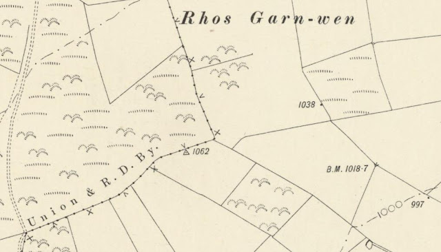
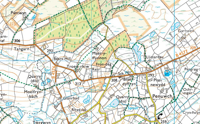
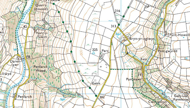
The name the hill is now listed by is Llanfilo Camp and this was derived from information supplied by Coflein, and it is adjoined to the Mynydd Epynt group of hills, which are situated in the central part of South Wales (Region B, Sub-Region B1), and it is positioned encircled by minor roads, with the A38 road farther to its north and the B4560 road farther to its east, and has the town of Talgarth towards the east north-east.
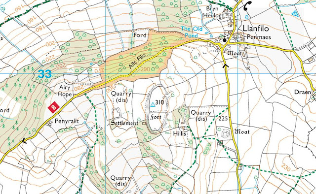%20-%201%2025000.jpg) |
| Extract from the Ordnance Survey 1:25,000 Explorer map |
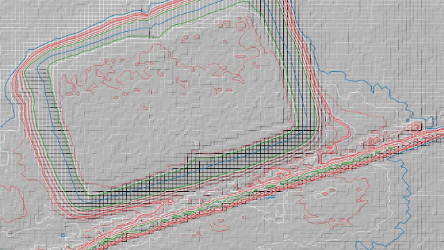
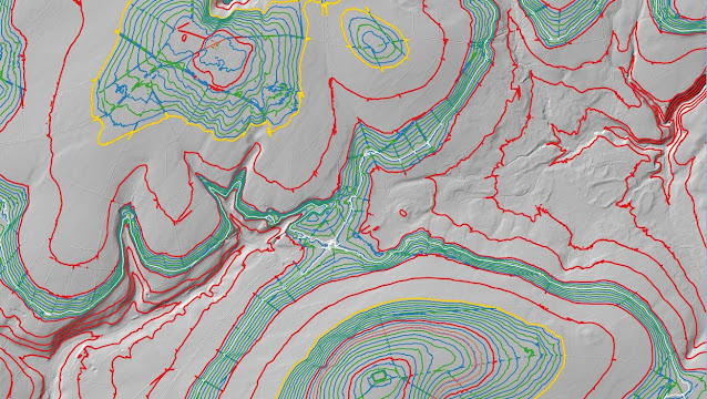
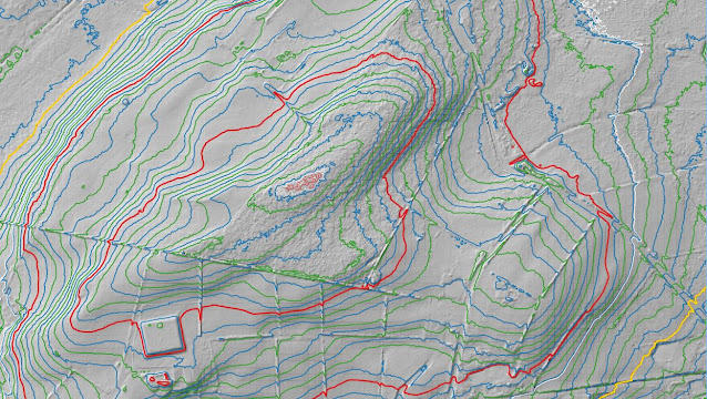
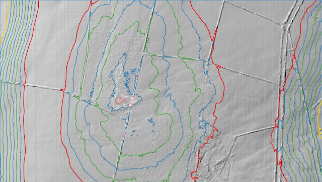
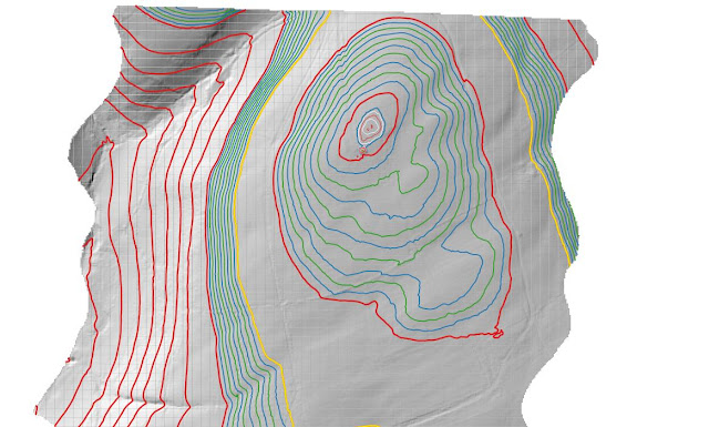
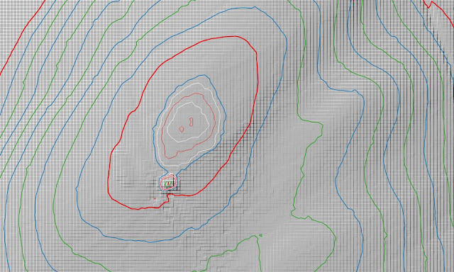
However, it was not until LIDAR became available that the details for this hill could be accurately re-assessed. The LIDAR (Light Detection & Ranging) technique produced highly accurate height data that is now freely available for much of England and Wales.
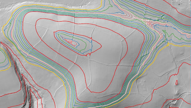
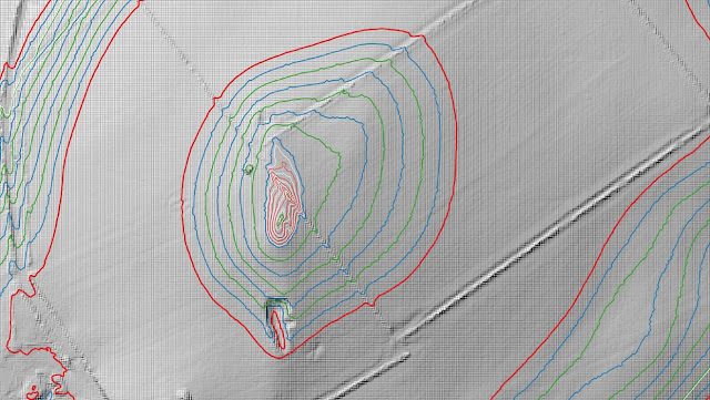
%20-%20LIDAR%20summit%203.jpg) |
| LIDAR summit image of Llanfilo Camp (SO 113 327) |
LIDAR analysis gives the highest ground on this hill as 310.4m positioned at SO 11352 32709, and this in relation to the previously listed summit position which LIDAR analysis gives as 310.0m in height and positioned at SO 11351 32749 comes within the parameters of the Summit Relocations used within this page heading, these parameters are:
The term Summit Relocations applies when the high point of the hill is found to be positioned; in a different field, to a different feature such as in a conifer plantation, within a different map contour, to a different point where a number of potential summit positions are within close proximity, when natural ground or the natural and intact summit of a hill is confirmed compared to a higher point such as a raised field boundary or covered reservoir that is considered a relatively recent man-made construct, or a relocation of approximately 100 metres or more in distance from either the position of a map spot height or from where the summit of the hill was previously thought to exist.
Therefore, the summit height produced by LIDAR analysis is 310.4m and this is positioned at SO 11352 32709, this position is not given a spot height or a 310m contour ring on the contemporary Ordnance Survey 1:50,000 Landranger and 1:25,000 Explorer map, and is approximately 40 metres southward from where the previously listed summit is positioned and importantly to a different feature; being relocated from a triangulation pillar to an ancient earthwork.
The full details for the hill are:
Group: Mynydd Epynt
Name: Llanfilo Camp
OS 1:50,000 map: 161
Summit Height: 310.4m (LIDAR)
Summit Grid Reference (New Position): SO 11352 32709 (LIDAR)
Bwlch Height: 223.6m (LIDAR)
Bwlch Grid Reference: SO 09879 31998 (LIDAR)
Drop: 86.8m (LIDAR)
Myrddyn Phillips (April 2024)
Mapping Mountains - Summit Relocations - Y Trichant
Mynydd y Garth (SN 711 081) - 49th summit relocation
There has been a Summit Relocation to a hill that is listed in the Y Trichant – The 300m Hills of Wales, with the summit height, bwlch height and their locations, the drop and status of the hill derived from LIDAR analysis conducted by Myrddyn Phillips.
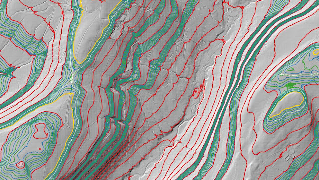%20-%20LIDAR%20hill%202.jpg) |
| LIDAR image of Mynydd y Garth (SN 711 081) |
 |
| Y Trichant - The 300m Hills of Wales by Myrddyn Phillips |
The name the hill is listed by is Mynydd y Garth and it is adjoined to the Mynydd Du group of hills, which are situated in the southern part of South Wales (Region B, Sub-Region B5), and it is positioned with a minor road to its north and east, and the A474 road to its west, and has the town of Pontardawe towards the south.
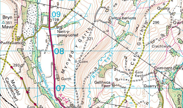%20-%201%2050000.jpg) |
| Extract from the Ordnance Survey 1:50,000 Landranger map |
%20-%201%2025000.jpg) |
| Extract from the Ordnance Survey 1:25,000 Explorer map |
However, it was not until LIDAR became available that the details for this hill could be accurately re-assessed. The LIDAR (Light Detection & Ranging) technique produced highly accurate height data that is now freely available for much of England and Wales.
%20-%20LIDAR%20summit%203.jpg) |
| LIDAR summit image of Mynydd y Garth (SN 711 081) |
LIDAR analysis gives the highest ground on this hill as 321.8m positioned at SN 71149 08116, and this in relation to the previously listed summit position which LIDAR analysis gives as 321.0m in height and positioned at SN 71306 08392 comes within the parameters of the Summit Relocations used within this page heading, these parameters are:
The term Summit Relocations applies when the high point of the hill is found to be positioned; in a different field, to a different feature such as in a conifer plantation, within a different map contour, to a different point where a number of potential summit positions are within close proximity, when natural ground or the natural and intact summit of a hill is confirmed compared to a higher point such as a raised field boundary or covered reservoir that is considered a relatively recent man-made construct, or a relocation of approximately 100 metres or more in distance from either the position of a map spot height or from where the summit of the hill was previously thought to exist.
Therefore, the summit height produced by LIDAR analysis is 321.8m and this is positioned at SN 71149 08116, this position is not given a spot height on the contemporary Ordnance Survey 1:50,000 Landranger and 1:25,000 Explorer map, and is approximately 280 metres south south-westward from where the previously listed summit is positioned.
The full details for the hill are:
Group: Mynydd Du
Name: Mynydd y Garth
OS 1:50,000 map: 160
Summit Height: 321.8m (LIDAR)
Summit Grid Reference (New Position): SN 71149 08116 (LIDAR)
Bwlch Height: 296.1m (LIDAR)
Bwlch Grid Reference: SN 71524 08760 (LIDAR)
Drop: 25.7m (LIDAR)
Myrddyn Phillips (March 2024)
Mapping Mountains - Summit Relocations - Y Trichant
Cwm Helyg (SO 121 460) - 48th summit relocation
Significant Name Changes post for Cwm Helyg
There has been a Summit Relocation to a hill that is listed in the Y Trichant – The 300m Hills of Wales, with the summit height, bwlch height and their locations, the drop and status of the hill derived from detail produced by Joe Nuttall in his surface analysis programme, with subsequent LIDAR analysis conducted by the DoBIH team and independently by Myrddyn Phillips.
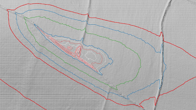
%20-%20LIDAR%20hill%203.jpg) |
| LIDAR image of Cwm Helyg (SO 121 460) |
The criteria for the list that this summit relocation applies to are:
 |
| Y Trichant - The 300m Hills of Wales by Myrddyn Phillips |
The name the hill is now listed by is Cwm Helyg and this was derived from the Tithe map, and it is adjoined to the Gwaun Ceste group of hills, which are situated in the eastern part of South Wales (Region B, Sub-Region B3), and it is positioned with a minor road to its north and south-west, the A470 road farther to its west and the B4594 road to its south-east, and has the small community of Erwyd (Erwood) towards the south-west.
After the sub list was standardised, and interpolated heights and drop values also included the details for this hill were re-evaluated and it was listed with an estimated c 26m of drop, based on the 332m summit spot height positioned at SO 12205 46007 and an estimated c 306m bwlch height, based on interpolation of 10m contouring between 300m – 310m.
%20-%201%2025000.jpg) |
| Extract from the Ordnance Survey 1:25,000 Explorer map |
However, it was not until LIDAR became available that the details for this hill could be accurately re-assessed. The LIDAR (Light Detection & Ranging) technique produced highly accurate height data that is now freely available for much of England and Wales.
LIDAR analysis gives the highest ground on this hill as 333.8m positioned at SO 12132 46026. However, this is a part of an old raised field boundary and protocols dictate that as this is deemed a relatively recent man-made construct such ground is discounted from the height of a hill.
%20-%20LIDAR%20summit%202.jpg) |
| LIDAR summit image of Cwm Helyg (SO 121 460) |
The height produced by LIDAR analysis to the natural summit of this hill is 333.5m positioned at SO 12120 46030, and this position in relation to the old raised field boundary comes within the parameters of the Summit Relocations used within this page heading, these parameters are:
The term Summit Relocations applies when the high point of the hill is found to be positioned; in a different field, to a different feature such as in a conifer plantation, within a different map contour, to a different point where a number of potential summit positions are within close proximity, when natural ground or the natural and intact summit of a hill is confirmed compared to a higher point such as a raised field boundary or covered reservoir that is considered a relatively recent man-made construct, or a relocation of approximately 100 metres or more in distance from either the position of a map spot height or from where the summit of the hill was previously thought to exist.
Therefore, the summit height produced by LIDAR analysis is 333.5m and this is positioned at SO 12120 46030, this position is not given a spot height on the contemporary Ordnance Survey 1:50,000 Landranger and 1:25,000 Explorer map and is approximately 85 metres west north-westward from where the 332m spot height appears and approximately 12 metres west north-westward from the high point of the raised field boundary.
The full details for the hill are:
Group: Gwaun Ceste
Name: Cwm Helyg
OS 1:50,000 map: 148
Summit Height: 333.5m (LIDAR)
Summit Grid Reference: SO 12120 46030 (LIDAR)
Bwlch Height: 303.8m (LIDAR)
Bwlch Grid Reference: SO 12449 46144 (LIDAR)
Drop: 29.7m (LIDAR)
Myrddyn Phillips (February 2024)
Mapping Mountains - Summit Relocations - Y Trichant
Lan Brynffo (SN 851 408) - 47th summit relocation
Hill Reclassifications post for Lan Brynffo
Significant Name Changes post for Lan Brynffo
There has been a Summit Relocation to a hill that is listed in the Y Trichant – The 300m Hills of Wales, with the summit height, bwlch height and their locations, the drop and status of the hill derived from LIDAR analysis conducted by Myrddyn Phillips.
%20-%20LIDAR%20hill%204.jpg) |
| LIDAR image of Lan Brynffo (SN 851 408) |
The criteria for the list that this summit relocation applies to are:
 |
| Y Trichant - The 300m Hills of Wales by Myrddyn Phillips |
The name the hill is now listed by is Lan Brynffo and this was derived from the Tithe map, and it is adjoined to the Mynydd Epynt group of hills, which are situated in the central part of South Wales (Region B, Sub-Region B1), and it is positioned with a minor road to its north and west, and the A483 road farther to its north-west, and has the town of Llanwrtyd towards the north north-east.
After the sub list was standardised, and interpolated heights and drop values also included the details for this hill were re-evaluated and it was listed with an estimated c 25m of drop, based on the 338m summit spot height positioned at SN 85207 40874 that appears on the contemporary Ordnance Survey 1:25,000 Explorer map, and an estimated c 313m bwlch height, based on interpolation of 10m contouring between 310m – 320m.
%20-%201%2025000.jpg) |
| Extract from the Ordnance Survey 1:25,000 Explorer map |
However, it was not until LIDAR became available that the details for this hill could be accurately re-assessed. The LIDAR (Light Detection & Ranging) technique produced highly accurate height data that is now freely available for much of England and Wales.
LIDAR analysis gives the highest ground on this hill as 338.04m positioned at SN 85201 40876. However, this is a part of a raised field boundary and protocols dictate that as this is deemed a relatively recent man-made construct such ground is discounted from the height of a hill.
%20-%20LIDAR%20summit%201.jpg) |
| LIDAR summit image of Lan Brynffo (SN 851 408) |
The height produced by LIDAR analysis to the natural summit of this hill is 338.02m positioned at SN 85196 40863, and this position in relation to the raised field boundary comes within the parameters of the Summit Relocations used within this page heading, these parameters are:
The term Summit Relocations applies when the high point of the hill is found to be positioned; in a different field, to a different feature such as in a conifer plantation, within a different map contour, to a different point where a number of potential summit positions are within close proximity, when natural ground or the natural and intact summit of a hill is confirmed compared to a higher point such as a raised field boundary or covered reservoir that is considered a relatively recent man-made construct, or a relocation of approximately 100 metres or more in distance from either the position of a map spot height or from where the summit of the hill was previously thought to exist.
Therefore, the summit height produced by LIDAR analysis is 338.0m and this is positioned at SN 85196 40863, this position is not given a spot height on the contemporary Ordnance Survey 1:25,000 Explorer map and is approximately 11 metres south-westward from where the 338m spot height appears on the Ordnance Survey 1:25,000 Explorer map and approximately 13 metres south-westward from the high point of the raised field boundary.
The full details for the hill are:
Group: Mynydd Epynt
Name: Lan Brynffo
OS 1:50,000 map: 147, 160
Summit Height: 338.0m (LIDAR)
Summit Grid Reference: SN 85196 40863 (LIDAR)
Bwlch Height: 311.9m (LIDAR)
Bwlch Grid Reference: SN 85003 40781 & SN 85003 40772 (LIDAR)
Drop: 26.1m (LIDAR)
Myrddyn Phillips (February 2024)
Mapping Mountains - Summit Relocations - Y Trichant
Wstrws (SN 389 502) - 46th summit relocation
Hill Reclassifications post for Wstrws
Significant Name Changes post for Wstrws
There has been a Summit Relocation to a hill that is listed in the Y Trichant – The 300m Hills of Wales, with the summit height, bwlch height and their locations, the drop and status of the hill derived from LIDAR analysis conducted by Myrddyn Phillips.
%20-%20LIDAR%20hill%202.jpg) |
| LIDAR image of Wstrws (SN 389 502) |
The criteria for the list that this summit relocation applies to are:
 |
| Y Trichant - The 300m Hills of Wales by Myrddyn Phillips |
The name the hill is now listed by is Wstrws and this was derived from the Tithe map, and it is adjoined to the Mynydd Bach group of hills, which are situated in the western part of South Wales (Region B, Sub-Region B1), and it is positioned with the A486 road to its north-west and minor roads to its south and east, and has the village of Post-mawr (Synod Inn) towards the north north-east.
After the sub list was standardised, and interpolated heights and drop values also included the details for this hill were re-evaluated and it was listed with an estimated c 22m of drop, based on the 308m summit spot height positioned at SN 38989 50309 that appears on the contemporary Ordnance Survey 1:25,000 Explorer map, and an estimated c 286m bwlch height, based on interpolation of 5m contouring between 285m – 290m.
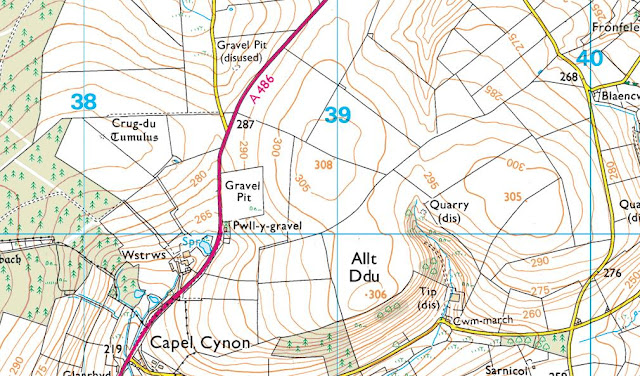%20-%201%2025000.jpg) |
| Extract from the Ordnance Survey 1:25,000 Explorer map |
However, it was not until LIDAR became available that the details for this hill could be accurately re-assessed. The LIDAR (Light Detection & Ranging) technique produced highly accurate height data that is now freely available for much of England and Wales.
LIDAR analysis gives the highest ground on this hill as 309.1m positioned at SN 38967 50318. However, this is a part of a raised field boundary and protocols dictate that as this is deemed a relatively recent man-made construct such ground is discounted from the height of a hill.
%20-%20LIDAR%20summit%201.jpg) |
| LIDAR summit image of Wstrws (SN 389 502) |
The height produced by LIDAR analysis to the natural summit of this hill is 308.2m positioned at SN 38955 50296, and this position in relation to the raised field boundary comes within the parameters of the Summit Relocations used within this page heading, these parameters are:
The term Summit Relocations applies when the high point of the hill is found to be positioned; in a different field, to a different feature such as in a conifer plantation, within a different map contour, to a different point where a number of potential summit positions are within close proximity, when natural ground or the natural and intact summit of a hill is confirmed compared to a higher point such as a raised field boundary or covered reservoir that is considered a relatively recent man-made construct, or a relocation of approximately 100 metres or more in distance from either the position of a map spot height or from where the summit of the hill was previously thought to exist.
Therefore, the summit height produced by LIDAR analysis is 308.2m and this is positioned at SN 38955 50296, this position is not given a spot height on the contemporary Ordnance Survey 1:25,000 Explorer map and is approximately 35 metres westward from where the 308m spot height appears on the Ordnance Survey 1:25,000 Explorer map and approximately 22 metres south-westward from the high point of the raised field boundary.
The full details for the hill are:
Group: Mynydd Bach
Name: Wstrws
OS 1:50,000 map: 145
Summit Height: 308.2m (LIDAR)
Summit Grid Reference (New Position): SN 38955 50296 (LIDAR)
Bwlch Height: 286.3m (LIDAR)
Bwlch Grid Reference: SN 38557 50449 (LIDAR)
Drop: 21.9m (LIDAR)
Myrddyn Phillips (January 2024)
Mapping Mountains - Summit Relocations - Y Trichant
Pen Moel Hedog (SN 451 469) - 45th summit relocation
Hill Reclassifications post for Pen Moel Hedog
There has been a Summit Relocation to a hill that is listed in the Y Trichant – The 300m Hills of Wales, with the summit height, bwlch height and their locations, the drop and status of the hill derived from LIDAR analysis conducted by Myrddyn Phillips.
%20-%20LIDAR%20hill%202.jpg) |
| LIDAR image of Pen Moel Hedog (SN 451 469) |
The criteria for the list that this summit relocation applies to are:
 |
| Y Trichant - The 300m Hills of Wales by Myrddyn Phillips |
The name the hill is listed by is Pen Moel Hedog, and it is adjoined to the Mynydd Bach group of hills, which are situated in the western part of South Wales (Region B, Sub-Region B1), and it is positioned with the B4459 road to its west, the A475 road to its south and a minor road to its east, and has the town of Llanybydder towards the east south-east.
When the original 300m height band of Welsh P30 hills were published on Geoff Crowder’s v-g.me website, this hill was not included in the Hills to be surveyed sub list, as it was considered not to meet the criteria then used for this sub category.
After the sub list was standardised, and interpolated heights and drop values also included the details for this hill were re-evaluated and it was listed with an estimated c 23m of drop, based on the 314m summit spot height positioned at SN 45142 46935 that appears on the contemporary Ordnance Survey 1:25,000 Explorer map, and an estimated c 291m bwlch height, based on interpolation of 5m contouring between 290m – 295m.
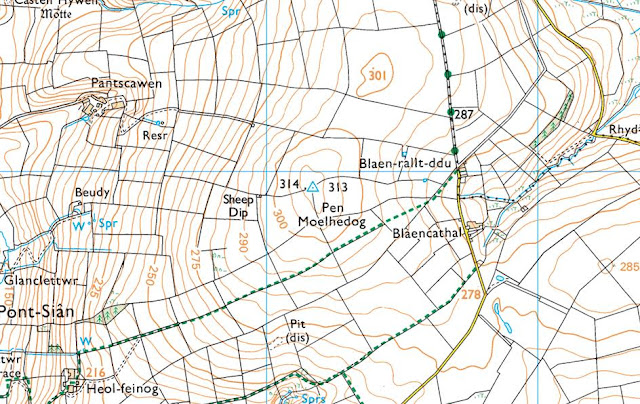%20-%201%2025000.jpg) |
| Extract from the Ordnance Survey 1:25,000 Explorer map |
However, it was not until LIDAR became available that the details for this hill could be accurately re-assessed. The LIDAR (Light Detection & Ranging) technique produced highly accurate height data that is now freely available for much of England and Wales.
LIDAR analysis gives the highest ground on this hill as 313.5m positioned at SN 45168 46943. However, this is a part of a raised field boundary and protocols dictate that as this is deemed a relatively recent man-made construct such ground is discounted from the height of a hill.
%20-%20LIDAR%20summit%202.jpg) |
| LIDAR summit image of Pen Moel Hedog (SN 451 469) |
The height produced by LIDAR analysis to the natural summit of this hill is 312.8m positioned at SN 45159 46968, and this position in relation to the raised field boundary comes within the parameters of the Summit Relocations used within this page heading, these parameters are:
The term Summit Relocations applies when the high point of the hill is found to be positioned; in a different field, to a different feature such as in a conifer plantation, within a different map contour, to a different point where a number of potential summit positions are within close proximity, when natural ground or the natural and intact summit of a hill is confirmed compared to a higher point such as a raised field boundary or covered reservoir that is considered a relatively recent man-made construct, or a relocation of approximately 100 metres or more in distance from either the position of a map spot height or from where the summit of the hill was previously thought to exist.
Therefore, the summit height produced by LIDAR analysis is 312.8m and this is positioned at SN 45159 46968, this position is not given a spot height on the contemporary Ordnance Survey 1:50,000 Landranger and 1:25,000 Explorer map and is approximately 35 metres north-eastward from where the 314m spot height appears on the Ordnance Survey 1:25,000 Explorer map and approximately 25 metres north north-westward from the high point of the raised field boundary.
The full details for the hill are:
Group: Mynydd Bach
Name: Pen Moel Hedog
OS 1:50,000 map: 146
Summit Height: 312.8m (LIDAR)
Summit Grid Reference (New Position): SN 45159 46968 (LIDAR)
Bwlch Height: 289.8m (LIDAR)
Bwlch Grid Reference: SN 45622 48279 (LIDAR)
Drop: 23.0m (LIDAR)
Myrddyn Phillips (January 2024)
Mapping Mountains - Summit Relocations - Y Trichant
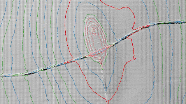
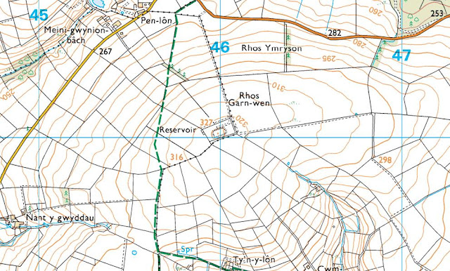
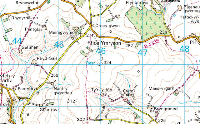
Rhos Ymryson (SN 460 499) - 44th summit relocation
Significant Height Revisions post for Rhos Ymryson
There has been a Summit Relocation to a hill that is listed in the Y Trichant – The 300m Hills of Wales and Y Trechol – The Dominant Hills of Wales, with the summit height, bwlch height and their locations, the drop and status of the hill derived from LIDAR analysis conducted by Myrddyn Phillips.
%20-%20LIDAR%20summit%205.jpg) |
| LIDAR image of Rhos Ymryson (SN 460 499) |
The criteria for the two listings that this summit relocation applies to are:
 |
| Y Trichant - The 300m Hills of Wales by Myrddyn Phillips |
 |
| Y Trechol - The Dominant Hills of Wales by Myrddyn Phillips |
The name the hill is listed by is Rhos Ymryson, and it is adjoined to the Mynydd Bach group of hills, which are situated in the western part of South Wales (Region B, Sub-Region B1), and it is positioned with the B4338 road to its north-east, a minor road to its north-west and the A475 road to its south, and has the village of Llanwenog towards the south-east.
%20-%201%2025000.jpg) |
| Extract from the Ordnance Survey 1:25,000 Explorer map |
%20-%201%2050000.jpg) |
| Extract from the Ordnance Survey 1:50,000 Landranger map |
When the original 300m height band of Welsh P30 hills were published on Geoff Crowder’s v-g.me website, this hill was included in the main P30 list with a 327m summit height, based on the spot height that appears on the contemporary Ordnance Survey 1:25,000 Explorer map and which is positioned at SN 459 500. However, this height is given to the top of a covered reservoir, whilst the contemporary Ordnance Survey 1:50,000 Landranger map gives a 324m summit spot height, which conforms with the rounded up 1062ft (323.7m) height shown on the Ordnance Surveys series of Six-Inch maps.
%20-%20Six-Inch.jpg) |
| Extract from the Ordnance Survey series of Six-Inch maps |
However, it was not until LIDAR became available that the details for this hill could be accurately re-assessed. The LIDAR (Light Detection & Ranging) technique produced highly accurate height data that is now freely available for much of England and Wales.
LIDAR analysis gives the highest ground on this hill as 326.6m positioned at SN 45999 50009. However, this is to the top of a covered reservoir and protocols dictate that as this is deemed a relatively recent man-made construct such ground is discounted from the height of a hill.
%20-%20LIDAR%20summit%201.jpg) |
| LIDAR summit image of Rhos Ymryson (SN 460 499) |
The height produced by LIDAR analysis to the highest remaining natural ground on this hill is 323.3m and is positioned at SN 46032 49996, and this position in relation to the covered reservoir comes within the parameters of the Summit Relocations used within this page heading, these parameters are:
The term Summit Relocations applies when the high point of the hill is found to be positioned; in a different field, to a different feature such as in a conifer plantation, within a different map contour, to a different point where a number of potential summit positions are within close proximity, when natural ground or the natural and intact summit of a hill is confirmed compared to a higher point such as a raised field boundary or covered reservoir that is considered a relatively recent man-made construct, or a relocation of approximately 100 metres or more in distance from either the position of a map spot height or from where the summit of the hill was previously thought to exist.
Therefore, the summit height produced by LIDAR analysis is 323.3m and this is positioned at SN 46032 49996, this position is not given a spot height on the contemporary Ordnance Survey 1:25,000 Explorer map, but is given a 324m spot height on the contemporary 1:50,000 Landranger map, and is approximately 33 metres east south-eastward from the high point of the covered reservoir.
The full details for the hill are:
Group: Mynydd Bach
Name: Rhos Ymryson
OS 1:50,000 map: 146
Summit Height: 323.3m (LIDAR)
Summit Grid Reference (New Position): SN 46032 49996 (LIDAR)
Bwlch Height: 162.6m (LIDAR)
Bwlch Grid Reference: SN 61745 57992 (LIDAR)
Drop: 160.8m (LIDAR)
Dominance: 49.72% (LIDAR)
Myrddyn Phillips (January 2024)
Mapping Mountains - Summit Relocations - Y Trichant
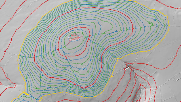
Rhos Garn Whilgarn (SN 451 517) - 43rd summit relocation
There has been a Summit Relocation to a hill that is listed in the Y Trichant – The 300m Hills of Wales, with the summit height, bwlch height and their locations, the drop and status of the hill derived from LIDAR analysis conducted by Myrddyn Phillips.
%20-%20LIDAR%20hill%201.jpg) |
| LIDAR image of Rhos Garn Whilgarn (SN 451 517) |
The criteria for the list that this summit relocation applies to are:
 |
| Y Trichant - The 300m Hills of Wales by Myrddyn Phillips |
The name the hill is listed by is Rhos Garn Whilgarn, and it is adjoined to the Mynydd Bach group of hills, which are situated in the western part of South Wales (Region B, Sub-Region B1), and it is positioned with a minor road to its west and east, and the B4338 road to its south-west, and has the village of Post-mawr (Synod Inn) towards the north-west.
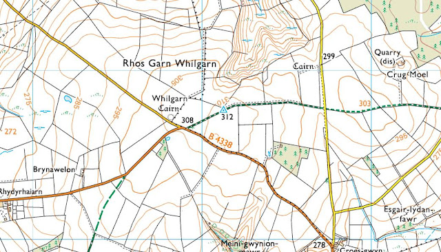%20-%201%2025000.jpg) |
| Extract from the Ordnance Survey 1:25,000 Explorer map |
However, it was not until LIDAR became available that the details for this hill could be accurately re-assessed. The LIDAR (Light Detection & Ranging) technique produced highly accurate height data that is now freely available for much of England and Wales.
LIDAR analysis gives the highest ground on this hill as 313.1m positioned at SN 45149 51777. However, this is a part of a raised field boundary and protocols dictate that as this is deemed a relatively recent man-made construct such ground is discounted from the height of a hill.
%20-%20LIDAR%20summit%203.jpg) |
| LIDAR summit image of Rhos Garn Whilgarn (SN 451 517) |
The height produced by LIDAR analysis to the natural summit of this hill is 312.1m positioned at SN 45127 51754, and this position in relation to the raised field boundary comes within the parameters of the Summit Relocations used within this page heading, these parameters are:
The term Summit Relocations applies when the high point of the hill is found to be positioned; in a different field, to a different feature such as in a conifer plantation, within a different map contour, to a different point where a number of potential summit positions are within close proximity, when natural ground or the natural and intact summit of a hill is confirmed compared to a higher point such as a raised field boundary or covered reservoir that is considered a relatively recent man-made construct, or a relocation of approximately 100 metres or more in distance from either the position of a map spot height or from where the summit of the hill was previously thought to exist.
Therefore, the summit height produced by LIDAR analysis is 312.1m and this is positioned at SN 45127 51754, this position is not given a spot height on the contemporary Ordnance Survey 1:50,000 Landranger and 1:25,000 Explorer map and is approximately 23 metres south-westward from where the high point of the raised field boundary is positioned and approximately 10 metres south-eastward from where the triangulation pillar is positioned, which is also situated on the same raised field boundary.
The full details for the hill are:
Group: Mynydd Bach
Name: Rhos Garn Whilgarn
OS 1:50,000 map: 146
Summit Height: 312.1m (LIDAR)
Summit Grid Reference (New Position): SN 45127 51754 (LIDAR)
Bwlch Height: 273.3m (LIDAR)
Bwlch Grid Reference: SN 45739 50729 (LIDAR)
Drop: 38.8m (LIDAR)
Myrddyn Phillips (January 2024)
Mapping Mountains - Summit Relocations - Y Trichant
Trichrug (SN 541 599) - 42nd summit relocation
There has been a Summit Relocation to a hill that is listed in the Y Trichant – The 300m Hills of Wales, with the summit height, bwlch height and their locations, the drop and status of the hill derived from LIDAR analysis conducted by Myrddyn Phillips.
%20-%20new%20LIDAR%20summit%205.jpg) |
| LIDAR image of Trichrug (SN 541 599) |
The criteria for the list that this summit relocation applies to are:
 |
| Y Trichant - The 300m Hills of Wales by Myrddyn Phillips |
The name the hill is listed by is Trichrug and it is adjoined to the Mynydd Bach group of hills, which are situated in the western part of South Wales (Region B, Sub-Region B1), and it is positioned with minor roads to its north-west and south-west, and the B4337 road to its immediate east, and has the town of Aberaeron towards the west north-west.
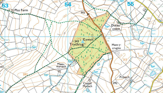%20-%201%2025000%20screen%20grab.jpg) |
| Extract from the Ordnance Survey 1:25,000 Explorer map |
However, it was not until LIDAR became available that the details for this hill could be accurately re-assessed. The LIDAR (Light Detection & Ranging) technique produced highly accurate height data that is now freely available for much of England and Wales.
%20-%20new%20LIDAR%20summit%202.jpg) |
| LIDAR summit image of Trichrug (SN 541 599) |
LIDAR analysis gives the highest ground on this hill as 344.35m positioned at SN 54196 59952, and this in relation to the previously listed summit position comes within the parameters of the Summit Relocations used within this page heading, these parameters are:
The term Summit Relocations applies when the high point of the hill is found to be positioned; in a different field, to a different feature such as in a conifer plantation, within a different map contour, to a different point where a number of potential summit positions are within close proximity, when natural ground or the natural and intact summit of a hill is confirmed compared to a higher point such as a raised field boundary or covered reservoir that is considered a relatively recent man-made construct, or a relocation of approximately 100 metres or more in distance from either the position of a map spot height or from where the summit of the hill was previously thought to exist.
Therefore, the summit height produced by LIDAR analysis is 344.35m and this is positioned at SN 54196 59952, this position is not given a spot height on the contemporary Ordnance Survey 1:50,000 Landranger and the 1:25,000 Explorer map, and is approximately 38 metres north-westward from where the previously listed summit is positioned and importantly positioned on a different tumulus which qualifies under the different feature protocol.
The full details for the hill are:
Group: Mynydd Bach
Name: Trichrug
OS 1:50,000 map: 146
Summit Height: 344.35m (LIDAR)
Summit Grid Reference (New Position): SN 54196 59952 (LIDAR)
Bwlch Height: 270.1m (LIDAR)
Bwlch Grid Reference: SN 57812 61942 (LIDAR)
Drop: 74.3m (LIDAR)
Myrddyn Phillips (December 2023)
Mapping Mountains - Summit Relocations - Y Trichant
Cymanfynydd Fach (SN 562 615) - 41st summit relocation
Significant Name Changes post for Cymanfynydd Fach
There has been a Summit Relocation to a hill that is listed in the Y Trichant – The 300m Hills of Wales, with the summit height, bwlch height and their locations, the drop and status of the hill derived from LIDAR analysis conducted by Myrddyn Phillips.
%20-%20new%20LIDAR%20hill%203.jpg) |
| LIDAR image of Cymanfynydd Fach (SN 562 615) |
The criteria for the list that this summit relocation applies to are:
 |
| Y Trichant - The 300m Hills of Wales by Myrddyn Phillips |
The name the hill is listed by is Cymanfynydd Fach and this was derived from the Tithe map, with research conducted by Iwan Wmffre for the composition of this name with his work detailed in the books entitled The Place-Names of Cardiganshire published by the British Archaeological Reports Oxford Ltd, and it is adjoined to the Mynydd Bach group of hills, which are situated in the western part of South Wales (Region B, Sub-Region B1), and it is positioned encircled by minor roads, with the B4577 road farther to its north, the B4337 road farther to its west, the B4342 road farther to its south and the B4576 road farther to its east, and has the town of Aberaeron towards the west.
%20-%201%2025000%20screen%20grab.jpg) |
| Extract from the Ordnance Survey 1:25,000 Explorer map |
However, it was not until LIDAR became available that the details for this hill could be accurately re-assessed. The LIDAR (Light Detection & Ranging) technique produced highly accurate height data that is now freely available for much of England and Wales.
LIDAR analysis gives the highest ground on this hill as 316.2m positioned at SN 56277 61518. However, this is a part of a raised field boundary and protocols dictate that as this is deemed a relatively recent man-made construct such ground is discounted from the height of a hill.
%20-%20new%20LIDAR%20summit%203.jpg) |
| LIDAR summit image of Cymanfynydd Fach (SN 562 615) |
The height produced by LIDAR analysis to the highest remaining natural ground of this hill is 315.6m positioned at SN 56285 61520, and this position in relation to the raised field boundary comes within the parameters of the Summit Relocations used within this page heading, these parameters are:
The term Summit Relocations applies when the high point of the hill is found to be positioned; in a different field, to a different feature such as in a conifer plantation, within a different map contour, to a different point where a number of potential summit positions are within close proximity, when natural ground or the natural and intact summit of a hill is confirmed compared to a higher point such as a raised field boundary or covered reservoir that is considered a relatively recent man-made construct, or a relocation of approximately 100 metres or more in distance from either the position of a map spot height or from where the summit of the hill was previously thought to exist.
Therefore, the summit height produced by LIDAR analysis is 315.6m and this is positioned at SN 56285 61520, this position is close to where the 316m spot height appears on the contemporary Ordnance Survey 1:50,000 Landranger and the 1:25,000 Explorer map, and is approximately 8 metres eastward from where the high point of the raised field boundary is positioned.
The full details for the hill are:
Group: Mynydd Bach
Name: Cymanfynydd Fach
OS 1:50,000 map: 146
Summit Height: 315.6m (LIDAR)
Summit Grid Reference (New Position): SN 56285 61520 (LIDAR)
Bwlch Height: 274.95m (LIDAR)
Bwlch Grid Reference: SN 55869 60212 (LIDAR)
Drop: 40.7m (LIDAR)
Myrddyn Phillips (December 2023)
Mapping Mountains - Summit Relocations - Y Trichant
Pt. 329.7m (SN 591 630) - 40th summit relocation
Hill Reclassifications post for Pt. 329.7m
Significant Height Revisions post for Pt. 329.7m
There has been a Summit Relocation to a hill that is listed in the Y Trichant – The 300m Hills of Wales, with the summit height, bwlch height and their locations, the drop and status of the hill derived from LIDAR analysis conducted by Myrddyn Phillips.
%20-%20LIDAR%20hill%201.jpg) |
| LIDAR image of Pt. 329.7m (SN 591 630) |
The criteria for the list that this summit relocation applies to are:
 |
| Y Trichant - The 300m Hills of Wales by Myrddyn Phillips |
The hill is being listed by the point (Pt. 329.7m) notation and it is adjoined to the Mynydd Bach group of hills, which are situated in the western part of South Wales (Region B, Sub-Region B1), and it is positioned with the B4576 road to its north-west, B4577 road to its south and a minor road to its east, and has the village of Llangeitho towards the south-east.
After the sub list was standardised, and interpolated heights and drop values also included the details for this hill were re-evaluated and it was listed with an estimated c 20m of drop, based on an estimated c 327m summit height and an estimated c 307m bwlch height, with both heights based on interpolation of 5m contouring that appeared on the Ordnance Survey Vector Map Local hosted on the Geograph website and which was entitled the Interactive Coverage Map.
%20-%201%2025000.jpg) |
| Extract from the Ordnance Survey 1:25,000 Explorer map |
Since the original publication of the Welsh P30 lists on Geoff Crowder’s v-g.me website there have been a number of maps made available online. Some of these are historic such as the series of Six-Inch maps on the National Library of Scotland website. Whilst others were digitally updated such as the Ordnance Survey Vector Map Local that was hosted on the Geograph website and which was entitled the Interactive Coverage Map, whilst others are current and digitally updated such as the interactive mapping on the Magic Maps and WalkLakes websites.
One of the mapping resources now available online is on the Magic Maps website which hosts an interactive map originated from Ordnance Survey data. Until recently this mapping had many spot heights not on other publicly available maps and for this hill it had a 327m spot height on the summit area of this hill and positioned at SN 59019 63010, resulting in its details being amended accordingly.
%20IMG_0084A%20-%20Magic%20Maps.jpg) |
| Extract from the interactive mapping hosted on the Magic Maps website |
However, it was not until LIDAR became available that the details for this hill could be accurately re-assessed. The LIDAR (Light Detection & Ranging) technique produced highly accurate height data that is now freely available for much of England and Wales.
%20-%20LIDAR%20summit%202.jpg) |
| LIDAR summit image of Pt. 329.7m (SN 591 630) |
LIDAR analysis gives the highest ground on this hill as 329.7m positioned at SN 59108 63024, and this in relation to the previously listed summit position comes within the parameters of the Summit Relocations used within this page heading, these parameters are:
The term Summit Relocations applies when the high point of the hill is found to be positioned; in a different field, to a different feature such as in a conifer plantation, within a different map contour, to a different point where a number of potential summit positions are within close proximity, when natural ground or the natural and intact summit of a hill is confirmed compared to a higher point such as a raised field boundary or covered reservoir that is considered a relatively recent man-made construct, or a relocation of approximately 100 metres or more in distance from either the position of a map spot height or from where the summit of the hill was previously thought to exist.
Therefore, the summit height produced by LIDAR analysis is 329.7m and this is positioned at SN 59108 63024, this position is not given a spot height on the contemporary Ordnance Survey 1:50,000 Landranger and the 1:25,000 Explorer map, and is approximately 90 metres eastward from where the previously listed summit is positioned which was based on the 327m spot height that appeared on the interactive mapping hosted on the Magic Maps website, and importantly the summit is positioned to a different feature.
The full details for the hill are:
Group: Mynydd Bach
Name: Pt. 329.7m
OS 1:50,000 map: 146
Summit Height: 329.7m (LIDAR)
Summit Grid Reference (New Position): SN 59108 63024 (LIDAR)
Bwlch Height: 306.9m (LIDAR)
Bwlch Grid Reference: SN 59361 63409 & SN 59359 63413 (LIDAR)
Drop: 22.8m (LIDAR)
Myrddyn Phillips (November 2023)
Mapping Mountains - Summit Relocations - Y Trichant
Mynydd Llanfynydd (SN 545 286) - 39th summit relocation
Significant Name Changes post for Mynydd Llanfynydd
There has been a Summit Relocation to a hill that is listed in the Y Trichant – The 300m Hills of Wales, with the summit height, bwlch height and their locations, the drop and status of the hill derived from LIDAR analysis conducted by Myrddyn Phillips.
%20-%20LIDAR%20hill%201.jpg) |
| LIDAR image of Mynydd Llanfynydd (SN 545 286) |
The criteria for the list that this summit relocation applies to are:
 |
| Y Trichant - The 300m Hills of Wales by Myrddyn Phillips |
The name the hill is now listed by is Mynydd Llanfynydd and this was derived from the Tithe map, and it is adjoined to the Mynydd Mallaen group of hills, which are situated in the central part of South Wales (Region B, Sub-Region B1), and it is positioned with minor roads to its west and east, and the B4310 road to its north-west, and has the village of Brechfa towards the north-west.
%20-%201%2025000.jpg) |
| Extract from the Ordnance Survey 1:25,000 Explorer map |
However, it was not until LIDAR became available that the details for this hill could be accurately re-assessed. The LIDAR (Light Detection & Ranging) technique produced highly accurate height data that is now freely available for much of England and Wales.
LIDAR analysis gives the highest ground on this hill as 326.1m positioned at SN 54584 28615. However, this is a part of a raised field boundary and protocols dictate that as this is deemed a relatively recent man-made construct such ground is discounted from the height of a hill.
%20-%20LIDAR%20summit%203.jpg) |
| LIDAR summit image of Mynydd Llanfynydd (SN 545 286) |
The height produced by LIDAR analysis to the natural summit of this hill is 325.6m positioned at SN 54561 28617, and this position in relation to the raised field boundary comes within the parameters of the Summit Relocations used within this page heading, these parameters are:
The term Summit Relocations applies when the high point of the hill is found to be positioned; in a different field, to a different feature such as in a conifer plantation, within a different map contour, to a different point where a number of potential summit positions are within close proximity, when natural ground or the natural and intact summit of a hill is confirmed compared to a higher point such as a raised field boundary or covered reservoir that is considered a relatively recent man-made construct, or a relocation of approximately 100 metres or more in distance from either the position of a map spot height or from where the summit of the hill was previously thought to exist.
Therefore, the summit height produced by LIDAR analysis is 325.6m and this is positioned at SN 54561 28617, this position is not given a spot height on the contemporary Ordnance Survey 1:50,000 Landranger and the 1:25,000 Explorer map, and is approximately 23 metres eastward from where the high point of the raised field boundary is positioned and approximately 65 metres north-westward from where the triangulation pillar is positioned.
The full details for the hill are:
Group: Mynydd Mallaen
Name: Mynydd Llanfynydd
OS 1:50,000 map: 146
Summit Height: 325.6m (LIDAR)
Summit Grid Reference (New Position): SN 54561 28617 (LIDAR)
Bwlch Height: 245.05m (LIDAR)
Bwlch Grid Reference: SN 57145 30251 (LIDAR)
Drop: 80.5m (LIDAR)
Myrddyn Phillips (September 2023)
Mapping Mountains - Summit Relocations - Y Trichant
Pen Llwyn Uchel (SN 517 387) - 38th summit relocation
Significant Height Revisions post for Pen Llwyn Uchel
Significant Name Changes post for Pen Llwyn Uchel
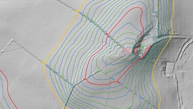
There has been a Summit Relocation to a hill that is listed in the Y Trichant – The 300m Hills of Wales, with the summit height, bwlch height and their locations, the drop and status of the hill derived from LIDAR analysis conducted by Myrddyn Phillips.
%20-%20New%20LIDAR%20hill%203.jpg) |
| LIDAR image of Pen Llwyn Uchel (SN 517 387) |
The criteria for the list that this summit relocation applies to are:
 |
| Y Trichant - The 300m Hills of Wales by Myrddyn Phillips |
The name the hill is listed by is Pen Llwyn Uchel and it is adjoined to the Mynydd Pencarreg group of hills, which are situated in the south-western part of South Wales (Region B, Sub-Region B1), and it is positioned with a minor road to its immediate north, the A485 road to its west and the B4337 road to its east, and has the town of Llanybydder towards the north.
%20-%20New%201%2025000.jpg) |
| Extract from the Ordnance Survey 1:25,000 Explorer map |
When the original 300m height band of Welsh P30 hills were published on Geoff Crowder’s v-g.me website, this hill was included in the accompanying Hills to be surveyed sub list with a 381m summit height, based on the twin 381m spot heights that appear on the Ordnance Survey 1:25,000 Explorer map, with the prioritised summit positioned at SN 512 383 and with an accompanying note stating; Two tops of same height (SN517388 is 383m on 1985 1:50000 map).
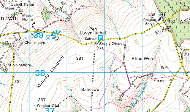%20-%20New%201%2050000.jpg) |
| Extract from the Ordnance Survey 1:50,000 Landranger map |
However, it was not until LIDAR became available that the details for this hill could be accurately re-assessed. The LIDAR (Light Detection & Ranging) technique produced highly accurate height data that is now freely available for much of England and Wales.
%20-%20New%20LIDAR%20hill%201.jpg) |
| LIDAR summit image of Pen Llwyn Uchel (SN 517 387) |
The summit height produced by LIDAR analysis is 383.45m positioned at SN 51750 38783 and SN 51757 38784, with LIDAR giving 380.7m positioned at SN 51229 38380 for the old prioritised summit, and this comes within the parameters of the Summit Relocations used within this page heading, these parameters are:
The term Summit Relocations applies when the high point of the hill is found to be positioned; in a different field, to a different feature such as in a conifer plantation, within a different map contour, to a different point where a number of potential summit positions are within close proximity, when natural ground or the natural and intact summit of a hill is confirmed compared to a higher point such as a raised field boundary or covered reservoir that is considered a relatively recent man-made construct, or a relocation of approximately 100 metres or more in distance from either the position of a map spot height or from where the summit of the hill was previously thought to exist.
Therefore, the summit height produced by LIDAR analysis is 383.45m and this is positioned at SN 51750 38783 and SN 51757 38784, this position is given a 381m spot height on the contemporary Ordnance Survey 1:25,000 Explorer map and a 383m spot height on the contemporary Ordnance Survey 1:50,000 Landranger map, and is approximately 550 metres north-eastward from where the origin prioritised summit is positioned.
The full details for the hill are:
Group: Mynydd Pencarreg
Name: Pen Llwyn Uchel
OS 1:50,000 map: 146
Summit Height: 383.45m (LIDAR)
Summit Grid Reference (New Position): SN 51750 38783 & SN 51757 38784 (LIDAR)
Bwlch Height: 359.6m (LIDAR)
Bwlch Grid Reference: SN 52370 38728 (LIDAR)
Drop: 23.8m (LIDAR)
Myrddyn Phillips (September 2023)
Mapping Mountains - Summit Relocations - Y Trichant
Tyn y Waun (SN 679 386) - 37th summit relocation
Significant Name Changes post for Tyn y Waun
There has been a Summit Relocation to a hill that is listed in the Y Trichant – The 300m Hills of Wales, with the summit height, bwlch height and their locations, the drop and status of the hill derived from LIDAR analysis conducted by Myrddyn Phillips.
%20-%20LIDAR%20hill%201.jpg) |
| LIDAR image of Tyn y Waun (SN 679 386) |
The criteria for the list that this summit relocation applies to are:
 |
| Y Trichant - The 300m Hills of Wales by Myrddyn Phillips |
The name the hill is now listed by is Tyn y Waun and this was derived from the Tithe map, and it is adjoined to the Mynydd Mallaen group of hills, which are situated in the central part of South Wales (Region B, Sub-Region B1), and it is positioned with minor roads to its north, west and east, and the A482 road to its south, and has the town of Llanymddyfri (Llandovery) towards the east south-east.
When the original 300m height band of Welsh P30 hills were published on Geoff Crowder’s v-g.me website, this hill was included in the main P30 list with a 311m summit height, based on the spot height adjoined to a triangulation pillar that appears on the Ordnance Survey 1:50,000 Landranger and 1:25,000 Explorer map and which is positioned at SN 67953 38615.
%20-%201%2025000.jpg) |
| Extract from the Ordnance Survey 1:25,000 Explorer map |
However, it was not until LIDAR became available that the details for this hill could be accurately re-assessed. The LIDAR (Light Detection & Ranging) technique produced highly accurate height data that is now freely available for much of England and Wales.
%20-%20LIDAR%20summit%204.jpg) |
| LIDAR summit image of Tyn y Waun (SN 679 386) |
LIDAR analysis gives the highest ground on this hill as 311.5m positioned at SN 67956 38618. However, this is a part of a raised field boundary and protocols dictate that as this is deemed a relatively recent man-made construct such ground is discounted from the height of a hill.
%20-%20LIDAR%20summit%202.jpg) |
| LIDAR close up summit image of Tyn y Waun (SN 679 386) |
The height produced by LIDAR analysis to the natural summit of this hill is 311.2m positioned at SN 67962 38620, and this position in relation to the raised field boundary comes within the parameters of the Summit Relocations used within this page heading, these parameters are:
The term Summit Relocations applies when the high point of the hill is found to be positioned; in a different field, to a different feature such as in a conifer plantation, within a different map contour, to a different point where a number of potential summit positions are within close proximity, when natural ground or the natural and intact summit of a hill is confirmed compared to a higher point such as a raised field boundary or covered reservoir that is considered a relatively recent man-made construct, or a relocation of approximately 100 metres or more in distance from either the position of a map spot height or from where the summit of the hill was previously thought to exist.
Therefore, the summit height produced by LIDAR analysis is 311.2m and this is positioned at SN 67962 38620, this position is close to where the 311m spot height appears on the contemporary Ordnance Survey 1:50,000 Landranger and 1:25,000 Explorer map, and is approximately six metres north-eastward from where the high point of the raised field boundary is positioned.
The full details for the hill are:
Group: Mynydd Mallaen
Name: Tyn y Waun
OS 1:50,000 map: 146
Summit Height: 311.2m (LIDAR)
Summit Grid Reference (New Position): SN 67962 38620 (LIDAR)
Bwlch Height: 244.6m (LIDAR)
Bwlch Grid Reference: SN 68595 39591 (LIDAR)
Drop: 66.6m (LIDAR)
Myrddyn Phillips (September 2023)
Mapping Mountains - Summit Relocations - Y Trichant
Pant y Fyda (SN 562 361) - 36th summit relocation
Significant Name Changes post for Pant y Fyda
There has been a Summit Relocation to a hill that is listed in the Y Trichant – The 300m Hills of Wales, with the summit height, bwlch height and their locations, the drop and status of the hill derived from detail on contemporary maps produced from Ordnance Survey data and LIDAR analysis conducted by Myrddyn Phillips.
%20-%20LIDAR%20summit%203.jpg) |
| LIDAR image of Pant y Fyda (SN 562 361) |
The criteria for the list that this summit relocation applies to are:
Y Trichant – The 300m Hills of Wales – Welsh hills at or above 300m and below 400m in height that have 30m minimum drop, with an accompanying sub list entitled the Sub-Trichant, with the criteria for this sub category being all Welsh hills at or above 300m and below 400m in height with 20m or more and below 30m of drop. The list is authored by Myrddyn Phillips with the Introduction to the list and the renaming of it appearing on Mapping Mountains on the 13th May 2017, and the Introduction to the Mapping Mountains publication of the list appearing on the 1st January 2022.
 |
| Y Trichant - The 300m Hills of Wales by Myrddyn Phillips |
The name the hill is now listed by is Pant y Fyda, and it is adjoined to the Mynydd Pencarreg group of hills, which are situated in the south-western part of South Wales (Region B, Sub-Region B1), and it is positioned with minor roads to its north and west, the B4310 road to its south-east and the B4337 road to its north-east, and has the village of Llansawel towards the east.
%20IMG_9876A%20-%201%2025000.jpg) |
| Extract from the Ordnance Survey 1:25,000 Explorer map |
However, it was not until LIDAR became available that the details for this hill could be accurately re-assessed. The LIDAR (Light Detection & Ranging) technique produced highly accurate height data that is now freely available for much of England and Wales.
LIDAR analysis gives the highest ground on this hill as 322.1m positioned at SN 56283 36132 and SN 56286 36133. However, this is a part of a raised water tank and protocols dictate that as this is deemed a relatively recent man-made construct such ground is discounted from the height of a hill.
%20-%20LIDAR%20summit%201.jpg) |
| LIDAR summit image of Pant y Fyda (SN 562 361) |
The height produced by LIDAR analysis to the natural summit of this hill is 321.4m positioned at SN 56293 36166, and this position in relation to the raised water tank comes within the parameters of the Summit Relocations used within this page heading, these parameters are:
The term Summit Relocations applies when the high point of the hill is found to be positioned; in a different field, to a different feature such as in a conifer plantation, within a different map contour, to a different point where a number of potential summit positions are within close proximity, when natural ground or the natural and intact summit of a hill is confirmed compared to a higher point such as a raised field boundary or covered reservoir that is considered a relatively recent man-made construct, or a relocation of approximately 100 metres or more in distance from either the position of a map spot height or from where the summit of the hill was previously thought to exist.
Therefore, the summit height produced by LIDAR analysis is 321.4m and this is positioned at SN 56293 36166, this position is not given a spot height on the contemporary Ordnance Survey 1:50,000 Landranger and the 1:25,000 Explorer map, and is approximately 35 metres northward from where the high point of the raised water tank is positioned.
The full details for the hill are:
Group: Mynydd Pencarreg
Name: Pant y Fyda
OS 1:50,000 map: 146
Summit Height: 321.4m (LIDAR)
Summit Grid Reference (New Position): SN 56293 36166 (LIDAR)
Bwlch Height: c 287m (interpolation)
Bwlch Grid Reference: SN 55727 36635 (interpolation)
Drop: c 34m (LIDAR summit and interpolated bwlch)
Myrddyn Phillips (August 2023)

%20-%20LIDAR%20hill%203.jpg)


%20-%201%2025000.jpg)
%20-%20Tithe.jpg)
%20-%20apportionments.jpg)
%20-%20LIDAR%20summit%202.jpg)

%20IMG_9876A%20-%201%2025000.jpg)
%20IMG_9880A%20-%20Tithe.jpg)
%20IMG_9888A%20-%20apportionments.jpg)

%20-%20LIDAR%20hill%202.jpg)

%20-%201%2025000.jpg)
%20-%20LIDAR%20summit%203.jpg)
%20-%20LIDAR%20hill%202.jpg)

%20-%201%2050000.jpg)
%20-%201%2025000.jpg)
%20-%20LIDAR%20summit%203.jpg)
%20-%20LIDAR%20hill%203.jpg)

%20-%201%2025000.jpg)
%20-%20LIDAR%20summit%202.jpg)
%20-%20LIDAR%20hill%204.jpg)

%20-%201%2025000.jpg)
%20-%20LIDAR%20summit%201.jpg)
%20-%20LIDAR%20hill%202.jpg)

%20-%201%2025000.jpg)
%20-%20LIDAR%20summit%201.jpg)
%20-%20LIDAR%20hill%202.jpg)

%20-%201%2025000.jpg)
%20-%20LIDAR%20summit%202.jpg)
%20-%20LIDAR%20summit%205.jpg)


%20-%201%2025000.jpg)
%20-%201%2050000.jpg)
%20-%20Six-Inch.jpg)
%20-%20LIDAR%20summit%201.jpg)
%20-%20LIDAR%20hill%201.jpg)

%20-%201%2025000.jpg)
%20-%20LIDAR%20summit%203.jpg)
%20-%20new%20LIDAR%20summit%205.jpg)

%20-%201%2025000%20screen%20grab.jpg)
%20-%20new%20LIDAR%20summit%202.jpg)
%20-%20new%20LIDAR%20hill%203.jpg)

%20-%201%2025000%20screen%20grab.jpg)
%20-%20new%20LIDAR%20summit%203.jpg)
%20-%20LIDAR%20hill%201.jpg)

%20-%201%2025000.jpg)
%20IMG_0084A%20-%20Magic%20Maps.jpg)
%20-%20LIDAR%20summit%202.jpg)
%20-%20LIDAR%20hill%201.jpg)

%20-%201%2025000.jpg)
%20-%20LIDAR%20summit%203.jpg)
%20-%20New%20LIDAR%20hill%203.jpg)

%20-%20New%201%2025000.jpg)
%20-%20New%201%2050000.jpg)
%20-%20New%20LIDAR%20hill%201.jpg)
%20-%20LIDAR%20hill%201.jpg)

%20-%201%2025000.jpg)
%20-%20LIDAR%20summit%204.jpg)
%20-%20LIDAR%20summit%202.jpg)
%20-%20LIDAR%20summit%203.jpg)

%20IMG_9876A%20-%201%2025000.jpg)
%20-%20LIDAR%20summit%201.jpg)