14.05.18 Foel (SH 632 045), Foel Cocyn (SH 624 042),
Foel Tyddyn y Berllan (SH 634 051), Gamallt (SH 665 067), Coed Uchaf (SH 649
055), Castell (SH 655 061), Pt. 230.2m (SH 648 063), Craig yr Aderyn (SH 647
065) and Craig yr Aderyn (SH 643 068)
 |
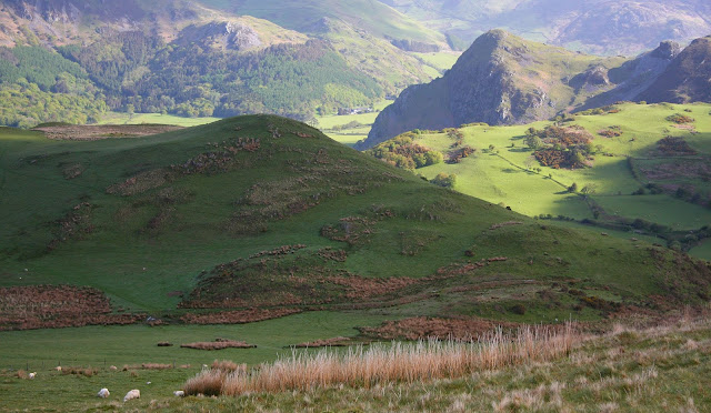
| Craig yr Aderyn with Cadair Idris as backdrop |
Rising above and to the
south of the flat bedded Dyffryn Dysynni is a small land mass enclosing a
number of individual hills, this land is topographically adjoined to the
Tarennydd, although on first view it extends from land adjoined to the hills of
Cadair Idris, with it only being separated by the Afon Dysynni.
I’d contemplated
visiting these hills for a number of years, but other hills (as they are prone)
had got in the way. However, after
producing a number of accurate heights for both summit and bwlch for these
hills via LIDAR analysis I thought it time that I visited, and with the weather
set fine I set off for Dolgoch; a small community on the southern side of these
hills.
I knew from LIDAR
analysis that two of the eight hills I planned on visiting were additions to
the Welsh 200m P30 list, and gathering data with the Trimble would no doubt
confirm this.
 |
| One of the new Welsh P30s - Foel Tyddyn y Berllan (SH 634 051) |
A short walk on the B
road brought me to the lower part of the first hill’s eastern ridge (the hill
is known locally by the farmer who grazes this land as Foel), this climbed
steadily upward bathed in the early morning’s sunshine with an old fence
following the ridge line and scattered sheep and their lambs contentedly
grazing.
 |
| The other new Welsh P30 - Foel (SH 632 045) |
As height was gained the
view opened, and to the north-east Cadair Idris rose highlighted in sunshine
with an unadulterated backdrop of delicate blue, the foreground was framed by
the hills I planned on visiting and surveying, one led to another, and all looked
inviting.
 |
| Cadair Idris |
Light and shade were
accentuated subtleties in shape and profile with the hills of Craig yr Aderyn
always drawing the eye, however nestled below this backdrop was the second new
P30, this is known locally as Foel Tyddyn y Berllan and its new status awaited confirmation
by the Trimble GeoXH 6000.
 |
| Foel Tyddyn y Berllan in shade with Craig yr Aderyn in the background |
The summit of Foel
consists of ground at the base of the ridge fence and within a few minutes of
arriving at the high point, the Trimble was positioned on top of a fence post
and the measurement offset taken from its internal antenna to the ground below.
 |
| Gathering data at the summit of Foel |
My second of eight hills
on this walk was also the highest and although named as Ffridd Cocyn on
Ordnance Survey maps it is known locally by the farmers who I spoke to as Foel
Cocyn, although I was surprised with this name it makes sense as a ffridd would
apply to an enclosed field and not the whole hill, whilst the term foel would
apply to the latter.
 |
| Foel Cocyn (SH 624 042) |
On my way to Foel Cocyn
was the connecting and critical bwlch for Foel, this proved to be positioned in
thick grass that merged with a section of reed grass, one shined green in the
sun, whilst the other swayed delicately in the morning’s breeze.
 |
| Gathering data at the critical bwlch of Foel |
A path led up the
eastern slopes of Foel Cocyn but I diverted from it when I saw a quad bike
heading up toward me from the north, Edward Cook was out with a colleague and
two sheep dogs and we talked for a number of minutes, he was the first farmer
that gave me the name of Foel Cocyn for the hill explaining that the word cocyn
refers to the small hummocks on the hill’s western slopes.
 |
| Edward Cook and colleague |
After a well-earned rest
during which the Trimble gathered its allotted data from the summit of Foel
Cocyn, I backtracked toward Foel and continued down from its connecting bwlch
heading northward to the bwlch connecting it with Foel Tyddyn y Berllan.
 |
| Gathering data at the summit of Foel Cocyn |
 |
| Foel Tyddyn y Berllan and Craig yr Aderyn |
After the bwlch survey I
headed to the summit which has a small and attractive rock outcrop as its high
point. As the Trimble gathered data I
stood and looked north-eastward toward Craig yr Aderyn, a marvellous view
bathed in crisp morning light with the constant backdrop of the iconic Cadair
Idris adding height and depth to the scene.
 |
| Gathering data at the summit of Foel Tyddyn y Berllan |
 |
| Castell and Coed Uchaf from Foel Tyddyn y Berllan |
By now the day’s warmth
was increasing in intensity and the route down toward the outskirts of the
small community of Abertrinant was eased with an earthen track leading to the
farm of Llanerch-goediog, where I met Stephen Jones whose hills I had just
visited and who gave me the name of Foel and Foel Tyddyn y Berllan, explaining
that Foel Wyllt, which is a name appearing near these hills on contemporary
Ordnance Survey maps, takes in the whole mountain, as in the whole land mass extending
south-westward above his farm.
 |
| Stephen Jones |
After noting the names
Stephen gave, I explained about the Trimble and asked if he minded me visiting
the adjacent field to survey the critical bwlch of Gamallt, which is a
prominent hill to the north-east and one whose summit would have to wait for another
day. Stephen directed me toward the
bwlch, telling me to cross the fence that he said was not barbed and then
directed me through the field to a gate and my onward route to the next hill,
which is known locally as Coed Uchaf.
The critical bwlch of
Gamallt was beside a small land bridge and stream at the base of the fence. It was an attractive spot to shelter under a
large tree out of the sun as the allotted data were gathered. By now the sky was an intense darkened blue,
the heat clear and thankfully not oppressive and although the day was warming
up it was a delight to be out on the hill.
 |
| Gathering data at the critical bwlch of Gamallt |
I followed Stephen’s direction
from the bwlch and headed toward the gate which gave access to another field
and a route toward the summit of Coed Uchaf, it was a steady plod to its high
point and whilst slowly making progress a quad bike buzzed around adjacent
land, and as the Trimble gathered summit data it arrived close to the top, I
waved and headed over to talk with Joanne Redman who was out taking photos of
her father’s farm in the valley below.
 |
| Wales' two new P30s; Foel (on left) and Foel Tyddyn y Berllan (on right) |
 |
| Joanne Redman |
Joanne recommended I
should contact her father; Tomos and kindly gave me his telephone number, I
phoned him the next day and also visited him the following week, Joanne told me
that the hill we were on is known as Coed Uchaf and is a part of their land,
this was also a name that Stephen Jones had used for this hill, with the name
being taken from the high wood just to the south-east of the summit, this shone
emerald like with summer’s fresh growth.
 |
| Gathering data at the summit of Coed Uchaf |
 |
| Castell from Coed Uchaf |
As expected the walk was
proving a delight with the hills quiet and sun bathed and the opportunity to
meet and talk with local farmers who in the main are an ever reliant, friendly
and knowledgeable group of people.
It was only a short walk
down to the next connecting bwlch past wooded groups of stunted oak, the leafs
of which cast out an early summer beauty.
This section of the walk was an absolute joy, it was as if the hills
were transferring me from one land to another and between was a myriad of small
oak woods, old and fixed with seasonal change bringing growth and colour, they
led me from the bwlch to steepening ground and the next hill of the day;
Castell.
 |
| Stunted oak |
This hill had stood out
from afar, and although those of Craig yr Aderyn are more dramatic in nature,
this hill gave a dominant profile from the south and was dotted with stunted
oak on its lower slopes, with its higher bringing expansive views.
 |
| Looking back on my inward route with Coed Uchaf, Foel, Foel Cocyn and Foel Tyddyn y Berllan all in view |
Once the summit of
Castell was Trimbled I headed down to the next bwlch which was close to a wet
area which brought contrast to the land.
Just three hills remained to survey and these were more dramatic in
nature with rugged slopes and plummeting cliffs which contrasted with the
greened grazing land of the hills already visited.
 |
| Gathering data at the summit of Castell |
 |
| Coed Uchaf |
The next hill I visited is
unnamed on the map and an individual name for it was not known amongst the
farmers who I had met during the walk and then later visited, it has two 231m
map heighted summits, their high points each close to prominent cairns, both
were Trimbled before the hill’s connecting bwlch was also surveyed.
The summit of the next
hill has a large and ancient cairn at its high point, which has now been
fashioned to incorporate a wind shelter, local knowledge does not differentiate
this hill from its lower and adjacent north-westerly hill, and both are known
as being a part of Bird’s Rock / Craig yr Aderyn.
 |
| Gathering data at the summit of Craig yr Aderyn (SH 647 065) |
Only three surveys now
remained and after the bwlch for the lower of the Craig yr Aderyn hills was
surveyed I followed the path toward its summit.
Looking back the upper northerly section of the higher hill plummeted
downward in a great cliff leading to the flat topped summit of Tap y Botel,
this is another locally known name and this small hill is dominated by its near
neighbours and yet it is also dramatic in nature sitting as a small bulk of a
hill in what can be considered as being part of mountain land.
From this last summit of
the day the view mesmerized as the Afon Dysynni slowly ebbed toward the sea in
the beautiful greened valley of the Dysynni, and above were the hills; pastoral
green and inviting with Cadair Idris dominating the opposing view at the head
of the valley.
 |
| The view down Dyffryn Dysynni from the summit of Craig yr Aderyn (SH 643 068) |
Once data were gathered
I left this hill and followed my inward route back up to a fence line before
connecting with a path that led down to a gate and the narrow paved road
leading toward the old house of Rhiwerfa.
 |
| Gathering data at the summit of Craig yr Aderyn (SH 643 068) |
When I reached the paved
road I sat on the grassed bank beside it and luxuriated myself in the afternoon
sun, and ate a chocolate bar and sandwich, my first nourishment of the day. Above the emerald profile of the higher of
the Craig yr Aderyn hills shone down with green piercing hue.
 |
| Craig yr Aderyn (SH 647 065) |
The road was my access
point back toward my car at Dolgoch, but before the path through the wood that
would take me downward, one survey remained, this was the critical bwlch of
Castell and it is positioned in a field next to a relatively new house which is
close to the old house of Rhiwerfa. As
the Trimble gathered its last and seventeenth data set of the day I stood in
shade happy in the knowledge that all points I had wanted to survey had been
Trimbled and another seven P30s and one sub had been visited.
 |
| Fern and bluebells |
 |
| Gathering data at the critical bwlch of Castell |
Once the Trimble was
packed away I followed the paved lane down to the next corner and then a steep path
through a wood leading toward the house of Tyn-y-coed-uchaf, the path now
levelled and continued south-westward toward the B road and after 11 hours on
the hill, my awaiting car at Dolgoch.
Survey Result:
Summit Height: 288.3m (converted to OSGM15)
Summit Grid Reference: SH 63297 04583
Bwlch Height: 257.7m (converted to OSGM15)
Bwlch Grid Reference: SH 62971 04432
Dominance: 10.61%
Summit Height: 312.9m (converted to OSGM15, Trimble GeoXH 6000)
Summit Grid Reference: SH 62455 04290 (Trimble GeoXH 6000)
Bwlch Height: 62.5m (LIDAR)
Bwlch Grid Reference: SH 67118 06459 (LIDAR)
Drop: 250.4m (Trimble GeoXH 6000 summit and LIDAR bwlch)
Dominance: 80.04% (Trimble GeoXH 6000 summit and LIDAR bwlch)
Summit Height: 232.8m (converted to OSGM15)
Summit Grid Reference: SH 63481 05158
Bwlch Height: 200.3m (converted to OSGM15)
Bwlch Grid Reference: SH 63494 04961
Dominance: 13.94%
Gamallt
Summit Height: 288.4m (LIDAR)
Summit Grid Reference: SH 66549 06761 (LIDAR)
Bwlch Height: 80.1m (converted to OSGM15, Trimble GeoXH 6000)
Bwlch Grid Reference: SH 64227 05008 (Trimble GeoXH 6000)
Drop: 208.2m (LIDAR summit and Trimble GeoXH 6000 bwlch)
Dominance: 72.21% (LIDAR summit and Trimble GeoXH 6000 bwlch)
Summit Height: 216.5m (converted to OSGM15)
Summit Grid Reference: SH 64901 05582
Bwlch Height: 175.5m (converted to OSGM15)
Bwlch Grid Reference: SH 65174 05620
Drop: 41.0m
Dominance: 18.95%
Summit Height: 267.5m (converted to OSGM15)
Summit Grid Reference: SH 65561 06144
Bwlch Height: 179.1m (converted to OSGM15)
Bwlch Grid Reference: SH 65917 06266
Drop: 88.4m
Dominance: 33.05%
Pt. 230.2m
Summit Height: 230.2m (converted to OSGM15)
Summit Grid Reference: SH 64855 06337
Bwlch Height: 203.2m (converted to OSGM15)
Bwlch Grid Reference: SH 64807 06441
Drop: 27.0m
Dominance: 11.73%
Summit Height: 257.4m (converted to OSGM15)
Summit Grid Reference: SH 64703 06582
Bwlch Height: 171.0m (converted to OSGM15)
Bwlch Grid Reference: SH 65190 06417
Drop: 86.4m
Dominance: 33.56%
Craig yr Aderyn
Summit Height: 232.5m (converted to OSGM15)
Summit Grid Reference: SH 64367 06866
Bwlch Height: 181.0m (converted to OSGM15)
Bwlch Grid Reference: SH 64569 06814
Drop: 51.5m
Dominance: 22.14%


