Showing posts with label Arwyn Lloyd. Show all posts

Saturday, 7 April 2018

Mapping Mountains – Trimble Surveys – Cadair Idris


Rob Woodall Completes the Welsh Mainland Tumps

18.02.18  Pared y Cefn Hir (SH 661 148, only bwlch Trimbled), Ffridd Bellau Nant y Gwyrddail (SH 665 139, previously Trimbled) and Ffridd Las (SH 660 139, previously Trimbled)


Ffridd Las (SH 660 139)

Today was quite a momentous one in the annals of hill bagging as Rob Woodall completed the Welsh mainland Tumps, a staggering undertaking with 2,271 hills listed as of the time of completion.

The hill Rob chose for this completion remains unnamed on Ordnance Survey maps, and is known as Ffridd Las by the farmer who grazes sheep on the hill, it is listed as Pen Llynnau Cregennen in the Tumps.

The farmer who grazes Ffridd Las lives at the small farm house of Ffridd Boedel, which is situated beside and directly below the hill to its north-west, and on my way to the lakeside car park where Rob had suggested we all meet, I called at this house and met Carys Lloyd.  We chatted for a number of minutes and I explained my interest in upland place-name research, she kindly suggested I call back nearer lunchtime as her husband; Arwyn, would be in and could help me.

A few minutes later I drove in to the lakeside car park adjacent to the double lakes of Llynnau Cregennan, the day looked fair until early afternoon when light rain was forecast.  This at least was more favourable when compared to recent weather reports as persistent rain and hill mist had been forecast for the morning and remainder of the day.

The positioning of Llynnau Cregennan are beautiful as they sit nestled in the landscape with the looming profile of Pared y Cefn Hir overlooking to the north-east and the higher satellite peaks of Cadair Idris to their south-east.  But it is Pared y Cefn Hir that stands out, butted skyward it defies its relatively lowly height.  Whilst Ffridd Las is almost inconsequential in comparison, a grassed domed small hill beside the minor road that skirts the lakes.  However, this is the appealing factor of the Welsh P30s as they take in small and high hills alike, rock strewn giants and mere grassed grazing fields, well-trodden paths and seldom visited places, and it is their variety that encourages investigation.

Pared y Cefn Hir and the northerly of the Llynnau Cregennan

Rob had suggested extending his walk over Pared y Cefn Hir and its adjacent hill of Bryn Brith, before visiting Ffridd Bellau Nant y Gwyrddail, followed by his last hill; Ffridd Las.  I decided to bi-pass the first two hills of the walk and join the festivities on the last two; this would give me time to visit the small farm house of Ffridd Boedel where I hoped to meet Arwyn Lloyd and confirm the name of the hill that Rob was finishing on.

As the party set off toward Pared y Cefn Hir I remained in the car park chatting with Gordon Adshead who, like me, planned on visiting the last two hills at his leisure.  The morning was ideal for such a walk with the tops clear of clag and a gentle winter light adding substance to the beautiful landscape.

As Rob and friends began to get strung out on their way up Pared y Cefn Hir I sauntered down to the larger and more northerly of the double lakes and watched as a cloud blanket cascaded over the cliffs of Mynydd Moel, a slow and delicate ebb of morning mist following the upper contours of the hill.

Rob and party heading up Pared y Cefn Hir

Although I hadn’t planned on doing so I realised that with time on my hands I could gather a data set from the critical bwlch of Pared y Cefn Hir, this is positioned at the outflow of the northern and larger lake.  This position had been surveyed in November 2012 when along with John Barnard and Graham Jackson we spent two days surveying the summits of Pared y Cefn Hir and Bryn Brith and three potential positions of the higher of these two hills connecting bwlch.

Gathering data with the Leica GS15

As I approached the outflow I looked up and Rob and friends were just cresting the summit ridge of Pared y Cefn Hir, I positioned the Trimble on the upper part of the concrete surround at the outflow to the northern lake, thankfully the concrete surround was just wide enough for the Trimble to be positioned without any possibility of being dislodged.

After measuring the offset between the Trimble’s internal antenna and the gravel and rock at the base of the water I stood back and waited for it to attain the 0.1m accuracy level before data should be logged, this was achieved relatively quickly and after pressing ‘Log’ I wandered away from the equipment’s quiet beeps and happily contented myself with taking photos across the water to the grassed and curved profile of Ffridd Las.

The bwlch of Pared y Cefn Hir

Initially I planned on collecting five minutes of data, but as I had no time constraint I thought ten minutes would be sufficient.  During data collection a couple walked my way on the narrow minor road, they stopped and we chatted, by the time they headed off over 20 minutes of data had been gathered, I then decided that a 30 minute data set would be good!

Gathering data at the critical bwlch of Pared y Cefn Hir

Once data were stored and the Trimble packed away I walked up the road to Ffridd Boedel where Arwyn met me in his slippers, after explaining my interest in the names of adjacent hills he put his boots on and we spent a contented 30 minutes above his farm talking about the hills, their names, the ffriddoedd and his life as a farmer.

Arwyn Lloyd of Ffridd Boedel

I only left when we spotted the large party descending Pared y Cefn Hir and taking the path heading east around the northern shore of the larger lake, realising that they were not heading up the minor road where I planned on joining them I thanked Arwyn for his time and then headed toward the summit of Ffridd Bellau Nant y Gwyrddail.

As I approached the summit of Rob’s penultimate Welsh mainland Tump the strung our party were rounding the shore of the southerly lake and heading up the south-west flank of the hill.  They were soon on the summit.

Approaching the summit of Ffridd Bellau Nant y Gwyrddail

At the summit of Ffridd Bellau Nant y Gwyrddail

All that remained was the walk back down from the summit of Ffridd Bellau Nant y Gwyrddail and the short walk over toward the summit of Ffridd Las, the last hill of many for Rob, all 2,271 of them!

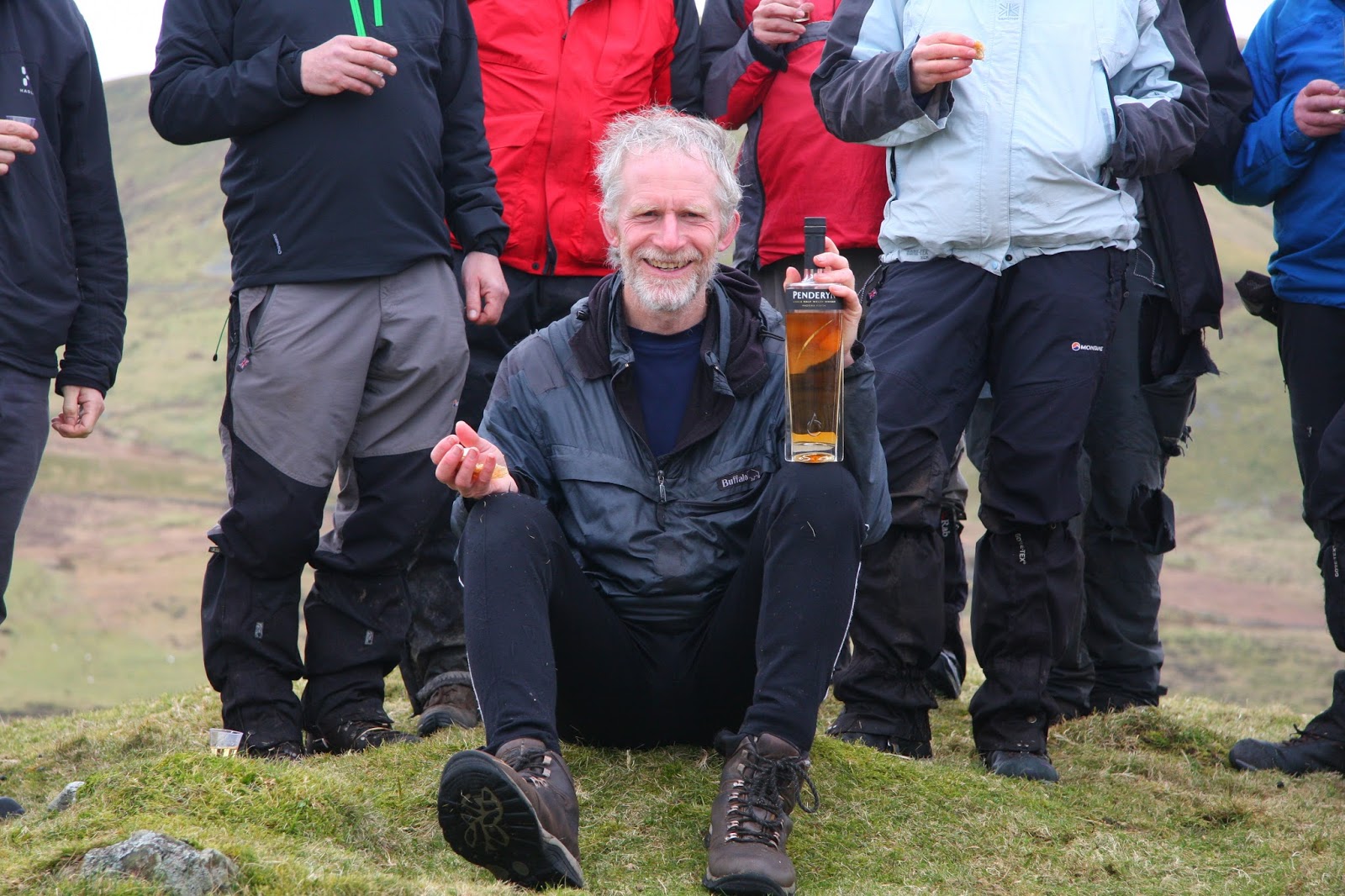
Rob was greeted at the summit of Ffridd Las by 14 people with the customary arch of ceremonial walking poles leading toward the high point of the hill; this was a fitting end to an unprecedented achievement.  We stood and sat beside the summit sampling a variety of cake toasting Rob’s latest amongst many incredible achievements.

At the summit of Ffridd Las

Rob completes the Welsh mainland Tumps on the summit of Ffridd Las

Visiting the Welsh P30s is something that I have enjoyed for many years, their variety seems to have no bounds, and they have brought me so many enjoyable experiences, with each one however small in height or grand in stature bringing its own unique charm and ambiance.  To have visited them all on the mainland must be such a fulfilling experience and my congratulations go out to Rob for being the first person to have done so.    
 
   
Survey Result:


Pared y Cefn Hir

Summit Height:  383.1m (converted to OSGM15, from previous Leica GS15 survey) (Sub-Trichant reclassified to Trichant)

Summit Grid Reference:  SH 66199 14885 (from previous Leica GS15 survey)

Bwlch Height:  233.7m (converted to OSGM15, Trimble GeoXH 6000)  233.7m (converted to OSGM15, Leica GS15)

Bwlch Grid Reference:  SH 65822 14423 (Trimble GeoXH 6000 and previous Leica GS15 survey)

Drop:  149.4m (from previous Leica GS15 survey)

Dominance:  39.00% (from previous Leica GS15 survey)


Thursday, 29 March 2018

Mapping Mountains – Significant Name Changes – 200m Twmpau


Ffridd Las (SH 660 139)

There has been a Significant Name Change to a hill that is listed in the 200m Twmpau, with the summit height, drop and status of the hill being confirmed by a Trimble GeoXH 6000 survey which took place on the 17th February 2018.

The criteria for the list that this name change applies to are:

200m Twmpau – All Welsh hills at and above 200m and below 300m in height that have 30m minimum drop, with the word Twmpau being an acronym standing for thirty welsh metre prominences and upward.  With an accompanying sub category entitled the 200m Sub-Twmpau consisting of all Welsh hills at and above 200m and below 300m in height that have 20m or more and below 30m of drop.

The hill is adjoined to the Cadair Idris range of hills which are situated in the south-western part of North Wales (Region A, Sub-Region A3), and it overlooks the double lakes of Llynnau Cregennan which are to its north and north north-east respectively and the small community of Arthog towards its west north-west. 

Ffridd Las (SH 660 139)

The hill appeared in the 200m P30 list on Geoff Crowder’s v-g.me website under the invented name of Bryn y Arthog with an accompanying note stating; Name from stream to the South.  During my early hill listing I thought it appropriate to either invent a name for a hill, or use a name that appeared near to the summit of the hill on Ordnance Survey maps of the day.  My preference was to use farm names and put Pen, Bryn or Moel in front of them, or as in this instance, use the name of a stream.  This is not a practice that I now advocate as with time and inclination place-name data can be improved either by asking local people or by examining historical documents, through this form of research an appropriate name for the hill can usually be found, and in the case of this hill it was the local farmer who grazes sheep on the land that the summit of the hill is situated on who gave the name of Ffridd Las.


Bryn y Arthog
    279m
    SH661140
    124
23
    Name from stream to the South


The local farmer is Arwyn Lloyd who farms from Ffridd Boedel which is situated directly below the hill to its north-west.  Whilst visiting this hill I called at this small farm house and met Arwyn, who is a Welsh speaker and has lived at Ffridd Boedel for 40 years.  We spent the next 30 minutes talking about the hills and their names, the ffriddoedd to the south-west of his farm, his life as a farmer and the name of the hill directly above his farm, Arwyn said that the hill is named Ffridd Las and it is a part of land that his sheep graze.

Arwyn Lloyd

Therefore, the name this hill is now listed by in the 200m Twmpau is Ffridd Las and this name was derived from local enquiry.


The full details for the hill are:

Group:  Cadair Idris

Name:  Ffridd Las

Previously Listed Name:  Bryn y Arthog 

Summit Height:  278.5m (converted to OSGM15)

OS 1:50,000 map:  124

Summit Grid Reference:  SH 66076 13984 
 
Drop:  30.7m (converted to OSGM15)


The Trimble GeoXH 6000 gathering data at the summit of Ffridd Las


Myrddyn Phillips (March 2018)


Tuesday, 27 March 2018

Mapping Mountains – Significant Name Changes – 200m Twmpau


Ffridd Tyddyn Mawr (SH 654 140)

There has been a Significant Name Change to a hill that is now listed in the 200m Twmpau, with the summit height, drop and status of the hill being confirmed by a Trimble GeoXH 6000 survey which was conducted by Myrddyn Phillips and took place on the 17th February 2018, and LIDAR analysis for the bwlch.

The criteria for the list that this name change applies to are:

200m Twmpau – All Welsh hills at and above 200m and below 300m in height that have 30m minimum drop, with the word Twmpau being an acronym for ‘thirty welsh metre prominences and upward’.  With an accompanying sub category entitled the 200m Sub-Twmpau consisting of all Welsh hills at and above 200m and below 300m in height that have 20m or more and below 30m of drop.

The hill is adjoined to the Cadair Idris range of hills which are situated in the south-western part of North Wales (Region A, Sub-Region A3), and it overlooks the double lakes of Llynnau Cregennan to its north north-east and the small community of Arthog towards its west north-west. 

Ffridd Tyddyn Mawr (SH 654 140) on the right of photo

The hill did not appear in the 200m P30 list on Geoff Crowder’s v-g.me website as it did not meet the criteria set for the accompanying sub list which was entitled Hills to be surveyed, however when this sub list was standardised and drop values later added the hill was listed with 20m of drop.

As the summit of this hill and that of its slightly lower south-easterly top positioned at SH 65693 13963 comprise bounded land the details for each were examined on the Tithe map.

The term Tithe map is generally given to a map of a Welsh or English parish or township and which was prepared after the 1836 Tithe Commutation Act.  This act allowed tithes to be paid in cash rather than goods.  The Tithe maps gave names of owners and occupiers of land in each parish and importantly for place-name research they also included the name of enclosed land.  This enclosed land is usually based on a field system, however not every field is given a name, but many are and especially so in Wales.

Extract from the Ordnance Survey 1:25,000 Explorer map

Extract from the Tithe map

The enclosed land where the summit of this hill is situated is given the number 103 on the Tithe map, this can be cross referenced against the apportionments; it is these apportionments that give the name of the owner or occupier of the land as well as the name of the land.  The land where the summit of this hill is situated is named as Tyddynmawr, the details on the Tithe map appear in the county named as Merioneth and in the parish of Llangelynin.

Extract from the apportionments

However, for confirmation of the land boundary I visited Arwyn Lloyd who lives and has farmed from Ffridd Boedel (SH 659 140) for 40 years, this small farm house is situated to the immediate east of this bounded land.  Arwyn described the whole of this bounded land as Ffriddoedd and confirmed that the summit of the hill which is positioned at SH 65486 14081 and which we were looking up to from just above his farm house is on land associated with Tyddyn Mawr, a farm positioned at SH 652 144, and that the name Ffridd Tyddyn Mawr is appropriate.

Arwyn Lloyd of Ffridd Boedel farm

Therefore, the name this hill is now listed by in the 200m Twmpau is Ffridd Tyddyn Mawr, and this was derived from the Tithe map and local enquiry.
 

The full details for the hill are:

Group:  Cadair Idris

Name:  Ffridd Tyddyn Mawr

Previously Listed Name:  not previously listed 

Summit Height:  273.2m (converted to OSGM15)

OS 1:50,000 map:  124

Summit Grid Reference:  SH 65486 14081 
 
Drop:  22.0m (Trimble summit and LIDAR bwlch)


The Trimble GeoXH 6000 gathering data at the summit of Ffridd Tyddyn Mawr (SH 654 140)


Myrddyn Phillips (March 2018)


Monday, 26 March 2018

Mapping Mountains – Significant Name Changes – 200m Twmpau


Ffridd Tyddyn Bach (SH 656 139)

There has been a Significant Name Change to a hill that was surveyed for 200m Sub-Twmpau status with the Trimble GeoXH 6000, with the summit height confirmed by the survey which was conducted by Myrddyn Phillips on the 17th February 2018, and LIDAR analysis for the bwlch.

The criteria for the list that this name change applies to are:

200m Twmpau – All Welsh hills at and above 200m and below 300m in height that have 30m minimum drop, with the word Twmpau being an acronym for ‘thirty welsh metre prominences and upward’.  With an accompanying sub category entitled the 200m Sub-Twmpau consisting of all Welsh hills at and above 200m and below 300m in height that have 20m or more and below 30m of drop.

The hill is adjoined to the Cadair Idris range of hills which are situated in the south-western part of North Wales (Region A, Sub-Region A3), and it overlooks the double lakes of Llynnau Cregennan to its north-east and the small community of Arthog towards its west north-west. 

Ffridd Tyddyn Bach (SH 656 139) on the left of photo

The hill did not appear in the 200m P30 list on Geoff Crowder’s v-g.me website as it did not meet the criteria set for the accompanying sub list which was entitled Hills to be surveyed, therefore it has not been included in any known hill list, however the name associated with it is worth documenting as it does not appear on any Ordnance Survey map.

As the summit of this hill and that of its slightly higher north-westerly top positioned at SH 65486 14081 comprise bounded land the details for each were examined on the Tithe map.

The term Tithe map is generally given to a map of a Welsh or English parish or township and which was prepared after the 1836 Tithe Commutation Act.  This act allowed tithes to be paid in cash rather than goods.  The Tithe maps gave names of owners and occupiers of land in each parish and importantly for place-name research they also included the name of enclosed land.  This enclosed land is usually based on a field system, however not every field is given a name, but many are and especially so in Wales.

Extract from the Ordnance Survey 1:25,000 Explorer map

Extract from the Tithe map

The enclosed land where the summit of this hill is situated is given the number 100b on the Tithe map, this can be cross referenced against the apportionments; it is these apportionments that give the name of the owner or occupier of the land as well as the name of the land.  The land where the summit of this hill is situated is named as Tyddynbach, the details on the Tithe map appear in the county named as Merioneth and in the parish of Llangelynin.

Extract from the apportionments

However, for confirmation of the land boundary I visited Arwyn Lloyd who lives and has farmed from Ffridd Boedel (SH 659 140) for 40 years, this small farm house is situated to the immediate east of this bounded land.  Arwyn described the whole of this bounded land as Ffriddoedd and confirmed that the summit of the hill which is positioned at SH 65693 13963 and which we were looking up to from just above his farm house is on land associated with Tyddyn Bach, a farm positioned at SH 654 145, and that the name Ffridd Tyddyn Bach is appropriate.

Arwyn Lloyd of Ffridd Boedel farm

Therefore, the name this hill is now documented by in relation to the 200m Twmpau is Ffridd Tyddyn Bach, and this was derived from the Tithe map and local enquiry.
 

The full details for the hill are:

Group:  Cadair Idris

Name:  Ffridd Tyddyn Bach

Previously Listed Name:  not previously listed 

Summit Height:  272.0m (converted to OSGM15)

OS 1:50,000 map:  124

Summit Grid Reference:  SH 65693 13963 
 
Drop:  12.4m (Trimble summit and LIDAR bwlch) 

The Trimble GeoXH 6000 gathering data at the summit of Ffridd Tyddyn Bach (SH 656 139)


Myrddyn Phillips (March 2018)