Mapping Mountains - Significant Name Changes - Y Trichant - The 300m Hills of Wales
Graig Fawr (SJ 096 226) - 175th significant name change
There has been a Significant Name Change to a hill that is listed in the Y Trichant – The 300m Hills of Wales, with the summit height, bwlch height and their locations, the drop and status of the hill derived from detail on contemporary maps produced from Ordnance Survey data.
The criteria for the list that this name change applies to are:
Y Trichant – The 300m Hills of Wales – Welsh hills at or above 300m and below 400m in height that have 30m minimum drop, with an accompanying sub list entitled the Sub-Trichant, with the criteria for this sub category being all Welsh hills at or above 300m and below 400m in height with 20m or more and below 30m of drop. The list is authored by Myrddyn Phillips with the Introduction to the list and the renaming of it appearing on Mapping Mountains on the 13th May 2017, and the Introduction to the Mapping Mountains publication of the list appearing on the 1st January 2022.
 |
| Y Trichant - The 300m Hills of Wales by Myrddyn Phillips |
The hill is adjoined to the Foel Cedig group of hills, which are situated in the southern part of North Wales (Region A, Sub-Region A3), and it is positioned with minor roads to its north, west and south, and the B4391 road to its east, and has the town of Llanfyllin towards the south-east.
During my early hill listing I thought it appropriate to either invent a name for a hill, or use a name that appeared near to the summit of the hill on Ordnance Survey maps of the day. My preference was to use farm names and put Pen, Bryn or Moel in front of them or as in this instance transpose a prominent name that appears on contemporary Ordnance Survey maps and presume it that of the hill. This is not a practice that I now advocate as with time and inclination place-name data can be improved either by asking local people or by examining historic documents, through this form of research an appropriate name for the hill can usually be found.
%20IMG_0685A%20-%201%2025000.jpg) |
| Extract from the Ordnance Survey 1:25,000 Explorer map |
As the summit of this hill comprises bounded land the details for it were examined on the Tithe map. The term Tithe map is generally given to a map of a Welsh or English parish or township and which was prepared after the 1836 Tithe Commutation Act. This act allowed tithes to be paid in cash rather than goods. The Tithe maps gave names of owners and occupiers of land in each parish and importantly for place-name research they also included the name of enclosed land. This enclosed land is usually based on a field system, however not every field is given a name, but many are and especially so in Wales.
%20IMG_0689A%20-%20Tithe.jpg) |
| Extract from the Tithe map |
The enclosed land where the summit of this hill is situated is given the number 791 on the Tithe map, this can be cross referenced against the apportionments; it is these apportionments that give the name of the owner or occupier of the land as well as the name of the land. The land where the summit of this hill is situated is named as Graig Fawr in the apportionments, with the details on the Tithe map appearing in the parish of Pennant and in the county named as Montgomery.
 |
| Extract from the apportionments |
Therefore, the name this hill is now listed by in the Y Trichant – The 300m Hills of Wales is Graig Fawr and this was derived from the Tithe map.
The full details for the hill are:
Group: Foel Cedig
Name: Graig Fawr
Previously Listed Name: Cefn Lle-oer
OS 1:50,000 map: 125
Summit Height: 334m (spot height)
Summit Grid Reference: SJ 09677 22687 (hand-held GPS via DoBIH)
Bwlch Height: 293m (spot height)
Bwlch Grid Reference: SJ 10414 22998 (spot height)
Drop: 41m (spot height summit and bwlch)
Myrddyn Phillips (July 2022)
Mapping Mountains - Significant Name Changes - Y Trichant - The 300m Hills of Wales
Top y Mynydd (SJ 159 213) - 174th significant name change
There has been a Significant Name Change to a hill that is listed in the Y Trichant – The 300m Hills of Wales, with the summit height, bwlch height and their locations, the drop and status of the hill derived from detail on contemporary maps produced from Ordnance Survey data.
The criteria for the list that this name change applies to are:
Y Trichant – The 300m Hills of Wales – Welsh hills at or above 300m and below 400m in height that have 30m minimum drop, with an accompanying sub list entitled the Sub-Trichant, with the criteria for this sub category being all Welsh hills at or above 300m and below 400m in height with 20m or more and below 30m of drop. The list is authored by Myrddyn Phillips with the Introduction to the list and the renaming of it appearing on Mapping Mountains on the 13th May 2017, and the Introduction to the Mapping Mountains publication of the list appearing on the 1st January 2022.
 |
| Y Trichant - The 300m Hills of Wales by Myrddyn Phillips |
The hill is adjoined to the Foel Cedig group of hills, which are situated in the southern part of North Wales (Region A, Sub-Region A3), and it is positioned encircled by minor roads, with the B4396 road farther to its north, the B4580 road farther to its west, the A490 road farther to its south and the B4393 road farther to its south-east, and has the town of Llanfyllin towards the south-west.
| Llechwedd-ddu West Top | 325m | SJ159213 | 125 | 239 | Name from hill to the East |
During my early hill listing I thought it appropriate to either invent a name for a hill, or use a name that appeared near to the summit of the hill on Ordnance Survey maps of the day. My preference was to use farm names and put Pen, Bryn or Moel in front of them or as in this instance use a directional name based on supplanting the name of a near hill and adding a directional component to it. This is not a practice that I now advocate as with time and inclination place-name data can be improved either by asking local people or by examining historic documents, through this form of research an appropriate name for the hill can usually be found.
%20IMG_0589A%20-%201%2025000.jpg) |
| Extract from the Ordnance Survey 1:25,000 Explorer map |
As the summit of this hill comprises bounded land the details for it were examined on the Tithe map. The term Tithe map is generally given to a map of a Welsh or English parish or township and which was prepared after the 1836 Tithe Commutation Act. This act allowed tithes to be paid in cash rather than goods. The Tithe maps gave names of owners and occupiers of land in each parish and importantly for place-name research they also included the name of enclosed land. This enclosed land is usually based on a field system, however not every field is given a name, but many are and especially so in Wales.
%20IMG_0595A%20-%20Tithe.jpg) |
| Extract from the Tithe map |
The enclosed land where the summit of this hill is situated is given the number 3 on the Tithe map, this can be cross referenced against the apportionments; it is these apportionments that give the name of the owner or occupier of the land as well as the name of the land. The land where the summit of this hill is situated is named as Top y Mynydd in the apportionments, with the details on the Tithe map appearing in the parish of Llanfechain and in the county named as Montgomery.
 |
| Extract from the apportionments |
Therefore, the name this hill is now listed by in the Y Trichant – The 300m Hills of Wales is Top y Mynydd and this was derived from the Tithe map.
The full details for the hill are:
Group: Foel Cedig
Name: Top y Mynydd
Previously Listed Name: Llechwedd-ddu West Top
OS 1:50,000 map: 125
Summit Height: 325m (spot height)
Summit Grid Reference: SJ 15984 21350 (hand-held GPS via DoBIH)
Bwlch Height: c 289m (interpolation)
Bwlch Grid Reference: SJ 16370 21339 (interpolation)
Drop: c 36m (spot height summit and interpolated bwlch)
Myrddyn Phillips (July 2022)
Mapping Mountains - Significant Name Changes - Y Trichant - The 300m Hills of Wales
Ffridd (SJ 164 212) - 173rd significant name change
There has been a Significant Name Change to a hill that is listed in the Y Trichant – The 300m Hills of Wales, with the summit height, bwlch height and their locations, the drop and status of the hill derived from detail on contemporary maps produced from Ordnance Survey data.
The criteria for the list that this name change applies to are:
Y Trichant – The 300m Hills of Wales – Welsh hills at or above 300m and below 400m in height that have 30m minimum drop, with an accompanying sub list entitled the Sub-Trichant, with the criteria for this sub category being all Welsh hills at or above 300m and below 400m in height with 20m or more and below 30m of drop. The list is authored by Myrddyn Phillips with the Introduction to the list and the renaming of it appearing on Mapping Mountains on the 13th May 2017, and the Introduction to the Mapping Mountains publication of the list appearing on the 1st January 2022.
 |
| Y Trichant - The 300m Hills of Wales by Myrddyn Phillips |
The hill is adjoined to the Foel Cedig group of hills, which are situated in the southern part of North Wales (Region A, Sub-Region A3), and it is positioned encircled by minor roads, with the B4396 road farther to its north, the B4580 road farther to its west, the A490 road farther to its south and the B4393 road farther to its south-east, and has the town of Llanfyllin towards the south-west.
During my early hill listing I thought it appropriate to either invent a name for a hill, or use a name that appeared near to the summit of the hill on Ordnance Survey maps of the day. My preference was to use farm names and put Pen, Bryn or Moel in front of them or as in this instance transpose the name of a farm and use it for that of the hill. This is not a practice that I now advocate as with time and inclination place-name data can be improved either by asking local people or by examining historic documents, through this form of research an appropriate name for the hill can usually be found.
%20IMG_0574A%20-%201%2025000.jpg) |
| Extract from the Ordnance Survey 1:25,000 Explorer map |
As the summit of this hill comprises bounded land the details for it were examined on the Tithe map. The term Tithe map is generally given to a map of a Welsh or English parish or township and which was prepared after the 1836 Tithe Commutation Act. This act allowed tithes to be paid in cash rather than goods. The Tithe maps gave names of owners and occupiers of land in each parish and importantly for place-name research they also included the name of enclosed land. This enclosed land is usually based on a field system, however not every field is given a name, but many are and especially so in Wales.
%20IMG_0576A%20-%20Tithe.jpg) |
| Extract from the Tithe map |
The enclosed land where the summit of this hill is situated is given the number 57 on the Tithe map, this can be cross referenced against the apportionments; it is these apportionments that give the name of the owner or occupier of the land as well as the name of the land. The land where the summit of this hill is situated is named as Ffridd in the apportionments, with the details on the Tithe map appearing in the parish of Llanfechain and in the county named as Montgomery.
%20IMG_0584A%20-%20apportionments.jpg) |
| Extract from the apportionments |
Therefore, the name this hill is now listed by in the Y Trichant – The 300m Hills of Wales is Ffridd and this was derived from the Tithe map.
The full details for the hill are:
Group: Foel Cedig
Name: Ffridd
Previously Listed Name: Llechwedd-ddu
OS 1:50,000 map: 125
Summit Height: 329m (spot height)
Summit Grid Reference: SJ 16492 21249 (hand-held GPS via DoBIH)
Bwlch Height: 276m (spot height)
Bwlch Grid Reference: SJ 15842 21559 (spot height)
Drop: 53m (spot height summit and bwlch)
Myrddyn Phillips (June 2022)
Mapping Mountains - Significant Name Changes - Y Trichant - The 300m Hills of Wales
Bryniau Gwenllian (SJ 001 139) - 172nd significant name change
Hill Reclassifications post for Bryniau Gwenllian
Significant Height Revisions post for Bryniau Gwenllian
There has been a Significant Name Change to a hill that is listed in the Y Trichant – The 300m Hills of Wales, with the summit height, bwlch height and their locations, the drop and status of the hill derived from detail on contemporary maps produced from Ordnance Survey data.
The criteria for the list that this name change applies to are:
Y Trichant – The 300m Hills of Wales – Welsh hills at or above 300m and below 400m in height that have 30m minimum drop, with an accompanying sub list entitled the Sub-Trichant, with the criteria for this sub category being all Welsh hills at or above 300m and below 400m in height with 20m or more and below 30m of drop. The list is authored by Myrddyn Phillips with the Introduction to the list and the renaming of it appearing on Mapping Mountains on the 13th May 2017, and the Introduction to the Mapping Mountains publication of the list appearing on the 1st January 2022.
 |
| Y Trichant - The 300m Hills of Wales by Myrddyn Phillips |
The hill is adjoined to the Esgeiriau Gwynion group of hills, which are situated in the southern part of North Wales (Region A, Sub-Region A3), and it is positioned with a minor road to its south-west, the A458 road farther to its south-west and the B4395 road to its east, and has the village of Llangadfan towards the south south-east.
After the sub list was standardised, and interpolated heights and drop values also included the details for this hill were re-evaluated and it was listed under the point (Pt. c 355m) notation with an estimated c 20m of drop, based on an estimated c 355m summit height and an estimated c 335m bwlch height, with both heights based on interpolation of 10m contouring that appear on the Ordnance Survey 1:25,000 Explorer map.
 |
| Extract from the Ordnance Survey 1:25,000 Explorer map |
As the summit of this hill comprises bounded land the details for it were examined on the Tithe map. The term Tithe map is generally given to a map of a Welsh or English parish or township and which was prepared after the 1836 Tithe Commutation Act. This act allowed tithes to be paid in cash rather than goods. The Tithe maps gave names of owners and occupiers of land in each parish and importantly for place-name research they also included the name of enclosed land. This enclosed land is usually based on a field system, however not every field is given a name, but many are and especially so in Wales, and importantly for this hill and its listed name, it is this map that names the land taking in the summit of this hill as Bryniau Gwen Llwyn.
 |
| Extract from the Tithe map |
Therefore, the name this hill is now listed by in the Y Trichant – The 300m Hills of Wales is Bryniau Gwenllian and this was derived from the Tithe map.
The full details for the hill are:
Group: Esgeiriau Gwynion
Name: Bryniau Gwenllian
Previously Listed Name: Pt. c 355m
OS 1:50,000 map: 125
Summit Height: 358m (spot height)
Summit Grid Reference: SJ 00115 13999 (spot height)
Bwlch Height: c 336m (interpolation)
Bwlch Grid Reference: SJ 00435 14248 (interpolation)
Drop: c 22m (spot height summit and interpolated bwlch)
Myrddyn Phillips (June 2022)
Mapping Mountains - Significant Name Changes - Y Trichant - The 300m Hills of Wales
Waun Llwyd (SJ 003 165) - 171st significant name change
Hill Reclassifications post for Waun Llwyd
Significant Height Revisions post for Waun Llwyd
There has been a Significant Name Change to a hill that is listed in the Y Trichant – The 300m Hills of Wales, with the summit height, bwlch height and their locations, the drop and status of the hill derived from LIDAR analysis conducted by Myrddyn Phillips.
%20-%20LIDAR%20summit%201.jpg) |
| LIDAR image of Waun Llwyd (SJ 003 165) |
The criteria for the list that this name change applies to are:
 |
| Y Trichant - The 300m Hills of Wales by Myrddyn Phillips |
The hill is adjoined to the Esgeiriau Gwynion group of hills, which are situated in the southern part of North Wales (Region A, Sub-Region A3), and it is positioned with a minor road to its north and east, and has the village of Llanwddyn towards the north-east.
After the sub list was standardised, and interpolated heights and drop values also included the details for this hill were re-evaluated and it was listed as Moel Achles, which is a prominent name that appears close to the summit of this hill on the contemporary Ordnance Survey 1:50,000 Landranger and 1:25,000 Explorer map.
%20IMG_0817A%20-%201%2025000.jpg) |
| Extract from the Ordnance Survey 1:25,000 Explorer map |
During my early hill listing I paid little regard to name placement on the map, or the meaning of names and to what feature the name was appropriately applied to. Therefore, I prioritised names for listing purposes that I now understand are either inappropriate or where another name is viewed as being more appropriate.
This is not a practice that I now advocate as with time and inclination place-name data can be improved either by asking local people or by examining historic documents, through this form of research an appropriate name for the hill can usually be found.
As the summit of this hill comprises bounded land the details for it were examined on the Tithe map. The term Tithe map is generally given to a map of a Welsh or English parish or township and which was prepared after the 1836 Tithe Commutation Act. This act allowed tithes to be paid in cash rather than goods. The Tithe maps gave names of owners and occupiers of land in each parish and importantly for place-name research they also included the name of enclosed land. This enclosed land is usually based on a field system, however not every field is given a name, but many are and especially so in Wales.
%20IMG_0821A%20-%20Tithe.jpg) |
| Extract from the Tithe map |
The enclosed land where the summit of this hill is situated is given the number 91 on the Tithe map, this can be cross referenced against the apportionments; it is these apportionments that give the name of the owner or occupier of the land as well as the name of the land. The land where the summit of this hill is situated is named as Waun Llwyd in the apportionments, with the details on the Tithe map appearing in the parish of Llangadfan and in the county named as Montgomery.
%20IMG_0832A%20-%20apportionments.jpg) |
| Extract from the apportionments |
Therefore, the name this hill is now listed by in the Y Trichant – The 300m Hills of Wales is Waun Llwyd and this was derived from the Tithe map.
The full details for the hill are:
Group: Esgeiriau Gwynion
Name: Waun Llwyd
Previously Listed Name: Moel Achles
OS 1:50,000 map: 125
Summit Height: 367.4m (LIDAR)
Summit Grid Reference: SJ 00323 16521 (LIDAR)
Bwlch Height: 345.2m (LIDAR)
Bwlch Grid Reference: SJ 00193 16719 (LIDAR)
Drop: 22.2m (LIDAR)
Myrddyn Phillips (June 2022)
Mapping Mountains - Significant Name Changes - Y Trichant - The 300m Hills of Wales
Crug Melyn (SN 502 285) - 170th significant name change
There has been a Significant Name Change to a hill that is listed in the Y Trichant – The 300m Hills of Wales and Y Trechol – The Dominant Hills of Wales, with the summit height, bwlch height and their locations, the drop, dominance and status of the hill derived from detail on contemporary maps produced from Ordnance Survey data.
The criteria for the two listings that this name change applies to are:
Y Trichant – The 300m Hills of Wales – Welsh hills at or above 300m and below 400m in height that have 30m minimum drop, with an accompanying sub list entitled the Sub-Trichant, with the criteria for this sub category being all Welsh hills at or above 300m and below 400m in height with 20m or more and below 30m of drop. The list is authored by Myrddyn Phillips with the Introduction to the list and the renaming of it appearing on Mapping Mountains on the 13th May 2017, and the Introduction to the Mapping Mountains publication of the list appearing on the 1st January 2022.
 |
| Y Trichant - The 300m Hills of Wales by Myrddyn Phillips |
.jpg) |
| Y Trechol - The Dominant Hills of Wales by Myrddyn Phillips |
The hill is adjoined to the Mynydd Pencarreg group of hills, which are situated in the south-western part of South Wales (Region B, Sub-Region B1), and it is positioned with a minor road to its north and south-west and the B4310 road to its east, and has the small community of Brechfa towards the north-east.
| Pen-crug-melyn | 326m | SN503285 | 146 | 186 | Marilyn. Clem/Yeaman. Trig pillar. |
During my early hill listing I paid little regard to name placement on the map, or the meaning of names and to what feature the name was appropriately applied to. Therefore, I prioritised names for listing purposes that I now understand are either inappropriate or where another name is viewed as being more appropriate.
This is not a practice that I now advocate as with time and inclination place-name data can be improved either by asking local people or by examining historic documents, through this form of research an appropriate name for the hill can usually be found.
%20IMG_0419A%20-%201%2025000.jpg) |
| Extract from the Ordnance Survey 1:25,000 Explorer map |
Since the original publication of the Welsh P30 lists on Geoff Crowder’s v-g.me website there have been a number of maps made available online. Some of these are historic such as the series of Six-Inch maps on the National Library of Scotland website. Whilst others were digitally updated such as the Ordnance Survey Vector Map Local that was hosted on the Geograph website and which was entitled the Interactive Coverage Map, whilst others are current and digitally updated such as the interactive mapping on the Magic Maps and WalkLakes websites, and it is the series of Six-Inch maps that were consulted for name placement in relation to this hill.
%20IMG_0423A%20-%20Six-Inch.jpg) |
| Extract from the Ordnance Surveys series of Six-Inch maps |
The Ordnance Survey series of Six-Inch maps formed the base map Ordnance Survey used for many decades leading to the production of the 1:10,000 Series of maps, both have now been superseded by the digitised Master Map. The series of Six-Inch maps are excellent for name placement and especially so compared to the contemporary Ordnance Survey 1:25,000 Explorer map, and it is the series of Six-Inch maps that give the name of Crug Melyn in relation to this hill with that of Pen-crug-melyn placed adjacent to a farm which is positioned just under the summit of this hill.
Therefore, the name this hill is now listed by in the Y Trichant – The 300m Hills of Wales and Y Trechol – The Dominant Hills of Wales is Crug Melyn and this was derived from the contemporary Ordnance Survey 1:25,000 Explorer map with its placement substantiated from the Ordnance Survey series of Six-Inch maps.
The full details for the hill are:
Group: Mynydd Pencarreg
Name: Crug Melyn
Previously Listed Name: Pen-crug-melyn
OS 1:50,000 map: 146
Summit Height: 326m (spot height)
Summit Grid Reference: SN 50274 28508 (hand-held GPS via DoBIH)
Bwlch Height: c 142m (interpolation)
Bwlch Grid Reference: SN 48763 29385 (interpolation)
Drop: c 184m (spot height summit and interpolated bwlch)
Dominance: 56.44% (spot height summit and interpolated bwlch)
Myrddyn Phillips (June 2022)
Mapping Mountains - Significant Name Changes - Y Trichant - The 300m Hills of Wales
Lan Ddu Cilwenau (SN 572 371) - 169th significant name change
Summit Relocations post for Lan Ddu Cilwenau
Significant Height Revisions post for Lan Ddu Cilwenau
There has been a Significant Name Change to a hill that is listed in the Y Trichant – The 300m Hills of Wales and Y Trechol – The Dominant Hills of Wales, with the summit height, bwlch height and their locations, the drop, dominance and status of the hill derived from detail on contemporary maps produced from Ordnance Survey data and LIDAR analysis conducted by Myrddyn Phillips.
 |
| LIDAR image of Lan Ddu Cilwenau (SN 572 371) |
The criteria for the two listings that this name change applies to are:
 |
| Y Trichant - The 300m Hills of Wales by Myrddyn Phillips |
 |
| Y Trechol - The Dominant Hills of Wales by Myrddyn Phillips |
The hill is adjoined to the Mynydd Pencarreg group of hills, which are situated in the south-western part of South Wales (Region B, Sub-Region B1), and it is positioned with the B4337 road to its north-east, a minor road to its south-west and the B4310 road to its south-east, and has the village of Llansawel towards the east south-east.
| Lan Ddu Cilwenau West Top | 328m | SN576371 | 146 | 186 | Clem/Yeaman. Name from hill to the East. |
During my early hill listing I thought it appropriate to either invent a name for a hill, or use a name that appeared near to the summit of the hill on Ordnance Survey maps of the day. My preference was to use farm names and put Pen, Bryn or Moel in front of them or as in this instance use a directional name based on supplanting the name of a near hill and adding a directional component to it. This is not a practice that I now advocate as with time and inclination place-name data can be improved either by asking local people or by examining historic documents, through this form of research an appropriate name for the hill can usually be found.
 |
| Extract from the Ordnance Survey 1:25,000 Explorer map |
As the summit of this hill comprises bounded land the details for it were examined on the Tithe map. The term Tithe map is generally given to a map of a Welsh or English parish or township and which was prepared after the 1836 Tithe Commutation Act. This act allowed tithes to be paid in cash rather than goods. The Tithe maps gave names of owners and occupiers of land in each parish and importantly for place-name research they also included the name of enclosed land. This enclosed land is usually based on a field system, however not every field is given a name, but many are and especially so in Wales.
The website hosting the Welsh Tithe maps also hosts historical and contemporary Ordnance Survey and satellite maps and it is one of the historic Ordnance Survey One-Inch maps that positions the name of Lan Ddu Cilwenau taking in this land incorporating this hill.
 |
| Extract from a historical Ordnance Survey One-Inch map available on the website hosting the Welsh Tithe maps |
Therefore, the name this hill is now listed by in the Y Trichant – The 300m Hills of Wales and Y Trechol – The Dominant Hills of Wales is Lan Ddu Cilwenau and this was derived from a historic Ordnance Survey One-Inch map available on the website hosting the Welsh Tithe maps.
The full details for the hill are:
Group: Mynydd Pencarreg
Name: Lan Ddu Cilwenau
Previously Listed Name: Lan Ddu Cilwenau West Top
OS 1:50,000 map: 146
Summit Height: 333.1m (LIDAR)
Summit Grid Reference: SN 57277 37147 (LIDAR)
Bwlch Height: c 211m (interpolation)
Bwlch Grid Reference: SN 56467 37617 (interpolation)
Drop: c 122m (LIDAR summit and interpolated bwlch)
Dominance: 36.66% (LIDAR summit and interpolated bwlch)
Myrddyn Phillips (May 2022)
Mapping Mountains - Significant Name Changes - Y Trichant - The 300m Hills of Wales
Ffridd Cedig (SJ 006 150) - 168th significant name change
Hill Reclassifications post for Ffridd Cedig
There has been a Significant Name Change to a hill that is listed in the Y Trichant – The 300m Hills of Wales, with the summit height, bwlch height and their locations, the drop and status of the hill derived from LIDAR analysis conducted by Myrddyn Phillips.
%20-%20LIDAR%20hill%202.jpg) |
| LIDAR image of Ffridd Cedig (SJ 006 150) |
The criteria for the list that this name change applies to are:
 |
| Y Trichant - The 300m Hills of Wales by Myrddyn Phillips |
The hill is adjoined to the Esgeiriau Gwynion group of hills, which are situated in the southern part of North Wales (Region A, Sub-Region A3), and it is positioned with a minor road to its north, south-west and north-east, and the B4395 road to its south-east, and has the village of Llangadfan towards the south.
The hill appeared in the original Welsh 300m P30 list on Geoff Crowder’s v-g.me website, under the transposed name of Ffridd Cae-penfras, which is a prominent name that appears near the summit of this hill on the Ordnance Survey 1:50,000 Landranger and 1:25,000 Explorer map.
During my early hill listing I paid little regard to name placement on the map, or the meaning of names and to what feature the name was appropriately applied to. Therefore, I prioritised names for listing purposes that I now understand are either inappropriate or where another name is viewed as being more appropriate.
This is not a practice that I now advocate as with time and inclination place-name data can be improved either by asking local people or by examining historic documents, through this form of research an appropriate name for the hill can usually be found.
%20IMG_0767A%20-%201%2025000.jpg) |
| Extract from the Ordnance Survey 1:25,000 Explorer map |
As the summit of this hill comprises bounded land the details for it were examined on the Tithe map. The term Tithe map is generally given to a map of a Welsh or English parish or township and which was prepared after the 1836 Tithe Commutation Act. This act allowed tithes to be paid in cash rather than goods. The Tithe maps gave names of owners and occupiers of land in each parish and importantly for place-name research they also included the name of enclosed land. This enclosed land is usually based on a field system, however not every field is given a name, but many are and especially so in Wales.
%20IMG_0775A%20-%20Tithe.jpg) |
| Extract from the Tithe map |
The enclosed land where the summit of this hill is situated is given the number 302 on the Tithe map, this can be cross referenced against the apportionments; it is these apportionments that give the name of the owner or occupier of the land as well as the name of the land. The land where the summit of this hill is situated is named as Ffridd Cedig in the apportionments, with the details on the Tithe map appearing in the parish of Llangadfan and in the county named as Montgomery.
 |
| Extract from the apportionments |
Therefore, the name this hill is now listed by in the Y Trichant – The 300m Hills of Wales is Ffridd Cedig and this was derived from the Tithe map.
The full details for the hill are:
Group: Esgeiriau Gwynion
Name: Ffridd Cedig
Previously Listed Name: Ffridd Cae-penfras
OS 1:50,000 map: 125
Summit Height: 339.7m (LIDAR)
Summit Grid Reference: SJ 00605 15009 (LIDAR)
Bwlch Height: 309.8m (LIDAR)
Bwlch Grid Reference: SJ 00639 14751 (LIDAR)
Drop: 29.9m (LIDAR)
Myrddyn Phillips (May 2022)
Mapping Mountains - Significant Name Changes - Y Trichant - The 300m Hills of Wales
Ffridd Cae Penfras (SJ 007 146) - 167th significant name change
There has been a Significant Name Change to a hill that is listed in the Y Trichant – The 300m Hills of Wales, with the summit height, bwlch height and their locations, the drop and status of the hill derived from detail on contemporary maps produced from Ordnance Survey data.
%20-%20part%20LIDAR%20summit%202.jpg) |
| LIDAR part image of Ffridd Cae Penfras (SJ 007 146) |
The criteria for the list that this name change applies to are:
 |
| Y Trichant - The 300m Hills of Wales by Myrddyn Phillips |
The hill is adjoined to the Esgeiriau Gwynion group of hills, which are situated in the southern part of North Wales (Region A, Sub-Region A3), and it is positioned with a minor road to its north and south-west, the A458 road to its south and the B4395 road to its east, and has the village of Llangadfan towards the south.
The hill appeared in the original Welsh 300m P30 list on Geoff Crowder’s v-g.me website, under the transposed name of Pren Croes, which is a prominent name that appears to the south of the summit of this hill on the Ordnance Survey 1:50,000 Landranger and 1:25,000 Explorer map.
During my early hill listing I paid little regard to name placement on the map, or the meaning of names and to what feature the name was appropriately applied to. Therefore, I prioritised names for listing purposes that I now understand are either inappropriate or where another name is viewed as being more appropriate.
This is not a practice that I now advocate as with time and inclination place-name data can be improved either by asking local people or by examining historic documents, through this form of research an appropriate name for the hill can usually be found.
%20IMG_0752A%20-%201%2025000.jpg) |
| Extract from the Ordnance Survey 1:25,000 Explorer map |
As the summit of this hill comprises bounded land the details for it were examined on the Tithe map. The term Tithe map is generally given to a map of a Welsh or English parish or township and which was prepared after the 1836 Tithe Commutation Act. This act allowed tithes to be paid in cash rather than goods. The Tithe maps gave names of owners and occupiers of land in each parish and importantly for place-name research they also included the name of enclosed land. This enclosed land is usually based on a field system, however not every field is given a name, but many are and especially so in Wales.
%20IMG_0757A%20-%20Tithe.jpg) |
| Extract from the Tithe map |
The enclosed land where the summit of this hill is situated is given the number 303 on the Tithe map, this can be cross referenced against the apportionments; it is these apportionments that give the name of the owner or occupier of the land as well as the name of the land. The land where the summit of this hill is situated is named as Ffridd Cae Penfras in the apportionments, with the details on the Tithe map appearing in the parish of Llangadfan and in the county named as Montgomery.
 |
| Extract from the apportionments |
Therefore, the name this hill is now listed by in the Y Trichant – The 300m Hills of Wales is Ffridd Cae Penfras and this was derived from the Tithe map, which substantiates its use on the contemporary Ordnance Survey 1:50,000 Landranger and 1:25,000 Explorer map.
The full details for the hill are:
Group: Esgeiriau Gwynion
Name: Ffridd Cae Penfras
Previously Listed Name: Pren Croes
OS 1:50,000 map: 125
Summit Height: 368m (spot height)
Summit Grid Reference: SJ 00728 14605 (hand-held GPS via DoBIH)
Bwlch Height: c 318m (interpolation)
Bwlch Grid Reference: SJ 00178 14557 (interpolation)
Drop: c 50m (spot height summit and interpolated bwlch)
Myrddyn Phillips (May 2022)
Mapping Mountains - Significant Name Changes - Y Trichant - The 300m Hills of Wales
Banc Garreg Winau (SN 562 414) - 166th significant name change
There has been a Significant Name Change to a hill that is listed in the Y Trichant – The 300m Hills of Wales, with the summit height, bwlch height and their locations, the drop and status of the hill derived from detail on contemporary maps produced from Ordnance Survey data.
The criteria for the list that this name change applies to are:
Y Trichant – The 300m Hills of Wales – Welsh hills at or above 300m and below 400m in height that have 30m minimum drop, with an accompanying sub list entitled the Sub-Trichant, with the criteria for this sub category being all Welsh hills at or above 300m and below 400m in height with 20m or more and below 30m of drop. The list is authored by Myrddyn Phillips with the Introduction to the list and the renaming of it appearing on Mapping Mountains on the 13th May 2017, and the Introduction to the Mapping Mountains publication of the list appearing on the 1st January 2022.
 |
| Y Trichant - The 300m Hills of Wales by Myrddyn Phillips |
The hill is adjoined to the Mynydd Pencarreg group of hills, which are situated in the south-western part of South Wales (Region B, Sub-Region B1), and it is positioned with a minor road to its east and the B4337 road to its south-west, and has the town of Llanybydder towards the north-west.
%20IMG_0394A%20-%201%2025000.jpg) |
| Extract from the Ordnance Survey 1:25,000 Explorer map |
The hill appeared in the original Welsh 300m P30 list on Geoff Crowder’s v-g.me website, under the transposed name of Llwyndrissi, with an accompanying note stating; aka Banc Garregwinau. With the prioritised name appearing near the summit of this hill on the contemporary Ordnance Survey 1:50,000 Landranger and 1:25,000 Explorer map.
| Llwyndrissi | 369m | SN562414 | 146 | 186 | Included by contour configuration. aka Banc Garregwinau |
Since the original publication of the Welsh P30 lists on Geoff Crowder’s v-g.me website there have been a number of maps made available online. Some of these are historic such as the series of Six-Inch maps on the National Library of Scotland website. Whilst others were digitally updated such as the Ordnance Survey Vector Map Local that was hosted on the Geograph website and which was entitled the Interactive Coverage Map, whilst others are current and digitally updated such as the interactive mapping on the Magic Maps and WalkLakes websites, and it is the Ordnance Survey series of Six-Inch maps that give the name of Banc Garreg Winau near the summit of this hill complimenting its position on the Ordnance Survey 1:25,000 Explorer map.
%20IMG_0400A%20-%20Six-Inch.jpg) |
| Extract from the Ordnance Survey series of Six-Inch maps |
Therefore, the name this hill is now listed by in the Y Trichant – The 300m Hills of Wales is Banc Garreg Winau, and this was derived from the contemporary Ordnance Survey 1:25,000 Explorer map with the name placement substantiated by the Ordnance Survey series of Six-Inch maps.
The full details for the hill are:
Group: Mynydd Pencarreg
Name: Banc Garreg Winau
Previously Listed Name: Llwyndrissi
OS 1:50,000 map: 146
Summit Height: 369m (spot height)
Summit Grid Reference: SN 56242 41456 (hand-held GPS via DoBIH)
Bwlch Height: 338m (spot height)
Bwlch Grid Reference: SN 56765 41224 (spot height)
Drop: 31m (spot height summit and bwlch)
Myrddyn Phillips (May 2022)
Mapping Mountains - Significant Name Changes - Y Trichant - The 300m Hills of Wales
Foel Fain (SH 983 124) - 165th significant name change
There has been a Significant Name Change to a hill that is listed in the Y Trichant – The 300m Hills of Wales, with the summit height, bwlch height and their locations, the drop and status of the hill derived from LIDAR analysis conducted by Myrddyn Phillips.
%20-%20LIDAR%20hill%201.jpg) |
| LIDAR image of Foel Fain (SH 983 124) |
The criteria for the list that this name change applies to are:
 |
| Y Trichant - The 300m Hills of Wales by Myrddyn Phillips |
The hill is adjoined to the Esgeiriau Gwynion group of hills, which are situated in the southern part of North Wales (Region A, Sub-Region A3), and it is positioned with a minor road to its north and east and the A458 road to its south, and has the village of Llangadfan towards the south-east.
| Y Fron East Top | 320m | SH983124 | 125 | 239 | Name from hill to the West. |
During my early hill listing I thought it appropriate to either invent a name for a hill, or use a name that appeared near to the summit of the hill on Ordnance Survey maps of the day. My preference was to use farm names and put Pen, Bryn or Moel in front of them or as in this instance use a directional name based on supplanting the name of a near hill and adding a directional component to it. This is not a practice that I now advocate as with time and inclination place-name data can be improved either by asking local people or by examining historic documents, through this form of research an appropriate name for the hill can usually be found.
%20IMG_1063A%20-%201%2025000.jpg) |
| Extract from the Ordnance Survey 1:25,000 Explorer map |
Since the original publication of the Welsh P30 lists on Geoff Crowder’s v-g.me website there have been a number of maps made available online. Some of these are historic such as the series of Six-Inch maps on the National Library of Scotland website. Whilst others were digitally updated such as the Ordnance Survey Vector Map Local that was hosted on the Geograph website and which was entitled the Interactive Coverage Map, whilst others are current and digitally updated such as the interactive mapping on the Magic Maps and WalkLakes websites.
The details for this hill were re-assessed when the Ordnance Survey Vector Map Local hosted on the Geograph website and which was entitled the Interactive Coverage Map became available online. This mapping had the name of Foel Fain positioned close to the summit of this hill.
Another of the mapping resources now available online is the Magic Maps website which hosts an interactive map originated from Ordnance Survey data. This mapping also shows the name of Foel Fain positioned close to the summit of this hill.
%20IMG_1058A%20-%20Magic%20Maps.jpg) |
| Extract from the Magic Maps website |
Therefore, the name this hill is now listed by in the Y Trichant – The 300m Hills of Wales is Foel Fain and this was derived from Ordnance Survey Vector Map Local hosted on the Geograph website and which was entitled the Interactive Coverage Map.
The full details for the hill are:
Group: Esgeiriau Gwynion
Name: Foel Fain
Previously Listed Name: Y Fron East Top
OS 1:50,000 map: 125
Summit Height: 319.8m (LIDAR)
Summit Grid Reference: SH 98313 12471 (LIDAR)
Bwlch Height: 299.1m (LIDAR)
Bwlch Grid Reference: SH 98122 12507 & SH 98106 12503 (LIDAR)
Drop: 20.7m (LIDAR)
Myrddyn Phillips (May 2022)
Mapping Mountains - Significant Name Changes - Y Trichant - The 300m Hills of Wales
Waun Oer (SH 978 126) - 164th significant name change
There has been a Significant Name Change to a hill that is listed in the Y Trichant – The 300m Hills of Wales, with the summit height, bwlch height and their locations, the drop and status of the hill derived from detail on contemporary maps produced from Ordnance Survey data and LIDAR analysis conducted by Myrddyn Phillips.
%20-%20LIDAR%20summit%202.jpg) |
| LIDAR image of Waun Oer (SH 978 126) |
The criteria for the list that this name change applies to are:
 |
| Y Trichant - The 300m Hills of Wales by Myrddyn Phillips |
The hill is adjoined to the Esgeiriau Gwynion group of hills, which are situated in the southern part of North Wales (Region A, Sub-Region A3), and it is positioned with a minor road to its north and east and the A458 road to its south, and has the village of Llangadfan towards the south-east.
The hill appeared in the original Welsh 300m P30 list on Geoff Crowder’s v-g.me website, under the transposed name of Y Fron, which is a prominent name that appears to the south-east of the summit of this hill on the Ordnance Survey 1:50,000 Landranger and 1:25,000 Explorer map.
During my early hill listing I paid little regard to name placement on the map, or the meaning of names and to what feature the name was appropriately applied to. Therefore, I prioritised names for listing purposes that I now understand are either inappropriate or where another name is viewed as being more appropriate, with the previously listed name of Y Fron more applicable to land that does not take in the summit of this hill.
This is not a practice that I now advocate as with time and inclination place-name data can be improved either by asking local people or by examining historic documents, through this form of research an appropriate name for the hill can usually be found.
%20IMG_1032A%20-%201%2025000.jpg) |
| Extract from the Ordnance Survey 1:25,000 Explorer map |
As the summit of this hill comprises bounded land the details for it were examined on the Tithe map. The term Tithe map is generally given to a map of a Welsh or English parish or township and which was prepared after the 1836 Tithe Commutation Act. This act allowed tithes to be paid in cash rather than goods. The Tithe maps gave names of owners and occupiers of land in each parish and importantly for place-name research they also included the name of enclosed land. This enclosed land is usually based on a field system, however not every field is given a name, but many are and especially so in Wales.
%20IMG_1040A%20-%20Tithe.jpg) |
| Extract from the Tithe map |
The enclosed land where the summit of this hill is situated is given the number 250 on the Tithe map, this can be cross referenced against the apportionments; it is these apportionments that give the name of the owner or occupier of the land as well as the name of the land. The land where the summit of this hill is situated is named as Waun Oer in the apportionments, with the details on the Tithe map appearing in the parish of Garthbeibio and in the county named as Montgomery.
%20IMG_1046A%20-%20apportionments.jpg) |
| Extract from the apportionments |
Therefore, the name this hill is now listed by in the Y Trichant – The 300m Hills of Wales is Waun Oer and this was derived from the Tithe map.
The full details for the hill are:
Group: Esgeiriau Gwynion
Name: Waun Oer
Previously Listed Name: Y Fron
OS 1:50,000 map: 125
Summit Height: 321.7m (LIDAR)
Summit Grid Reference: SH 97861 12609 (LIDAR)
Bwlch Height: 294m (spot height)
Bwlch Grid Reference: SH 97046 13253 (spot height)
Drop: 28m (LIDAR summit and spot height bwlch)
Myrddyn Phillips (May 2022)
Mapping Mountains - Significant Name Changes - Y Trichant - The 300m Hills of Wales
Ffridd Eithin (SH 951 133) - 163rd significant name change
Hill Reclassifications post for Ffridd Eithin
There has been a Significant Name Change to a hill that is listed in the Y Trichant – The 300m Hills of Wales, with the summit height, bwlch height and their locations, the drop and status of the hill confirmed by LIDAR analysis conducted by Myrddyn Phillips.
%20-%20LIDAR%20hill%204.jpg) |
| LIDAR image of Ffridd Eithin (SH 951 133) |
The criteria for the list that this name change applies to are:
 |
| Y Trichant - The 300m Hills of Wales by Myrddyn Phillips |
The hill is adjoined to the Esgeiriau Gwynion group of hills, which are situated in the southern part of North Wales (Region A, Sub-Region A3), and it is positioned with a minor road to its north-east and the A458 road to its south-west, and has the village of Llangadfan towards the south-east.
After the sub list was standardised, and interpolated heights and drop values also included the details for this hill were re-assessed and it was listed under the point (Pt. 339m) notation with an estimated c 22m of drop, based on the 339m summit spot height that appears on the Ordnance Survey 1:50,000 Landranger and the 1:25,000 Explorer map and an estimated c 317m bwlch height, based on interpolation of 10m contouring between 310m – 320m.
%20IMG_1010A%20-%201%2025000.jpg) |
| Extract from the Ordnance Survey 1:25,000 Explorer map |
As the summit of this hill comprises bounded land the details for it were examined on the Tithe map. The term Tithe map is generally given to a map of a Welsh or English parish or township and which was prepared after the 1836 Tithe Commutation Act. This act allowed tithes to be paid in cash rather than goods. The Tithe maps gave names of owners and occupiers of land in each parish and importantly for place-name research they also included the name of enclosed land. This enclosed land is usually based on a field system, however not every field is given a name, but many are and especially so in Wales.
%20IMG_1016A%20-%20Tithe.jpg) |
| Extract from the Tithe map |
The enclosed land where the summit of this hill is situated is given the number 555 on the Tithe map, this can be cross referenced against the apportionments; it is these apportionments that give the name of the owner or occupier of the land as well as the name of the land. The land where the summit of this hill is situated is named as Ffridd Eithin in the apportionments, with the details on the Tithe map appearing in the parish of Garthbeibio and in the county named as Montgomery.
%20IMG_1025A%20-%20apportionments.jpg) |
| Extract from the apportionments |
Therefore, the name this hill is now listed by in the Y Trichant – The 300m Hills of Wales is Ffridd Eithin and this was derived from the Tithe map.
The full details for the hill are:
Group: Esgeiriau Gwynion
Name: Ffridd Eithin
Previously Listed Name: Pt. 339m
OS 1:50,000 map: 125
Summit Height: 339.0m (LIDAR)
Summit Grid Reference: SH 95181 13385 (LIDAR)
Bwlch Height: 317.5m (LIDAR)
Bwlch Grid Reference: SH 95059 13719 (LIDAR)
Drop: 21.5m (LIDAR)
Myrddyn Phillips (May 2022)
Mapping Mountains - Significant Name Changes - Y Trichant - The 300m Hills of Wales
Pen Rallt (SN 951 859) - 162nd significant name change
Survey post for Pen Rallt
There has been a Significant Name Change to a hill that is listed in the Y Trichant – The 300m Hills of Wales, with the summit height, bwlch height and their locations, the drop and status of the hill confirmed by a Trimble GeoXH 6000 survey and LIDAR analysis conducted by Myrddyn Phillips.
 |
| LIDAR image of Pen Rallt (SN 951 859) |
The criteria for the list that this name change applies to are:
 |
| Y Trichant - The 300m Hills of Wales by Myrddyn Phillips |
The hill is adjoined to the Pumlumon group of hills, which are situated in the north-western part of South Wales (Region B, Sub-Region B1), and it is positioned with a minor road to its north-west, the B4518 road to its south-west and the B4569 road to its east, and has the town of Llanidloes towards the south.
| Mynydd Penrallt | 301m | SN952859 | 136 | 214 | Name from buildings to the East |
During my early hill listing I thought it appropriate to either invent a name for a hill, or use a name that appeared near to the summit of the hill on Ordnance Survey maps of the day. My preference was to use farm names and put Pen, Bryn or Moel in front of them or as in this instance transpose the name of a farm and add the word Mynydd to it. This is not a practice that I now advocate as with time and inclination place-name data can be improved either by asking local people or by examining historic documents, through this form of research an appropriate name for the hill can usually be found.
 |
| Extract from the Ordnance Survey 1:25,000 Explorer map |
After visiting this hill I called at Penrallt; the farm just below the summit to its east. I knocked on the front door and was met by Janet Breeze, I explained my interest in the hill and its name, Janet explained that the section of land taking in the near golf course, the wood to the south of the summit, and the high grazing field that incorporates the summit of this hill is all known as Pen Rallt, with Janet telling me she is a Welsh speaker and advising the name spelt with two words.
 |
| Janet Breeze of Penrallt farm |
During our conversation Janet told me her husband; Graham was out lambing and that she had married in to the farm with the family having lived here since April 1970. I asked about the high field that incorporates the summit of this hill and she told me that its field name is the Top Meadow.
Therefore, the name this hill is now listed by in the Y Trichant – The 300m Hills of Wales is Pen Rallt, and this was derived from local enquiry.
The full details for the hill are:
Group: Pumlumon
Name: Pen Rallt
Previously Listed Name: Mynydd Penrallt
OS 1:50,000 map: 136
Summit Height: 301.9m (converted to OSGM15, Trimble GeoXH 6000)
Summit Grid Reference: SN 95168 85960 (Trimble GeoXH 6000)
Bwlch Height: 223.9m (LIDAR)
Bwlch Grid Reference: SN 94689 85959 (LIDAR)
Drop: 78.0m (Trimble GeoXH 6000 summit and LIDAR bwlch)
Myrddyn Phillips (May 2022)
Mapping Mountains - Significant Name Changes - Y Trichant - The 300m Hills of Wales
Yr Aran (SJ 174 260) - 161st significant name change
There has been a Significant Name Change to a hill that is listed in the Y Trichant – The 300m Hills of Wales and Y Trechol – The Dominant Hills of Wales, with the summit height, bwlch height and their locations, the drop, dominance and status of the hill derived from detail on contemporary maps produced from Ordnance Survey data.
The criteria for the two listings that this name change applies to are:
Y Trichant – The 300m Hills of Wales – Welsh hills at or above 300m and below 400m in height that have 30m minimum drop, with an accompanying sub list entitled the Sub-Trichant, with the criteria for this sub category being all Welsh hills at or above 300m and below 400m in height with 20m or more and below 30m of drop. The list is authored by Myrddyn Phillips with the Introduction to the list and the renaming of it appearing on Mapping Mountains on the 13th May 2017, and the Introduction to the Mapping Mountains publication of the list appearing on the 1st January 2022.
 |
| Y Trichant - The 300m Hills of Wales by Myrddyn Phillips |
 |
| Y Trechol - The Dominant Hills of Wales by Myrddyn Phillips |
The hill is adjoined to the Craig Berwyn group of hills, which are situated in the eastern part of North Wales (Region A, Sub-Region A3), and it is positioned with the B4580 road to its north, minor roads to its west and east and the B4396 road to its south, and has the village of Llangedwyn towards the south-east.
The hill appeared in the original Welsh 300m P30 list on Geoff Crowder’s v-g.me website, under the name of Mynydd-y-briw; which is a prominent name that appears close to the summit of this hill on the contemporary Ordnance Survey 1:50,000 Landranger and 1:25,000 Explorer map.
| Mynydd-y-briw | 341m | SJ174260 | 125 | 239 | Marilyn. Clem/Yeaman. |
During my early hill listing I paid little regard to name placement on the map, or the meaning of names and to what feature the name was appropriately applied to. Therefore, I prioritised names for listing purposes that I now understand are either inappropriate or where another name is viewed as being more appropriate. This is not a practice that I now advocate as with time and inclination place-name data can be improved either by asking local people or by examining historic documents.
 |
| Extract from the Ordnance Survey 1:25,000 Explorer map |
When compiling the Y Trechol – The Dominant Hills of Wales list I made place-name enquires regarding this hill with one of the local farmers; who was the father of a friend of an ex-girlfriend. I was told by the local farmer that the hill is known as Yr Aran.
Since the original publication of the Welsh P30 lists on Geoff Crowder’s v-g.me website there have been a number of maps made available online. Some of these are historic such as the series of Six-Inch maps on the National Library of Scotland website. Whilst others were digitally updated such as the Ordnance Survey Vector Map Local that was hosted on the Geograph website and which was entitled the Interactive Coverage Map, whilst others are current and digitally updated such as the interactive mapping on the Magic Maps and WalkLakes websites. One of the historic maps now available online is the Ordnance Survey Draft Surveyors map which formed the basis for the first publicly available Ordnance Survey One-Inch ‘Old Series’ map, and it is the Draft Surveyors map along with the Ordnance Survey Six-Inch map that substantiates the information the local farmer gave me.
The Draft Surveyors maps consist of the preliminary drawings made by the Ordnance Survey surveyors between the 1780s and 1840 and formed the basis for the first publicly available One-Inch map. They were drawn at scales of six inches to the mile for areas considered of particular military significance and down to two inches to the mile for other areas. Fair copies were then produced from these preliminary drawings to one inch to the mile and then copper plates were prepared for printing. The Draft Surveyors maps for the whole of Wales are now available online and they form an important part in the study of Welsh upland place-names as they bridge the time frame between the late 18th century and the mid-19th century when the Ordnance Survey produced their first One-Inch maps, and importantly for this hill and its listed name, it is this map that names the hill as Yr Aran.
 |
| Extract from the Ordnance Survey Draft Surveyors map |
The Ordnance Survey series of Six-Inch maps formed the base map Ordnance Survey used for many decades leading to the production of the 1:10,000 Series of maps, both have now been superseded by the digitised Master Map. The series of Six-Inch maps are excellent for name placement and especially so compared to the contemporary Ordnance Survey 1:25,000 Explorer map, and it is the series of Six-Inch maps that name this hill as Aran, with the definite article Yr not given. The detail given on the Ordnance Survey series of Six-Inch maps is also reproduced on the contemporary Ordnance Survey 1:50,000 Landranger and 1:25,000 Explorer map.
 |
| Extract from the Ordnance Survey series of Six-Inch maps |
Therefore, the name this hill is now listed by in the Y Trichant – The 300m Hills of Wales and Y Trechol – The Dominant Hills of Wales is Yr Aran, and this was derived from local enquiry and substantiated by the Ordnance Survey Draft Surveyors map and the Ordnance Survey series of Six-Inch maps, with the caveat of the retention of the definite article Yr as given by local enquiry.
The full details for the hill are:
Group: Craig Berwyn
Name: Yr Aran
Previously Listed Name: Mynydd-y-briw
OS 1:50,000 map: 125
Summit Height: 341m (spot height)
Summit Grid Reference: SJ 17404 26074 (hand-held GPS via DoBIH)
Bwlch Height: c 181m (interpolation)
Bwlch Grid Reference: SJ 17597 26834 (interpolation)
Drop: c 160m (spot height summit and interpolated bwlch)
Dominance: 46.92% (spot height summit and interpolated bwlch)
Myrddyn Phillips (April 2022)
Mapping Mountains - Significant Name Changes - Y Trichant - The 300m Hills of Wales
Y Foel (SJ 207 315) - 160th significant name change
Hill Reclassifications post for Y Foel
There has been a Significant Name Change to a hill that is listed in the Y Trichant – The 300m Hills of Wales, with the summit height, bwlch height and their locations, the drop and status of the hill derived from LIDAR analysis conducted by Myrddyn Phillips.
 |
| LIDAR image of Y Foel (SJ 207 315) |
The criteria for the list that this name change applies to are:
 |
| Y Trichant - The 300m Hills of Wales by Myrddyn Phillips |
The hill is adjoined to the Craig Berwyn group of hills, which are situated in the eastern part of North Wales (Region A, Sub-Region A3), and it is positioned encircled by minor roads, with the B4500 road farther to its north-west and the B4580 road farther to its south-east, and has the village of Glyn Ceiriog towards the north.
After the sub list was standardised, and interpolated heights and drop values also included the details for this hill were re-assessed and it was listed under the point (Pt. 307m) notation with 26m of drop, based on the 307m summit spot height and the 281m bwlch spot height that appear on the Ordnance Survey 1:25,000 Explorer map.
 |
| Extract from the Ordnance Survey 1:25,000 Explorer map |
Since the original publication of the Welsh P30 lists on Geoff Crowder’s v-g.me website there have been a number of maps made available online. Some of these are historic such as the series of Six-Inch maps on the National Library of Scotland website. Whilst others were digitally updated such as the Ordnance Survey Vector Map Local that was hosted on the Geograph website and which was entitled the Interactive Coverage Map, whilst others are current and digitally updated such as the interactive mapping on the Magic Maps and WalkLakes websites. One of the historic maps now available online is the Ordnance Survey Draft Surveyors map which formed the basis for the first publicly available Ordnance Survey One-Inch ‘Old Series’ map, and it is the Draft Surveyors map that forms the basis for the change in the listed name of this hill.
 |
| Extract from the Ordnance Survey Draft Surveyors map |
The Draft Surveyors maps consist of the preliminary drawings made by the Ordnance Survey surveyors between the 1780s and 1840 and formed the basis for the first publicly available One-Inch map. They were drawn at scales of six inches to the mile for areas considered of particular military significance and down to two inches to the mile for other areas. Fair copies were then produced from these preliminary drawings to one inch to the mile and then copper plates were prepared for printing. The Draft Surveyors maps for the whole of Wales are now available online and they form an important part in the study of Welsh upland place-names as they bridge the time frame between the late 18th century and the mid-19th century when the Ordnance Survey produced their first One-Inch maps, and importantly for this hill and its listed name, it is this map that names the hill as Y Foel.
Therefore, the name this hill is now listed by in the Trichant – The 300m Hills of Wales is Y Foel, and this was derived from the Ordnance Survey Draft Surveyors map.
The full details for the hill are:
Group: Craig Berwyn
Name: Y Foel
Previously Listed Name: Pt. 307m
OS 1:50,000 map: 126
Summit Height: 307.3m (LIDAR)
Summit Grid Reference: SJ 20741 31551 (LIDAR)
Bwlch Height: 280.7m (LIDAR)
Bwlch Grid Reference: SJ 20979 31667 (LIDAR)
Drop: 26.6m (LIDAR)
Myrddyn Phillips (April 2022)
Mapping Mountains - Significant Name Changes - Y Trichant - The 300m Hills of Wales
Pt. 387.5m (SJ 208 366) - 159th significant name change
There has been a Significant Name Change to a hill that is listed in the Y Trichant – The 300m Hills of Wales, with the summit height, bwlch height and their locations, the drop and status of the hill derived from LIDAR analysis conducted by Myrddyn Phillips.
 |
| LIDAR image of Pt. 387.5m (SJ 208 366) |
The criteria for the list that this name change applies to are:
 |
| Y Trichant - The 300m Hills of Wales by Myrddyn Phillips |
The hill is adjoined to the Craig Berwyn group of hills, which are situated in the eastern part of North Wales (Region A, Sub-Region A3), and it is positioned with the B4579 road to its north-east and minor roads to its west and south, and has the village of Glyn Ceiriog towards the north.
| Pen y Pant | 385c | SJ209366 | 126 | 240/255 | Name from farm to the West |
During my early hill listing I thought it appropriate to either invent a name for a hill, or use a name that appeared near to the summit of the hill on Ordnance Survey maps of the day. My preference was to use farm names and put Pen, Bryn or Moel in front of them or as in this instance transpose the name of a farm and add the words Pen y to it. This is not a practice that I now advocate as with time and inclination place-name data can be improved either by asking local people or by examining historic documents, through this form of research an appropriate name for the hill can usually be found.
 |
| Extract from the Ordnance Survey 1:25,000 Explorer map |
However, on occasion even when research is conducted an appropriate name for the hill may not be found, and on such occasions the listing protocol is to use the point (Pt. 387.5m) notation, and for this hill this is such an example.
Therefore, the name this hill is now listed by in the Y Trichant – The 300m Hills of Wales is Pt. 387.5m, and this is being used as the author has not found an appropriate name for the hill either through historic research and/or local enquiry.
The full details for the hill are:
Group: Craig Berwyn
Name: Pt. 387.5m
Previously Listed Name: Pen y Pant
OS 1:50,000 map: 126
Summit Height: 387.5m (LIDAR)
Summit Grid Reference: SJ 20885 36603 & SJ 20884 36602 (LIDAR)
Bwlch Height: 346.0m (LIDAR)
Bwlch Grid Reference: SJ 21058 36318 (LIDAR)
Drop: 41.5m (LIDAR)
Myrddyn Phillips (April 2022)
Mapping Mountains - Significant Name Changes - Y Trichant - The 300m Hills of Wales
Rhos (SJ 191 371) - 158th significant name change
Hill Reclassifications post for Rhos
There has been a Significant Name Change to a hill that is listed in the Y Trichant – The 300m Hills of Wales, with the summit height, bwlch height and their locations, the drop and status of the hill derived from LIDAR analysis conducted by Myrddyn Phillips.
 |
| LIDAR image of Rhos (SJ 191 371) |
The criteria for the list that this name change applies to are:
Y Trichant – The 300m Hills of Wales – Welsh hills at or above 300m and below 400m in height that have 30m minimum drop, with an accompanying sub list entitled the Sub-Trichant, with the criteria for this sub category being all Welsh hills at or above 300m and below 400m in height with 20m or more and below 30m of drop. The list is authored by Myrddyn Phillips with the Introduction to the list and the renaming of it appearing on Mapping Mountains on the 13th May 2017, and the Introduction to the Mapping Mountains publication of the list appearing on the 1st January 2022.
 |
| Y Trichant - The 300m Hills of Wales by Myrddyn Phillips |
The hill is adjoined to the Craig Berwyn group of hills, which are situated in the eastern part of North Wales (Region A, Sub-Region A3), and it is positioned encircled by minor roads with the B4500 road farther to its east, and has the village of Glyn Ceiriog towards the north-east.
When the original 300m height band of Welsh P30 hills were published on Geoff Crowder’s v-g.me website, this hill was not included in the Hills to be surveyed sub list, as it was considered not to meet the criteria then used for this sub category.
After the sub list was standardised, and interpolated heights and drop values also included the details for this hill were re-assessed and it was listed under the point (Pt. 377m) notation with 26m of drop, based on the 377m summit spot height that appears on the Ordnance Survey 1:50,000 Landranger map and the 1:25,000 Explorer map and the 351m bwlch spot height that appears on the Ordnance Survey 1:25,000 Explorer map, with these values giving this hill 26m of drop.
 |
| Extract from the Ordnance Survey 1:25,000 Explorer map |
As the summit of this hill comprises bounded land the details for it were examined on the Tithe map. The term Tithe map is generally given to a map of a Welsh or English parish or township and which was prepared after the 1836 Tithe Commutation Act. This act allowed tithes to be paid in cash rather than goods. The Tithe maps gave names of owners and occupiers of land in each parish and importantly for place-name research they also included the name of enclosed land. This enclosed land is usually based on a field system, however not every field is given a name, but many are and especially so in Wales, and importantly for this hill and its listed name, it is this map that names the land taking in the summit of this hill as The Rhos Common.
 |
| Extract from the Tithe map |
Since publication of these P30 lists on Geoff Crowder’s v-g.me website there have been a number of Ordnance Survey maps made available online, some of these are historic such as the series of Six-Inch maps on the National Library of Scotland website, whilst others are current and digitally updated such as the old Vector Map Local hosted on the Geograph website and which was entitled the Interactive Coverage Map and the interactive mapping available on the Magic Maps and WalkLakes websites. One of the historic maps now available online is the Ordnance Survey Draft Surveyors map which formed the basis for the first publicly available Ordnance Survey One-Inch ‘Old Series’ map, and it is this map coupled with the information on the Tithe map that form the basis for the change in the listed name of this hill.
The Draft Surveyors maps consist of the preliminary drawings made by the Ordnance Survey surveyors between the 1780s and 1840 and formed the basis for the first publicly available One-Inch map. They were drawn at scales of six inches to the mile for areas considered of particular military significance and down to two inches to the mile for other areas. Fair copies were then produced from these preliminary drawings to one inch to the mile and then copper plates were prepared for printing. The Draft Surveyors maps for the whole of Wales are now available online and they form an important part in the study of Welsh upland place-names as they bridge the time frame between the late 18th century and the mid-19th century when the Ordnance Survey produced their first One-Inch maps, and importantly for this hill and its listed name, it is this map that names the hill as Rhos.
 |
| Extract from the Ordnance Survey Draft Surveyors map |
Therefore, the name this hill is now listed by in the Trichant – The 300m Hills of Wales is Rhos, and this was derived from the Ordnance Survey Draft Surveyors map with land incorporating its summit named as a part of The Rhos Common on the Tithe map.
The full details for the hill are:
Group: Craig Berwyn
Name: Rhos
Previously Listed Name: Pt. 377m
OS 1:50,000 map: 125
Summit Height: 378.9m (LIDAR)
Summit Grid Reference: SJ 19136 37199 (LIDAR)
Bwlch Height: 351.8m (LIDAR)
Bwlch Grid Reference: SJ 18658 37474 (LIDAR)
Drop: 27.2m (LIDAR)
Myrddyn Phillips (April 2022)
Mapping Mountains - Significant Name Changes - Y Trichant - The 300m Hills of Wales
Cefn Uchaf (SJ 249 402) - 157th significant name change
Hill Reclassifications post for Cefn Uchaf
There has been a Significant Name Change to a hill that is listed in the Y Pedwarau – The 400m Hills of Wales and Y Trichant – The 300m Hills of Wales, with the summit height, bwlch height and their locations, the drop and status of the hill derived from detail on contemporary maps produced from Ordnance Survey data.
The criteria for the two listings that this name change applies to are:
Y Pedwarau – The 400m Hills of Wales. Welsh hills at or above 400m and below 500m in height that have 30m minimum drop, accompanying the main Y Pedwarau list are five categories of sub hills, with this hill being listed in the 390m Double Sub-Pedwar category. The criteria for 390m Double Sub-Pedwar status being all Welsh hills at or above 390m and below 400m in height that have 20m or more and below 30m of drop. The list is co-authored by Myrddyn Phillips and Aled Williams and is published on Mapping Mountains in Google Doc format.
 |
| Y Pedwarau - The 400m Hills of Wales by Myrddyn Phillips and Aled Williams |
 |
| Y Trichant - The 300m Hills of Wales by Myrddyn Phillips |
The hill is adjoined to the Craig Berwyn group of hills, which are situated in the eastern part of North Wales (Region A, Sub-Region A3), and it is positioned encircled by minor roads with the A5 road farther to its north and the B4500 road farther to its south, and has the town of Llangollen towards the west north-west.
When the original 300m height band of Welsh P30 hills were published on Geoff Crowder’s v-g.me website, this hill was not included in the Hills to be surveyed sub list, as it was considered not to meet the criteria then used for this sub category.
After the sub list was standardised, and interpolated heights and drop values also included the details for this hill were re-assessed and it was listed under the point (Pt. 395m) notation with an estimated c 21m of drop, based on the 395m summit spot height that appears on the Ordnance Survey 1:50,000 Landranger map and an estimated c 374m bwlch height, based on interpolation of 5m contouring between 370m – 375m, with the 395m summit height also given on the interactive mapping hosted on the WalkLakes website.
 |
| Extract from the Ordnance Survey 1:50,000 Landranger map |
Since publication of these P30 lists on Geoff Crowder’s v-g.me website there have been a number of Ordnance Survey maps made available online, some of these are historic such as the series of Six-Inch maps on the National Library of Scotland website, whilst others are current and digitally updated such as the old Vector Map Local hosted on the Geograph website and which was entitled the Interactive Coverage Map and the interactive mapping available on the Magic Maps and WalkLakes websites. Two of the historic maps now available online are the Ordnance Survey Draft Surveyors map which formed the basis for the first publicly available Ordnance Survey One-Inch ‘Old Series’ map, and it is these maps that form the basis for the change in the listed name of this hill.
The Draft Surveyors maps consist of the preliminary drawings made by the Ordnance Survey surveyors between the 1780s and 1840 and formed the basis for the first publicly available One-Inch map. They were drawn at scales of six inches to the mile for areas considered of particular military significance and down to two inches to the mile for other areas. Fair copies were then produced from these preliminary drawings to one inch to the mile and then copper plates were prepared for printing. The Draft Surveyors maps for the whole of Wales are now available online and they form an important part in the study of Welsh upland place-names as they bridge the time frame between the late 18th century and the mid-19th century when the Ordnance Survey produced their first One-Inch maps, and importantly for this hill and its listed name, it is this map that names the hill as Cefn Uchaf.
 |
| Extract from the Ordnance Survey Draft Surveyors map |
The One-Inch ‘Old Series’ map was the first map that Ordnance Survey produced, and their publication culminated from the whole of Britain being surveyed between 1791 and 1874 and the detail gathered therein produced at a scale of one inch to the mile and published in sheet format between 1805 and 1874. The One-Inch ‘Old Series’ maps for the whole of Wales are now available online; they are also available in map format as enlarged and re-projected versions to match the scale and dimensions of the Ordnance Survey 1:50,000 Landranger series and are published by Cassini. This series of maps form another important part in the study of Welsh upland place-names and bridge the timeframe leading up to the production of the Ordnance Survey base map of the Six-Inch series, and importantly for this hill and its listed name, it is this map that also gives the name of Cefn Uchaf.
 |
| Extract from the Ordnance Survey One-Inch 'Old Series' map |
Therefore, the name this hill is now listed by in the Y Pedwarau – The 400m Hills of Wales and Y Trichant – The 300m Hills of Wales is Cefn Uchaf, and this was derived from the Ordnance Survey Draft Surveyors map and the Ordnance Survey One-Inch ‘Old Series’ map.
The full details for the hill are:
Group: Craig Berwyn
Name: Cefn Uchaf
Previously Listed Name: Pt. 395m
OS 1:50,000 map: 117
Summit Height: 395m (spot height)
Summit Grid Reference: SJ 24921 40228 (spot height)
Bwlch Height: c 374 (interpolation)
Bwlch Grid Reference: SJ 24502 40242 (interpolation)
Drop: c 21m (spot height summit and interpolated bwlch)
Myrddyn Phillips (April 2022)
Mapping Mountains - Significant Name Changes - Y Trichant - The 300m Hills of Wales
Moel y Geraint (SJ 201 420) - 156th significant name change
There has been a Significant Name Change to a hill that is listed in the Y Trichant – The 300m Hills of Wales, with the summit height, bwlch height and their locations, the drop and status of the hill derived from LIDAR analysis conducted by Myrddyn Phillips.
 |
| LIDAR image of Moel y Geraint (SJ 201 420) |
The criteria for the list that this name change applies to are:
Y Trichant – The 300m Hills of Wales – Welsh hills at or above 300m and below 400m in height that have 30m minimum drop, with an accompanying sub list entitled the Sub-Trichant, with the criteria for this sub category being all Welsh hills at or above 300m and below 400m in height with 20m or more and below 30m of drop. The list is authored by Myrddyn Phillips with the Introduction to the list and the renaming of it appearing on Mapping Mountains on the 13th May 2017, and the Introduction to the Mapping Mountains publication of the list appearing on the 1st January 2022.
 |
| Y Trichant - The 300m Hills of Wales by Myrddyn Phillips |
The hill is adjoined to the Craig Berwyn group of hills, which are situated in the eastern part of North Wales (Region A, Sub-Region A3), and it is positioned encircled by minor roads with the A5 road farther to its north-east, and has the town of Llangollen towards the east.
The hill appeared in the original Welsh 300m P30 list on Geoff Crowder’s v-g.me website, under the name of Geraint or Barber’s Hill; which is the name given the hill on the contemporary Ordnance Survey 1:50,000 Landranger and 1:25,000 Explorer map.
| Geraint or Barber's Hill | 340c | SJ202420 | 117 | 255/256 |
During my early hill listing I paid little regard to name placement on the map, or the meaning of names and to what feature the name was appropriately applied to. Therefore, I prioritised names for listing purposes that I now understand are either inappropriate or where another name is viewed as being more appropriate. This is not a practice that I now advocate as with time and inclination place-name data can be improved either by asking local people or by examining historic documents.
 |
| Extract from the Ordnance Survey 1:25,000 Explorer map |
Since publication of these P30 lists on Geoff Crowder’s v-g.me website there have been a number of Ordnance Survey maps made available online, some of these are historic such as the series of Six-Inch maps on the National Library of Scotland website, whilst others are current and digitally updated such as the old Vector Map Local hosted on the Geograph website and which was entitled the Interactive Coverage Map and the interactive mapping available on the Magic Maps and WalkLakes websites. Two of the historic maps now available online are the Ordnance Survey Draft Surveyors map which formed the basis for the first publicly available Ordnance Survey One-Inch ‘Old Series’ map, and it is these maps and online research that form the basis for the change in the listed name of this hill.
The Draft Surveyors maps consist of the preliminary drawings made by the Ordnance Survey surveyors between the 1780s and 1840 and formed the basis for the first publicly available One-Inch map. They were drawn at scales of six inches to the mile for areas considered of particular military significance and down to two inches to the mile for other areas. Fair copies were then produced from these preliminary drawings to one inch to the mile and then copper plates were prepared for printing. The Draft Surveyors maps for the whole of Wales are now available online and they form an important part in the study of Welsh upland place-names as they bridge the time frame between the late 18th century and the mid-19th century when the Ordnance Survey produced their first One-Inch maps, and importantly for this hill and its listed name, it is this map that names the hill as Y Foel Geraint.
 |
| Extract from the Ordnance Survey Draft Surveyors map |
The One-Inch ‘Old Series’ map was the first map that Ordnance Survey produced, and their publication culminated from the whole of Britain being surveyed between 1791 and 1874 and the detail gathered therein produced at a scale of one inch to the mile and published in sheet format between 1805 and 1874. The One-Inch ‘Old Series’ maps for the whole of Wales are now available online; they are also available in map format as enlarged and re-projected versions to match the scale and dimensions of the Ordnance Survey 1:50,000 Landranger series and are published by Cassini. This series of maps form another important part in the study of Welsh upland place-names and bridge the timeframe leading up to the production of the Ordnance Survey base map of the Six-Inch series, and importantly for this hill and its listed name, it is this map that gives the name of Moel y Geraint.
 |
| Extract from the Ordnance Survey One-Inch 'Old Series' map |
The name of Moel y Geraint is also documented for this hill by the Llangollen museum, with detail given to how the Barbwr/Barber part of the name originated. However, for listing purposes this hill is reverting to its originating and wholly Welsh name. Therefore, the name this hill is now listed by in the Y Trichant – The 300m Hills of Wales is Moel y Geraint, and this was derived from the Ordnance Survey Draft Surveyors map and the Ordnance Survey One-Inch ‘Old Series’ map, with the name also documented by the Llangollen museum.
The full details for the hill are:
Group: Craig Berwyn
Name: Moel y Geraint
Previously Listed Name: Geraint or Barber’s Hill
OS 1:50,000 map: 117
Summit Height: 341.5m (LIDAR)
Summit Grid Reference: SJ 20158 42014 (LIDAR)
Bwlch Height: 302.3m (LIDAR)
Bwlch Grid Reference: SJ 19930 41642 (LIDAR)
Drop: 39.1m (LIDAR)
Myrddyn Phillips (April 2022)
Mapping Mountains - Significant Name Changes - Y Trichant - The 300m Hills of Wales
Wriddiog (SJ 186 426) - 155th significant name change
Survey post for Wriddiog
There has been a Significant Name Change to a hill that is listed in the Y Trichant – The 300m Hills of Wales, with the summit height, bwlch height and their locations, the drop and status of the hill derived from a Trimble GeoXH 6000 survey conducted by Myrddyn Phillips.
 |
| Wriddiog (SJ 186 426) |
The criteria for the list that this name change applies to are:
Y Trichant – The 300m Hills of Wales – Welsh hills at or above 300m and below 400m in height that have 30m minimum drop, with an accompanying sub list entitled the Sub-Trichant, with the criteria for this sub category being all Welsh hills at or above 300m and below 400m in height with 20m or more and below 30m of drop. The list is authored by Myrddyn Phillips with the Introduction to the list and the renaming of it appearing on Mapping Mountains on the 13th May 2017, and the Introduction to the Mapping Mountains publication of the list appearing on the 1st January 2022.
 |
| Y Trichant - The 300m Hills of Wales by Myrddyn Phillips |
The hill is adjoined to the Craig Berwyn group of hills, which are situated in the eastern part of North Wales (Region A, Sub-Region A3), and it is positioned with the A5 road to its north and west, and a minor road to its south-east, and has the town of Llangollen towards the east south-east.
The hill appeared in the original Welsh 300m P30 list on Geoff Crowder’s v-g.me website, under the transposed name of Pen-y-Vivod, which is a prominent name that appears to the south of the summit of this hill on the contemporary Ordnance Survey 1:25,000 Explorer map.
During my early hill listing I paid little regard to name placement on the map, or the meaning of names and to what feature the name was appropriately applied to. Therefore, I prioritised names for listing purposes that I now understand are either inappropriate or where another name is viewed as being more appropriate, with the previously listed name of Pen-y-Vivod presumed to be that of the hill, when it is a name of a house. This is not a practice that I now advocate as with time and inclination place-name data can be improved either by asking local people or by examining historic documents.
 |
| Extract from the Ordnance Survey 1:25,000 Explorer map |
Since publication of these P30 lists on Geoff Crowder’s v-g.me website there have been a number of Ordnance Survey maps made available online, some of these are historic such as the series of Six-Inch maps on the National Library of Scotland website, whilst others are current and digitally updated such as the old Vector Map Local hosted on the Geograph website and which was entitled the Interactive Coverage Map and the interactive mapping available on the Magic Maps and WalkLakes websites. Two of the historic maps now available online are the Ordnance Survey Draft Surveyors map which formed the basis for the first publicly available Ordnance Survey One-Inch ‘Old Series’ map, and it is these maps that form the basis for the change in the listed name of this hill.
The Draft Surveyors maps consist of the preliminary drawings made by the Ordnance Survey surveyors between the 1780s and 1840 and formed the basis for the first publicly available One-Inch map. They were drawn at scales of six inches to the mile for areas considered of particular military significance and down to two inches to the mile for other areas. Fair copies were then produced from these preliminary drawings to one inch to the mile and then copper plates were prepared for printing. The Draft Surveyors maps for the whole of Wales are now available online and they form an important part in the study of Welsh upland place-names as they bridge the time frame between the late 18th century and the mid-19th century when the Ordnance Survey produced their first One-Inch maps, and importantly for this hill and its listed name, it is this map that shows the name of Wriddiog positioned across this hill.
 |
| Extract from the Ordnance Survey Draft Surveyors map |
The One-Inch ‘Old Series’ map was the first map that Ordnance Survey produced, and their publication culminated from the whole of Britain being surveyed between 1791 and 1874 and the detail gathered therein produced at a scale of one inch to the mile and published in sheet format between 1805 and 1874. The One-Inch ‘Old Series’ maps for the whole of Wales are now available online; they are also available in map format as enlarged and re-projected versions to match the scale and dimensions of the Ordnance Survey 1:50,000 Landranger series and are published by Cassini. This series of maps form another important part in the study of Welsh upland place-names and bridge the timeframe leading up to the production of the Ordnance Survey base map of the Six-Inch series, and importantly for this hill and its listed name, it is also the One-Inch ‘Old Series’ map that names the area taking in this hill as Wriddiog.
 |
| Extract from the Ordnance Survey One-Inch 'Old Series' map |
Therefore, the name this hill is now listed by in the Y Trichant – The 300m Hills of Wales is Wriddiog, and this was derived from the Ordnance Survey Draft Surveyors map and the Ordnance Survey One-Inch ‘Old Series’ map.
The full details for the hill are:
Group: Craig Berwyn
Name: Wriddiog
Previously Listed Name: Pen-y-Vivod
OS 1:50,000 map: 125
Summit Height: 336.2m (Trimble GeoXH 6000)
Summit Grid Reference: SJ 18662 42685 (Trimble GeoXH 6000)
Bwlch Height: 273.9m (Trimble GeoXH 6000)
Bwlch Grid Reference: SJ 18628 42292 (Trimble GeoXH 6000)
Drop: 62.3m (Trimble GeoXH 6000)
Myrddyn Phillips (April 2022)
Mapping Mountains - Significant Name Changes - Y Trichant - The 300m Hills of Wales
Ffridd (SH 727 045) - 154th significant name change
Hill Reclassifications post for Ffridd
There has been a Significant Name Change to a hill that is listed in the Y Trichant – The 300m Hills of Wales, with the summit height, bwlch height and their locations, the drop and status of the hill derived from detail on contemporary maps produced from Ordnance Survey data.
The criteria for the list that this name change applies to are:
Y Trichant – The 300m Hills of Wales – Welsh hills at or above 300m and below 400m in height that have 30m minimum drop, with an accompanying sub list entitled the Sub-Trichant, with the criteria for this sub category being all Welsh hills at or above 300m and below 400m in height with 20m or more and below 30m of drop. The list is authored by Myrddyn Phillips with the Introduction to the list and the renaming of it appearing on Mapping Mountains on the 13th May 2017, and the Introduction to the Mapping Mountains publication of the list appearing on the 1st January 2022.
 |
| Y Trichant - The 300m Hills of Wales by Myrddyn Phillips |
The hill is adjoined to the Tarren y Gesail group of hills, which are situated in the south-western part of North Wales (Region A, Sub-Region A3), and it is positioned with the A493 road to its south and the A487 road to its east, and has the town of Machynlleth towards the south south-east.
When the original 300m height band of Welsh P30 hills were published on Geoff Crowder’s v-g.me website, this hill was not included in the Hills to be surveyed sub list, as it was considered not to meet the criteria then used for this sub category.
 |
| Extract from the Ordnance Survey 1:25,000 Explorer map |
After the sub list was standardised, and interpolated heights and drop values also included the details for this hill were re-evaluated and it was listed under the point (Pt. 332m) notation with 18m of drop, based on the 332m summit spot height and the 314m bwlch spot height that appeared on the Ordnance Survey Vector Map Local hosted on the Geograph website and which was entitled the Interactive Coverage Map.
As the summit of this hill comprises bounded land the details for it were examined on the Tithe map. The term Tithe map is generally given to a map of a Welsh or English parish or township and which was prepared after the 1836 Tithe Commutation Act. This act allowed tithes to be paid in cash rather than goods. The Tithe maps gave names of owners and occupiers of land in each parish and importantly for place-name research they also included the name of enclosed land. This enclosed land is usually based on a field system, however not every field is given a name, but many are and especially so in Wales.
 |
| Extract from the Tithe map |
The enclosed land where the summit of this hill is situated is given the number 224 on the Tithe map, this can be cross referenced against the apportionments; it is these apportionments that give the name of the owner or occupier of the land as well as the name of the land. The land where the summit of this hill is situated is named as Ffridd in the apportionments, with the details on the Tithe map appearing in the parish of Pennal and in the county named as Merioneth.
 |
| Extract from the apportionments |
Therefore, the name this hill is now listed by in the Y Trichant – The 300m Hills of Wales is Ffridd and this was derived from the Tithe map.
The full details for the hill are:
Group: Tarren y Gesail
Name: Ffridd
Previously Listed Name: Pt. 332m
OS 1:50,000 map: 135
Summit Height: 332m (spot height)
Summit Grid Reference: SH 72758 04535 (spot height)
Bwlch Height: c 312m (interpolation)
Bwlch Grid Reference: SH 72624 04549 (interpolation)
Drop: c 20m (spot height summit and interpolated bwlch)
Myrddyn Phillips (March 2022)
Mapping Mountains - Significant Name Changes - Y Trichant - The 300m Hills of Wales
Pt. 342.3m (SH 630 022) - 153rd significant name change
There has been a Significant Name Change to a hill that is listed in the Y Trichant – The 300m Hills of Wales, with the summit height, bwlch height and their locations, the drop and status of the hill derived from LIDAR analysis conducted by Myrddyn Phillips.
 |
| LIDAR image of Pt. 342.3m (SH 630 022) |
The criteria for the list that this name change applies to are:
Y Trichant – The 300m Hills of Wales – Welsh hills at or above 300m and below 400m in height that have 30m minimum drop, with an accompanying sub list entitled the Sub-Trichant, with the criteria for this sub category being all Welsh hills at or above 300m and below 400m in height with 20m or more and below 30m of drop. The list is authored by Myrddyn Phillips with the Introduction to the list and the renaming of it appearing on Mapping Mountains on the 13th May 2017, and the Introduction to the Mapping Mountains publication of the list appearing on the 1st January 2022.
 |
| Y Trichant - The 300m Hills of Wales by Myrdyn Phillips |
The hill is adjoined to the Tarren y Gesail group of hills, which are situated in the south-western part of North Wales (Region A, Sub-Region A3), and it is positioned with the B4405 road to its north and the A493 road to its west, and has the town of Tywyn towards the west south-west.
The hill appeared in the original Welsh 300m P30 list on Geoff Crowder’s v-g.me website, under the invented and transposed name of Tarren Cwm-pandy, with an accompanying note stating; Name from stream to the North-East.
| Tarren Cwm-pandy | 342m | SH631022 | 135 | 23 | Name from stream to the North-East |
During my early hill listing I thought it appropriate to either invent a name for a hill, or use a name that appeared near to the summit of the hill on Ordnance Survey maps of the day. My preference was to use farm names and put Pen, Bryn or Moel in front of them or as in this instance transpose the name of a stream and add the word Tarren to it. This is not a practice that I now advocate as with time and inclination place-name data can be improved either by asking local people or by examining historic documents, through this form of research an appropriate name for the hill can usually be found.
 |
| Extract from the Ordnance Survey 1:25,000 Explorer map |
However, on occasion even when research is conducted an appropriate name for the hill may not be found, and on such occasions the listing protocol is to use the point (Pt. 342.3m) notation, and for this hill this is such an example.
Therefore, the name this hill is now listed by in the Y Trichant – The 300m Hills of Wales is Pt. 342.3m, and this is being used as the author has not found an appropriate name for the hill either through historic research and/or local enquiry.
The full details for the hill are:
Group: Tarren y Gesail
Name: Pt. 342.3m
Previously Listed Name: Tarren Cwm-pandy
OS 1:50,000 map: 135
Summit Height: 342.3m (LIDAR)
Summit Grid Reference: SH 63076 02244 (LIDAR)
Bwlch Height: 316.5m (LIDAR)
Bwlch Grid Reference: SH 63415 02069 (LIDAR)
Drop: 25.8m (LIDAR)
Myrddyn Phillips (March 2022)
Mapping Mountains - Significant Name Changes - Y Trichant - The 300m Hills of Wales
Ffridd Newydd (SH 677 011) - 152nd significant name change
There has been a Significant Name Change to a hill that is listed in the Y Trichant – The 300m Hills of Wales, with the summit height, bwlch height and their locations, the drop and status of the hill derived from detail on contemporary maps produced from Ordnance Survey data and LIDAR analysis conducted by Myrddyn Phillips.
 |
| LIDAR image of Ffridd Newydd (SH 677 011) |
The criteria for the list that this name change applies to are:
Y Trichant – The 300m Hills of Wales – Welsh hills at or above 300m and below 400m in height that have 30m minimum drop, with an accompanying sub list entitled the Sub-Trichant, with the criteria for this sub category being all Welsh hills at or above 300m and below 400m in height with 20m or more and below 30m of drop. The list is authored by Myrddyn Phillips with the Introduction to the list and the renaming of it appearing on Mapping Mountains on the 13th May 2017, and the Introduction to the Mapping Mountains publication of the list appearing on the 1st January 2022.
 |
| Y Trichant - The 300m Hills of Wales by Myrddyn Phillips |
The hill is adjoined to the Tarren y Gesail group of hills, which are situated in the south-western part of North Wales (Region A, Sub-Region A3), and it is positioned with a minor road to its south-west and the A493 road to its south-east, and has the town of Machynlleth towards the east.
The hill appeared in the original Welsh 300m P30 list on Geoff Crowder’s v-g.me website, under the transposed name of Braich Ddu, which is a prominent name that appears near the summit of this hill on the contemporary Ordnance Survey 1:25,000 Explorer map.
During my early hill listing I paid little regard to name placement on the map, or the meaning of names and to what feature the name was appropriately applied to. Therefore, I prioritised names for listing purposes that I now understand are either inappropriate or where another name is viewed as being more appropriate, with the previously listed name of Braich Ddu more applicable to land that does not take in the summit of this hill.
 |
| Extract from the Ordnance Survey 1:25,000 Explorer map |
This is not a practice that I now advocate as with time and inclination place-name data can be improved either by asking local people or by examining historic documents, through this form of research an appropriate name for the hill can usually be found.
As the summit of this hill comprises bounded land the details for it were examined on the Tithe map. The term Tithe map is generally given to a map of a Welsh or English parish or township and which was prepared after the 1836 Tithe Commutation Act. This act allowed tithes to be paid in cash rather than goods. The Tithe maps gave names of owners and occupiers of land in each parish and importantly for place-name research they also included the name of enclosed land. This enclosed land is usually based on a field system, however not every field is given a name, but many are and especially so in Wales.
 |
| Extract from the Tithe map |
The enclosed land where the summit of this hill is situated is given the number 211 on the Tithe map, this can be cross referenced against the apportionments; it is these apportionments that give the name of the owner or occupier of the land as well as the name of the land. The land where the summit of this hill is situated is named as Ffridd Newydd in the apportionments, with the details on the Tithe map appearing in the parish of Towyn and in the county named as Merioneth.
 |
| Extract from the apportionments |
Therefore, the name this hill is now listed by in the Y Trichant – The 300m Hills of Wales is Ffridd Newydd and this was derived from the Tithe map.
The full details for the hill are:
Group: Tarren y Gesail
Name: Ffridd Newydd
Previously Listed Name: Braich Ddu
OS 1:50,000 map: 135
Summit Height: 306.7m (LIDAR)
Summit Grid Reference: SH 67751 01152 (LIDAR)
Bwlch Height: 267m (spot height)
Bwlch Grid Reference: SH 67649 01300 (spot height)
Drop: 40m (LIDAR summit and spot height bwlch)
Myrddyn Phillips (March 2022)
Mapping Mountains - Significant Name Changes - Y Trichant - The 300m Hills of Wales
Cwmcroyddir (SN 736 409) - 151st significant name change
Hill Reclassifications post for Cwmcroyddir
There has been a Significant Name Change to a hill that is listed in the Y Trichant – The 300m Hills of Wales, with the summit height, bwlch height and their locations, the drop and status of the hill derived from LIDAR analysis conducted by Myrddyn Phillips.
 |
| LIDAR image of Cwmcroyddir (SN 736 409) |
The criteria for the list that this name change applies to are:
Y Trichant – The 300m Hills of Wales – Welsh hills at or above 300m and below 400m in height that have 30m minimum drop, with an accompanying sub list entitled the Sub-Trichant, with the criteria for this sub category being all Welsh hills at or above 300m and below 400m in height with 20m or more and below 30m of drop. The list is authored by Myrddyn Phillips with the Introduction to the list and the renaming of it appearing on Mapping Mountains on the 13th May 2017, and the Introduction to the Mapping Mountains publication of the list appearing on the 1st January 2022.
 |
| Y Trichant - The 300m Hills of Wales by Myrddyn Phillips |
The hill is adjoined to the Mynydd Mallaen group of hills, which are situated in the central part of South Wales (Region B, Sub-Region B1), and it is positioned with minor roads to its south and east, the A482 road farther to its south-west and the A483 road farther to its south-east, and has the town of Llanymddyfri (Llandovery) towards the south-south-east. The hill appeared in the original Welsh 300m P30 list on Geoff Crowder’s v-g.me website, under the invented and transposed name of Banc Rhiw-mallaen, with an accompanying note stating; Name from buildings to the South-East.
| Banc Rhiw-mallaen | 348m | SN736409 | 146/147/160 | 187 | Name from buildings to the South-East |
During my early hill listing I thought it appropriate to either invent a name for a hill, or use a name that appeared near to the summit of the hill on Ordnance Survey maps of the day. My preference was to use farm names and put Pen, Bryn or Moel in front of them or as in this instance transpose the name of a farm and prefix it with the word Banc. This is not a practice that I now advocate as with time and inclination place-name data can be improved either by asking local people or by examining historic documents, through this form of research an appropriate name for the hill can usually be found.
 |
| Extract from the Ordnance Survey 1:25,000 Explorer map |
As the summit of this hill comprises bounded land the details for it were examined on the Tithe map. The term Tithe map is generally given to a map of a Welsh or English parish or township and which was prepared after the 1836 Tithe Commutation Act. This act allowed tithes to be paid in cash rather than goods. The Tithe maps gave names of owners and occupiers of land in each parish and importantly for place-name research they also included the name of enclosed land. This enclosed land is usually based on a field system, however not every field is given a name, but many are and especially so in Wales.
 |
| Extract from the Tithe map |
The enclosed land where the summit of this hill is situated is given the number 148 on the Tithe map, this can be cross referenced against the apportionments; it is these apportionments that give the name of the owner or occupier of the land as well as the name of the land. The land where the summit of this hill is situated is named as Cwmcroyddir in the apportionments, with the details on the Tithe map appearing in the parish of Cil-y-cwm and in the county named as Carmarthen.
 |
| Extract from the apportionments |
Therefore, the name this hill is now listed by in the Y Trichant – The 300m Hills of Wales is Cwmcroyddir and this was derived from the Tithe map.
The full details for the hill are:
Group: Mynydd Mallaen
Name: Cwmcroyddir
Previously Listed Name: Banc Rhiw-mallaen
OS 1:50,000 map: 146, 147, 160
Summit Height: 348.6m (LIDAR)
Summit Grid Reference: SN 73605 40961 (LIDAR)
Bwlch Height: 316.4m (LIDAR)
Bwlch Grid Reference: SN 73461 41222 (LIDAR)
Drop: 32.2m (LIDAR)
Myrddyn Phillips (March 2022)
Mapping Mountains - Significant Name Changes - Y Trichant - The 300m Hills of Wales
Ffridd y Waun (SH 689 170) - 150th significant name change
Hill Reclassifications post for Ffridd y Waun
There has been a Significant Name Change to a hill that is listed in the Y Trichant – The 300m Hills of Wales, with the summit height, bwlch height and their locations, the drop and status of the hill derived from LIDAR analysis conducted by Myrddyn Phillips.
 |
| LIDAR image of Ffridd y Waun (SH 689 170) |
The criteria for the list that this name change applies to are:
Y Trichant – The 300m Hills of Wales – Welsh hills at or above 300m and below 400m in height that have 30m minimum drop, with an accompanying sub list entitled the Sub-Trichant, with the criteria for this sub category being all Welsh hills at or above 300m and below 400m in height with 20m or more and below 30m of drop. The list is authored by Myrddyn Phillips with the Introduction to the list and the renaming of it appearing on Mapping Mountains on the 13th May 2017, and the Introduction to the Mapping Mountains publication of the list appearing on the 1st January 2022.
 |
| Y Trichant - The 300m Hills of Wales by Myrddyn Phillips |
The hill is adjoined to the Cadair Idris group of hills, which are situated in the south-western part of North Wales (Region A, Sub-Region A3), and it is positioned with the A493 road to its north and minor roads to its south-west and south-east, and has town of Dolgellau towards the east. When the original 300m height band of Welsh P30 hills were published on Geoff Crowder’s v-g.me website, this hill was not included in the Hills to be surveyed sub list, as it was considered not to meet the criteria then used for this sub category.
 |
| Extract from the Ordnance Survey 1:25,000 Explorer map |
When visiting near hills and also making place-name enquiries, I was advised to seek out Emyr Rees; a local farmer who has lived his entire life close to this hill and who gave the name of Ffridd y Waun for the land where the summit of the hill is situated. As this name was locally derived it is worthwhile documenting it under a Significant Name Changes post.
Emyr Rees was aged 70 at the time of the enquiry and is a Welsh speaker and has lived all of his life at Tynyceunant (SH 688 152), this farm is situated to the south of the hill. When we met at the start of the access track leading to his farm Emyr was in the process of fixing a post with a large mallet. After introducing myself and explaining my interest in upland place-names, I pointed to the hill to our north and asked Emyr its name, he explained that it is a part of Waen Fechan (SH 686 166) land and is known as Ffridd y Waun (the spelling of the word Waun follows standard modern Welsh). Emyr also gave me a number of other names for near hills or the bounded land where the summit of each was situated, and these have been detailed in previous Significant Name Changes posts.
 |
| Emyr Rees of Tynyceunant |
As the summit of this hill comprises bounded land the details for it were examined on the Tithe map. The term Tithe map is generally given to a map of a Welsh or English parish or township and which was prepared after the 1836 Tithe Commutation Act. This act allowed tithes to be paid in cash rather than goods. The Tithe maps gave names of owners and occupiers of land in each parish and importantly for place-name research they also included the name of enclosed land. This enclosed land is usually based on a field system, however not every field is given a name, but many are and especially so in Wales.
 |
| Extract from the Tithe map |
The enclosed land where the summit of this hill is situated is given the number 198 on the Tithe map, this can be cross referenced against the apportionments; it is these apportionments that give the name of the owner or occupier of the land as well as the name of the land. The land where the summit of this hill is situated is named as Waenfechan in the apportionments, with the details on the Tithe map appearing in the parish of Dolgellau and in the county named as Merioneth.
 |
| Extract from the apportionments |
Therefore, the name this hill is listed by in the Y Trichant – The 300m Hills of Wales is Ffridd y Waun and this was derived from local enquiry, with the bounded land where the summit of the hill is situated confirmed by the Tithe map.
The full details for the hill are:
Group: Cadair Idris
Name: Ffridd y Waun
Previously Listed Name: not previously listed
OS 1:50,000 map: 124
Summit Height: 300.9m (LIDAR)
Summit Grid Reference: SH 68949 17020 (LIDAR)
Bwlch Height: 280.8m (LIDAR)
Bwlch Grid Reference: SH 68971 17068 (LIDAR)
Drop: 20.1m (LIDAR)
Myrddyn Phillips (March 2022)
Mapping Mountains - Significant Name Changes - Y Trichant - The 300m Hills of Wales
Cae Mawr (SN 832 405) - 149th significant name change
Hill Reclassifications post for Cae Mawr
There has been a Significant Name Change to a hill that is listed in the Y Trichant – The 300m Hills of Wales, with the summit height, bwlch height and their locations, the drop and status of the hill derived from LIDAR analysis conducted by Myrddyn Phillips.
%20-%20LIDAR%20hill%203.jpg) |
| LIDAR image of Cae Mawr (SN 832 405) |
The criteria for the list that this name change applies to are:
Y Trichant – The 300m Hills of Wales – Welsh hills at or above 300m and below 400m in height that have 30m minimum drop, with an accompanying sub list entitled the Sub-Trichant, with the criteria for this sub category being all Welsh hills at or above 300m and below 400m in height with 20m or more and below 30m of drop. The list is authored by Myrddyn Phillips with the Introduction to the list and the renaming of it appearing on Mapping Mountains on the 13th May 2017, and the Introduction to the Mapping Mountains publication of the list appearing on the 1st January 2022.
 |
| Y Trichant - The 300m Hills of Wales by Myrddyn Phillips |
The hill is adjoined to the Mynydd Epynt group of hills, which are situated in the central part of South Wales (Region B, Sub-Region B1), and it is positioned with a minor road to its north-west, the A483 road farther to its north-west and the A40 road to its south, and has the town of Llanymddyfri (Llandovery) towards the south-west.
The hill appeared in the original Welsh 300m P30 list on Geoff Crowder’s v-g.me website, under the invented and transposed name of Bryn Coed y Castell, with an accompanying note stating; Name from wood to the East.
| Bryn Coed y Castell | 313m | SN832405 | 147/160 | 187 | Name from wood to the East |
During my early hill listing I thought it appropriate to either invent a name for a hill, or use a name that appeared near to the summit of the hill on Ordnance Survey maps of the day. My preference was to use farm names and put Pen, Bryn or Moel in front of them or as in this instance transpose the name of a wood and add the word Bryn to it. This is not a practice that I now advocate as with time and inclination place-name data can be improved either by asking local people or by examining historic documents, through this form of research an appropriate name for the hill can usually be found.
 |
| Extract from the Ordnance Survey 1:25,000 Explorer map |
As the summit of this hill comprises bounded land the details for it were examined on the Tithe map. The term Tithe map is generally given to a map of a Welsh or English parish or township and which was prepared after the 1836 Tithe Commutation Act. This act allowed tithes to be paid in cash rather than goods. The Tithe maps gave names of owners and occupiers of land in each parish and importantly for place-name research they also included the name of enclosed land. This enclosed land is usually based on a field system, however not every field is given a name, but many are and especially so in Wales.
 |
| Extract from the Tithe map |
The enclosed land where the summit of this hill is situated is given the number 1048 on the Tithe map, this can be cross referenced against the apportionments; it is these apportionments that give the name of the owner or occupier of the land as well as the name of the land. The land where the summit of this hill is situated is named as Cae Mawr in the apportionments, with the details on the Tithe map appearing in the parish of Llanfair-ar-y-bryn and in the county named as Carmarthenshire.
 |
| Extract from the apportionments |
Therefore, the name this hill is now listed by in the Y Trichant – The 300m Hills of Wales is Cae Mawr and this was derived from the Tithe map.
The full details for the hill are:
Group: Mynydd Epynt
Name: Cae Mawr
Previously Listed Name: Bryn Coed y Castell
OS 1:50,000 map: 147, 160
Summit Height: 312.5m (LIDAR)
Summit Grid Reference: SN 83261 40541 (LIDAR)
Bwlch Height: 284.5m (LIDAR)
Bwlch Grid Reference: SN 84050 41511 & SN 84048 41515 (LIDAR)
Drop: 28.0m (LIDAR)
Myrddyn Phillips (February 2022)
Mapping Mountains - Significant Name Changes - Y Trichant - The 300m Hills of Wales
Ffridd Ddu (SH 769 075) - 148th significant name change
There has been a Significant Name Change to a hill that is listed in the Y Pedwarau – The 400m Hills of Wales and Y Trichant – The 300m Hills of Wales, with the summit height, bwlch height and their locations, the drop and status of the hill derived from LIDAR analysis initially conducted by Aled Williams and subsequently by Myrddyn Phillips.
 |
| LIDAR image of Ffridd Ddu (SH 769 075) |
The criteria for the two listings that this name change applies to are:
Y Pedwarau – The 400m Hills of Wales. Welsh hills at or above 400m and below 500m in height that have 30m minimum drop, accompanying the main Y Pedwarau list are five categories of sub hills, with this hill being listed in the 390m Sub-Pedwar category. The criteria for 390m Sub-Pedwar status being all Welsh hills at or above 390m and below 400m in height that have 30m minimum drop. The list is co-authored by Myrddyn Phillips and Aled Williams and is published on Mapping Mountains in Google Doc format.
 |
| Y Pedwarau - The 400m Hills of Wales by Myrddyn Phillips and Aled Williams |
Y Trichant – The 300m Hills of Wales – Welsh hills at or above 300m and below 400m in height that have 30m minimum drop, with an accompanying sub list entitled the Sub-Trichant, with the criteria for this sub category being all Welsh hills at or above 300m and below 400m in height with 20m or more and below 30m of drop. The list is authored by Myrddyn Phillips with the Introduction to the list and the renaming of it appearing on Mapping Mountains on the 13th May 2017, and the Introduction to the Mapping Mountains publication of the list appearing on the 1st January 2022.
 |
| Y Trichant - The 300m Hills of Wales by Myrddyn Phillips |
The hill is adjoined to the Aran Fawddwy group of hills, which are situated in the south-western part of North Wales (Region A, Sub-Region A3), and it is positioned with a minor road to its north-west, the A487 road to its west and the A489 road to its south-east, and has the village of Corris towards the west.
 |
| Extract from the Ordnance Survey 1:25,000 Explorer map |
The hill appeared in the original Welsh 300m P30 list published on Geoff Crowder’s v-g.me website, under the name of Mynydd Tŷ-mawr, which is a prominent name that appears beside the summit of this hill on the contemporary Ordnance Survey 1:50,000 Landranger and 1:25,000 Explorer map. This is also the name the hill was listed by in the 1st edition of the Y Pedwarau published by Europeaklist in May 2013.
| Mynydd Ty-mawr | 390m | SH770076 | 124 | 23/215 | aka Mynydd Fron-felen |
During my early hill listing I paid little regard to name placement on the map, or the meaning of names and to what feature the name was appropriately applied to. Therefore, I prioritised names for listing purposes that I now understand are either inappropriate or where another name is viewed as being more appropriate.
This is not a practice that I now advocate as with time and inclination place-name data can be improved either by asking local people or by examining historic documents, through this form of research an appropriate name for the hill can usually be found.
As the summit of this hill comprises bounded land the details for it were examined on the Tithe map. The term Tithe map is generally given to a map of a Welsh or English parish or township and which was prepared after the 1836 Tithe Commutation Act. This act allowed tithes to be paid in cash rather than goods. The Tithe maps gave names of owners and occupiers of land in each parish and importantly for place-name research they also included the name of enclosed land. This enclosed land is usually based on a field system, however not every field is given a name, but many are and especially so in Wales.
 |
| Extract from the Tithe map |
The enclosed land where the summit of this hill is situated is given the number 228 on the Tithe map, this can be cross referenced against the apportionments; it is these apportionments that give the name of the owner or occupier of the land as well as the name of the land. The land where the summit of this hill is situated is named as Ffridd Ddu in the apportionments, with the details on the Tithe map appearing in the parish of Llanwrin and in the county named as Montgomery. With the enclosed land to the north of the boundary fence named on the Tithe map as the sheepwalk (land referred to as Mynydd) of the farm of Tŷ-mawr.
 |
| Extract from the apportionments |
Therefore, the name this hill is now listed by in the Y Pedwarau – The 400m Hills of Wales and Y Trichant – The 300m Hills of Wales is Ffridd Ddu, and this was derived from the Tithe map.
The full details for the hill are:
Group: Aran Fawddwy
Name: Ffridd Ddu
Previously Listed Name: Mynydd Tŷ-mawr
OS 1:50,000 map: 124
Summit Height: 390.9m (LIDAR)
Summit Grid Reference: SH 76983 07552 (LIDAR)
Bwlch Height: 335.9m (LIDAR)
Bwlch Grid Reference: SH 77180 07763 (LIDAR)
Drop: 55.0m (LIDAR summit and bwlch)
Myrddyn Phillips (February 2022)
Mapping Mountains - Significant Name Changes - Y Trichant - The 300m Hills of Wales
Mynydd Pen Lan (SH 783 090) - 147th significant name change
Hill Reclassifications post for Mynydd Pen Lan
There has been a Significant Name Change to a hill that is listed in the Y Trichant – The 300m Hills of Wales, with the summit height, bwlch height and their locations, the drop and status of the hill derived from detail on contemporary maps produced from Ordnance Survey data.
The criteria for the list that this name change applies to are:
Y Trichant – The 300m Hills of Wales – Welsh hills at or above 300m and below 400m in height that have 30m minimum drop, with an accompanying sub list entitled the Sub-Trichant, with the criteria for this sub category being all Welsh hills at or above 300m and below 400m in height with 20m or more and below 30m of drop. The list is authored by Myrddyn Phillips with the Introduction to the list and the renaming of it appearing on Mapping Mountains on the 13th May 2017, and the Introduction to the Mapping Mountains publication of the list appearing on the 1st January 2022.
 |
| Y Trichant - The 300m Hills of Wales by Myrddyn Phillips |
The hill is adjoined to the Aran Fawddwy group of hills, which are situated in the south-western part of North Wales (Region A, Sub-Region A3), and it is positioned with minor roads to its north and west, the A487 road farther to its west and the A470 road to its east, and has the village of Aberllefenni towards the north-west.
The hill that was prioritised as the P30 appeared in the original Welsh 300m P30 list on Geoff Crowder’s v-g.me website, under the transposed name of Ffridd Maes-mawr, which is a prominent name that appears near the summit of this hill on contemporary Ordnance Survey 1:25,000 Explorer maps.
| Ffridd Maes-mawr | 371m | SH782092 | 124 | 23/215 | 375m on 1984 1:50000 map at GR784091 |
During my early hill listing I paid little regard to name placement on the map, or the meaning of names and to what feature the name was appropriately applied to. Therefore, I prioritised names for listing purposes that I now understand are either inappropriate or where another name is viewed as being more appropriate, with the previously listed name of Ffridd Maes-mawr applicable to land that does not take in the summit of this hill.
 |
| Extract from the Ordnance Survey 1:25,000 Explorer map |
This is not a practice that I now advocate as with time and inclination place-name data can be improved either by asking local people or by examining historic documents, through this form of research an appropriate name for the hill can usually be found.
 |
| Extract from the Ordnance Survey 1:50,000 Landranger map |
Since publication of these P30 lists on Geoff Crowder’s v-g.me website there have been a number of Ordnance Survey maps made available online, some of these are historic such as the series of Six-Inch maps on the National Library of Scotland website, whilst others are current and digitally updated such as the old Vector Map Local hosted on the Geograph website and which was entitled the Interactive Coverage Map, and the interactive mapping on the Magic Maps and WalkLakes websites, and it is the Ordnance Survey series of Six-Inch maps that give the name of Mynydd Pen Lan stretching the length of the ridge taking in this hill, with this name also appearing in a similar position on the Ordnance Survey 1:50,000 Landranger map.
 |
| Extract from the Ordnance Survey series of Six-Inch maps |
Therefore, the name this hill is now listed by in the Y Trichant – The 300m Hills of Wales is Mynydd Pen Lan, and this was derived from the contemporary Ordnance Survey 1:50,000 Landranger map with the name placement substantiated by the Ordnance Survey series of Six-Inch maps.
The full details for the hill are:
Group: Aran Fawddwy
Name: Mynydd Pen Lan
Previously Listed Name: Ffridd Maes-mawr
OS 1:50,000 map: 124
Summit Height: 375m (spot height)
Summit Grid Reference: SH 78343 09027 (hand-held GPS via DoBIH)
Bwlch Height: c 338m (interpolation)
Bwlch Grid Reference: SH 78157 08694 (interpolation)
Drop: c 37m (spot height summit and interpolated bwlch)
Myrddyn Phillips (February 2022)
Mapping Mountains - Significant Name Changes - Y Trichant - The 300m Hills of Wales
Y Lan Fach Bwlch (SN 836 424) - 146th significant name change
Hill Reclassifications post for Y Lan Fach Bwlch
There has been a Significant Name Change to a hill that is listed in the Y Trichant – The 300m Hills of Wales, with the summit height, bwlch height and their locations, the drop and status of the hill derived from detail on contemporary maps produced from Ordnance Survey data.
The criteria for the list that this name change applies to are:
Y Trichant – The 300m Hills of Wales – Welsh hills at or above 300m and below 400m in height that have 30m minimum drop, with an accompanying sub list entitled the Sub-Trichant, with the criteria for this sub category being all Welsh hills at or above 300m and below 400m in height with 20m or more and below 30m of drop. The list is authored by Myrddyn Phillips with the Introduction to the list and the renaming of it appearing on Mapping Mountains on the 13th May 2017, and the Introduction to the Mapping Mountains publication of the list appearing on the 1st January 2022.
 |
| Y Trichant - The 300m Hills of Wales by Myrddyn Phillips |
The hill is adjoined to the Mynydd Epynt group of hills, which are situated in the central part of South Wales (Region B, Sub-Region B1), and it is positioned with the A483 road to its north-west and a minor road to its south, and has the town of Llanymddyfri (Llandovery) towards the south-west.
The hill appeared in the original Welsh 300m P30 list on Geoff Crowder’s v-g.me website, under the invented and transposed name of Mynydd Hirgwm, with an accompanying note stating; Name from stream to the South.
| Mynydd Hirgwm | 335m | SN837425 | 147/160 | 187 | Name from stream to the South |
During my early hill listing I thought it appropriate to either invent a name for a hill, or use a name that appeared near to the summit of the hill on Ordnance Survey maps of the day. My preference was to use farm names and put Pen, Bryn or Moel in front of them or as in this instance transpose the name of a stream and add the word Mynydd to it. This is not a practice that I now advocate as with time and inclination place-name data can be improved either by asking local people or by examining historic documents, through this form of research an appropriate name for the hill can usually be found.
 |
| Extract from the Ordnance Survey 1:25,000 Explorer map |
As the summit of this hill comprises bounded land the details for it were examined on the Tithe map. The term Tithe map is generally given to a map of a Welsh or English parish or township and which was prepared after the 1836 Tithe Commutation Act. This act allowed tithes to be paid in cash rather than goods. The Tithe maps gave names of owners and occupiers of land in each parish and importantly for place-name research they also included the name of enclosed land. This enclosed land is usually based on a field system, however not every field is given a name, but many are and especially so in Wales.
 |
| Extract from the Tithe map |
The enclosed land where the summit of this hill is situated is given the number 964 on the Tithe map, this can be cross referenced against the apportionments; it is these apportionments that give the name of the owner or occupier of the land as well as the name of the land. The land where the summit of this hill is situated is named as Y Lan Fach (of the farm) Bwlch in the apportionments, with the details on the Tithe map appearing in the parish of Llanfair-ar-y-bryn and in the county named as Carmarthenshire.
 |
| Extract from the apportionments |
Therefore, the name this hill is now listed by in the Y Trichant – The 300m Hills of Wales is Y Lan Fach Bwlch and this was derived from the Tithe map.
The full details for the hill are:
Group: Mynydd Epynt
Name: Y Lan Fach Bwlch
Previously Listed Name: Mynydd Hirgwm
OS 1:50,000 map: 147, 160
Summit Height: 335m (spot height)
Summit Grid Reference: SN 83616 42481 (hand-held GPS via DoBIH)
Bwlch Height: c 302m (interpolation)
Bwlch Grid Reference: SN 83714 42683 (interpolation)
Drop: c 33m (spot height summit and interpolated bwlch)
Myrddyn Phillips (February 2022)
Mapping Mountains - Significant Name Changes - Y Trichant - The 300m Hills of Wales
Y Llan Wern Fawr (SN 893 300) - 145th significant name change
Summit Relocations post for Y Llan Wern Fawr
There has been a Significant Name Change to a hill that is listed in the Y Trichant – The 300m Hills of Wales, with the summit height, bwlch height and their location, the drop and status of the hill derived from LIDAR analysis conducted by Myrddyn Phillips.
 |
| LIDAR image of Y Llan Wern Fawr (SN 893 300) |
The criteria for the list that this name change applies to are:
Y Trichant – The 300m Hills of Wales – Welsh hills at or above 300m and below 400m in height that have 30m minimum drop, with an accompanying sub list entitled the Sub-Trichant, with the criteria for this sub category being all Welsh hills at or above 300m and below 400m in height with 20m or more and below 30m of drop. The list is authored by Myrddyn Phillips with the Introduction to the list and the renaming of it appearing on Mapping Mountains on the 13th May 2017, and the Introduction to the Mapping Mountains publication of the list appearing on the 1st January 2022.
 |
| Y Trichant - The 300m Hills of Wales by Myrddyn Phillips |
The hill is adjoined to the Mynydd Epynt group of hills, which are situated in the central part of South Wales (Region B, Sub-Region B1), and it is positioned with minor roads to its north-west and east, and the A40 road to its south, and has the village of Pontsenni (Sennybridge) towards the east south-east.
The hill appeared in the original Welsh 300m P30 list on Geoff Crowder’s v-g.me website, under the invented and transposed name of Twyn y Gilfach, with an accompanying note stating; Name from buildings to the East.
| Twyn y Gilfach | 350c | SN893301 | 160 | 12 | Name from buildings to the East |
During my early hill listing I thought it appropriate to either invent a name for a hill, or use a name that appeared near to the summit of the hill on Ordnance Survey maps of the day. My preference was to use farm names and put Pen, Bryn or Moel in front of them or as in this instance transpose the name of a farm and add the words Twyn y to it. This is not a practice that I now advocate as with time and inclination place-name data can be improved either by asking local people or by examining historic documents, through this form of research an appropriate name for the hill can usually be found.
 |
| Extract from the Ordnance Survey 1:25,000 Explorer map |
As the summit of this hill comprises bounded land the details for it were examined on the Tithe map. The term Tithe map is generally given to a map of a Welsh or English parish or township and which was prepared after the 1836 Tithe Commutation Act. This act allowed tithes to be paid in cash rather than goods. The Tithe maps gave names of owners and occupiers of land in each parish and importantly for place-name research they also included the name of enclosed land. This enclosed land is usually based on a field system, however not every field is given a name, but many are and especially so in Wales.
 |
| Extract from the Tithe map |
The enclosed land where the summit of this hill is situated is given the number 698 on the Tithe map, this can be cross referenced against the apportionments; it is these apportionments that give the name of the owner or occupier of the land as well as the name of the land. The land where the summit of this hill is situated is named as Y Llan (of the farm) Wern Fawr in the apportionments, with the details on the Tithe map appearing in the parish of Llywel and in the county named as Brecon.
 |
| Extract from the apportionments |
Therefore, the name this hill is now listed by in the Y Trichant – The 300m Hills of Wales is Y Llan Wern Fawr and this was derived from the Tithe map.
The full details for the hill are:
Group: Mynydd Epynt
Name: Y Llan Wern Fawr
Previously Listed Name: Twyn y Gilfach
OS 1:50,000 map: 160
Summit Height: 350.0m (LIDAR)
Summit Grid Reference: SN 89305 30085 (LIDAR)
Bwlch Height: 318.0m (LIDAR)
Bwlch Grid Reference: SN 89043 30577 (LIDAR)
Drop: 32.1m (LIDAR)
Myrddyn Phillips (February 2022)
Mapping Mountains - Significant Name Changes - Y Trichant - The 300m Hills of Wales
Pt. 387.9m (SN 854 382) - 144th significant name change
Hill Reclassifications post for Pt. 387.9m
There has been a Significant Name Change to a hill that is listed in the Y Trichant – The 300m Hills of Wales, with the summit height, bwlch height and their locations, the drop and status of the hill derived from detail on contemporary maps produced from Ordnance Survey data and subsequent LIDAR analysis conducted by Myrddyn Phillips.
%20-%20LIDAR%20summit%201.jpg) |
| LIDAR image of Pt. 387.9m (SN 854 382) |
The criteria for the list that this name change applies to are:
Y Trichant – The 300m Hills of Wales – Welsh hills at or above 300m and below 400m in height that have 30m minimum drop, with an accompanying sub list entitled the Sub-Trichant, with the criteria for this sub category being all Welsh hills at or above 300m and below 400m in height with 20m or more and below 30m of drop. The list is authored by Myrddyn Phillips with the Introduction to the list and the renaming of it appearing on Mapping Mountains on the 13th May 2017, and the Introduction to the Mapping Mountains publication of the list appearing on the 1st January 2022.
 |
| Y Trichant - The 300m Hills of Wales by Myrddyn Phillips |
The hill is adjoined to the Mynydd Epynt group of hills, which are situated in the central part of South Wales (Region B, Sub-Region B1), and it is positioned with minor roads to its south south-west and east, the A483 road to its west and the A40 road to its south, and has the town of Llanymddyfri (Llandovery) towards the west south-west.
The hill appeared in the original Welsh 300m P30 list on Geoff Crowder’s v-g.me website, under the invented and transposed name of Bryn Cefn-blewog, with an accompanying note stating; Name from buildings to the South-West.
| Bryn Cefn-blewog | 387m | SN855382 | 160 | 187 | Name from buildings to the South-West |
During my early hill listing I thought it appropriate to either invent a name for a hill, or use a name that appeared near to the summit of the hill on Ordnance Survey maps of the day. My preference was to use farm names and put Pen, Bryn or Moel in front of them. This is not a practice that I now advocate as with time and inclination place-name data can be improved either by asking local people or by examining historic documents, through this form of research an appropriate name for the hill can usually be found.
 |
| Extract from the Ordnance Survey 1:25,000 Explorer map |
However, occasionally even when research is conducted an appropriate name for the hill may not be found, and on such occasions the listing protocol is to use the point (Pt. 387m) notation, and for this hill this is such an example.
Therefore, the name this hill is now listed by in the Y Trichant – The 300m Hills of Wales is Pt. 387.9m, and this is being used as the author has not found an appropriate name for the hill either through historic research and/or local enquiry.
The full details for the hill are:
Group: Mynydd Epynt
Name: Pt. 387.9m
Previously Listed Name: Bryn Cefn-blewog
OS 1:50,000 map: 160
Summit Height: 387.9m (LIDAR)
Summit Grid Reference: SN 85493 38202 (LIDAR)
Bwlch Height: 356.1m (LIDAR)
Bwlch Grid Reference: SN 85555 38424 (LIDAR)
Drop: 31.7m (LIDAR)
Myrddyn Phillips (February 2022)
Mapping Mountains - Significant Name Changes - Y Trichant - The 300m Hills of Wales
Mynydd Esgairneiriau (SH 784 097) - 143rd significant name change
There has been a Significant Name Change to a hill that is listed in the Y Trichant – The 300m Hills of Wales, with the summit height, bwlch height and their locations, the drop and status of the hill derived from detail on contemporary maps produced from Ordnance Survey data.
 |
| Mynydd Esgairneiriau (SH 784 097) with the old ruined house of Esgair-neiriau in the centre foreground |
The criteria for the list that this name change applies to are:
Y Trichant – The 300m Hills of Wales – Welsh hills at or above 300m and below 400m in height that have 30m minimum drop, with an accompanying sub list entitled the Sub-Trichant, with the criteria for this sub category being all Welsh hills at or above 300m and below 400m in height with 20m or more and below 30m of drop. The list is authored by Myrddyn Phillips with the Introduction to the list and the renaming of it appearing on Mapping Mountains on the 13th May 2017, and the Introduction to the Mapping Mountains publication of the list appearing on the 1st January 2022.
 |
| Y Trichant - The 300m Hills of Wales by Myrddyn Phillips |
The hill is adjoined to the Aran Fawddwy group of hills, which are situated in the south-western part of North Wales (Region A, Sub-Region A3), and it is positioned with minor roads to its north and west, the A487 road farther to its west and the A470 road farther to its east, and has the village of Aberllefenni towards the west north-west.
The hill appeared in the original Welsh 300m P30 list on Geoff Crowder’s v-g.me website, under the transposed name of Esgair-neiriau, which is a prominent name that appears near the summit of this hill on contemporary Ordnance Survey 1:25,000 Explorer maps.
During my early hill listing I paid little regard to name placement on the map, or the meaning of names and to what feature the name was appropriately applied to. Therefore, I prioritised names for listing purposes that I now understand are either inappropriate or where another name is viewed as being more appropriate, with the previously listed name of Esgair-neiriau being the name of the old house now ruined and positioned to the south-east of this hill.
 |
| Extract from the Ordnance Survey 1:25,000 Explorer map |
This is not a practice that I now advocate as with time and inclination place-name data can be improved either by asking local people or by examining historic documents, through this form of research an appropriate name for the hill can usually be found.
 |
| Extract from the Ordnance Survey 1:50,000 Landranger map |
Since publication of these P30 lists on Geoff Crowder’s v-g.me website there have been a number of Ordnance Survey maps made available online, some of these are historic such as the series of Six-Inch maps on the National Library of Scotland website, whilst others are current and digitally updated such as the old Vector Map Local hosted on the Geograph website and which was entitled the Interactive Coverage Map, and the interactive mapping on the Magic Maps and WalkLakes websites, and it is the Ordnance Survey series of Six-Inch maps that give the name of Mynydd Esgairneiriau stretching the length of the ridge taking in this hill, with this name also appearing in a similar position on the Ordnance Survey 1:50,000 Landranger map.
 |
| Extract from the Ordnance Survey series of Six-Inch maps |
Therefore, the name this hill is now listed by in the Y Trichant – The 300m Hills of Wales is Mynydd Esgairneiriau, and this was derived from the contemporary Ordnance Survey 1:50,000 Landranger map with the name placement substantiated from the Ordnance Survey series of Six-Inch maps.
The full details for the hill are:
Group: Aran Fawddwy
Name: Mynydd Esgairneiriau
Previously Listed Name: Esgair-neiriau
OS 1:50,000 map: 124
Summit Height: 325m (spot height)
Summit Grid Reference: SH 78459 09780 (spot height)
Bwlch Height: 299m (spot height)
Bwlch Grid Reference: SH 78623 09576 (spot height)
Drop: 26m (spot height summit and bwlch)
Myrddyn Phillips (February 2022)
Mapping Mountains - Significant Name Changes - Y Trichant - The 300m Hills of Wales
Coed Mawr (SH 815 118) - 142nd significant name change
There has been a Significant Name Change to a hill that is listed in the Y Trichant – The 300m Hills of Wales, with the summit height, bwlch height and their locations, the drop and status of the hill derived from detail on contemporary maps produced from Ordnance Survey data.
The criteria for the list that this name change applies to are:
Y Trichant – The 300m Hills of Wales – Welsh hills at or above 300m and below 400m in height that have 30m minimum drop, with an accompanying sub list entitled the Sub-Trichant, with the criteria for this sub category being all Welsh hills at or above 300m and below 400m in height with 20m or more and below 30m of drop. The list is authored by Myrddyn Phillips with the Introduction to the list and the renaming of it appearing on Mapping Mountains on the 13th May 2017, and the Introduction to the Mapping Mountains publication of the list appearing on the 1st January 2022.
 |
| Y Trichant - The 300m Hills of Wales by Myrddyn Phillips |
The hill is adjoined to the Aran Fawddwy group of hills, which are situated in the south-western part of North Wales (Region A, Sub-Region A3), and it is positioned with the A470 road to its east and north, the A487 road to its west and a minor road to its south, and has the small town of Dinas Mawddwy towards the north-east.
The hill appeared in the original Welsh 300m P30 list on Geoff Crowder’s v-g.me website, under the transposed name of Mynydd Gartheiniog, with an accompanying note stating; Name from hill ridge to the North.
| Mynydd Gartheiniog | 378m | SH815118 | 124/125 | 23 | Name from hill ridge to the North |
During my early hill listing I paid little regard to name placement on the map, or the meaning of names and to what feature the name was appropriately applied to. This is not a practice that I now advocate as with time and inclination place-name data can be improved either by asking local people or by examining historic documents, through this form of research an appropriate name for the hill can usually be found.
 |
| Extract from the Ordnance Survey 1:25,000 Explorer map |
As the accompanying note implied, the name of Mynydd Gartheiniog is more appropriately applied to the land accommodating a ridge to the north of this hill. With historical and contemporary maps giving the main named feature of this hill as Coed Mawr.
Therefore, the name this hill is now listed by in the Y Trichant – The 300m Hills of Wales is Coed Mawr, and this was derived from the contemporary Ordnance Survey 1:50,000 Landranger and 1:25,000 Explorer map.
The full details for the hill are:
Group: Aran Fawddwy
Name: Coed Mawr
Previously Listed Name: Mynydd Gartheiniog
OS 1:50,000 map: 124, 125
Summit Height: 378m (spot height)
Summit Grid Reference: SH 81552 11887 (spot height)
Bwlch Height: c 336m (interpolation)
Bwlch Grid Reference: SH 81350 12450 (interpolation)
Drop: c 42m (spot height summit and interpolated bwlch)
Myrddyn Phillips (January 2022)
Mapping Mountains - Significant Name Changes - Y Trichant - The 300m Hills of Wales
Pt. 303.45m (SH 874 163) - 141st significant name change
Hill Reclassifications post for Pt. 303.45m
There has been a Significant Name Change to a hill that is listed in the Y Trichant – The 300m Hills of Wales, with the summit height, bwlch height and their locations, the drop and status of the hill derived from LIDAR analysis conducted by Myrddyn Phillips.
 |
| LIDAR image of Pt. 303.45m (SH 874 163) |
The criteria for the list that this name change applies to are:
Y Trichant – The 300m Hills of Wales – Welsh hills at or above 300m and below 400m in height that have 30m minimum drop, with an accompanying sub list entitled the Sub-Trichant, with the criteria for this sub category being all Welsh hills at or above 300m and below 400m in height with 20m or more and below 30m of drop. The list is authored by Myrddyn Phillips with the Introduction to the list and the renaming of it appearing on Mapping Mountains on the 13th May 2017, and the Introduction to the Mapping Mountains publication of the list appearing on the 1st January 2022.
 |
| Y Trichant - The 300m Hills of Wales by Myrddyn Phillips |
The hill is adjoined to the Aran Fawddwy group of hills, which are situated in the south-western part of North Wales (Region A, Sub-Region A3), and it is positioned with minor roads to its west and south, and the A470 road farther to its south-west, and has the small town of Dinas Mawddwy towards the south-west.
The hill appeared in the original Welsh 300m P30 list on Geoff Crowder’s v-g.me website, under the transposed name of Tarren Fach, which is a prominent name that appears to the north-west of the summit of this hill on the contemporary Ordnance Survey 1:25,000 Explorer map.
During my early hill listing I paid little regard to name placement on the map, or the meaning of names and to what feature the name was appropriately applied to. This is not a practice that I now advocate as with time and inclination place-name data can be improved either by asking local people or by examining historic documents, through this form of research an appropriate name for the hill can usually be found.
 |
| Extract from the Ordnance Survey 1:25,000 Explorer map |
However, occasionally even when research is conducted an appropriate name for the hill may not be found, and on such occasions the listing protocol is to use the point (Pt. 303.45m) notation, and for this hill this is such an example.
Therefore, the name this hill is now listed by in the Y Trichant – The 300m Hills of Wales is Pt. 303.45m, and this is being used as the author has not found an appropriate name for the hill either through historic research and/or local enquiry.
The full details for the hill are:
Group: Aran Fawddwy
Name: Pt. 303.45m
Previously Listed Name: Tarren Fach
OS 1:50,000 map: 124, 125
Summit Height: 303.45m (LIDAR)
Summit Grid Reference: SH 87457 16343 (LIDAR)
Bwlch Height: 271.1m (LIDAR)
Bwlch Grid Reference: SH 87614 16397 (LIDAR)
Drop: 32.4m (LIDAR)
Myrddyn Phillips (January 2022)


%20IMG_0685A%20-%201%2025000.jpg)
%20IMG_0689A%20-%20Tithe.jpg)


%20IMG_0589A%20-%201%2025000.jpg)
%20IMG_0595A%20-%20Tithe.jpg)


%20IMG_0574A%20-%201%2025000.jpg)
%20IMG_0576A%20-%20Tithe.jpg)
%20IMG_0584A%20-%20apportionments.jpg)


%20-%20LIDAR%20summit%201.jpg)

%20IMG_0817A%20-%201%2025000.jpg)
%20IMG_0821A%20-%20Tithe.jpg)
%20IMG_0832A%20-%20apportionments.jpg)

.jpg)
%20IMG_0419A%20-%201%2025000.jpg)
%20IMG_0423A%20-%20Six-Inch.jpg)


%20-%20LIDAR%20hill%202.jpg)

%20IMG_0767A%20-%201%2025000.jpg)
%20IMG_0775A%20-%20Tithe.jpg)

%20-%20part%20LIDAR%20summit%202.jpg)

%20IMG_0752A%20-%201%2025000.jpg)
%20IMG_0757A%20-%20Tithe.jpg)
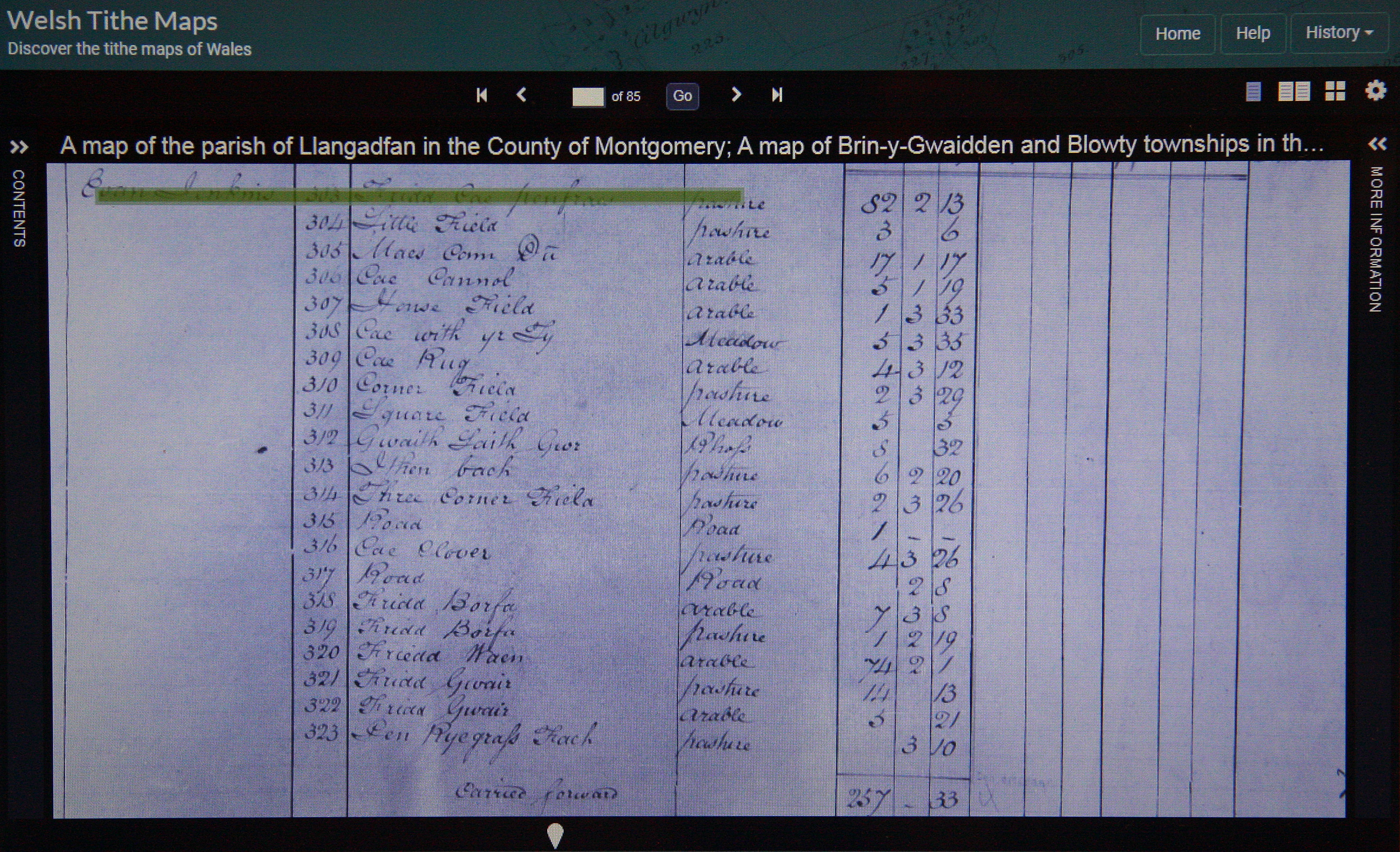

%20IMG_0394A%20-%201%2025000.jpg)
%20IMG_0400A%20-%20Six-Inch.jpg)
%20-%20LIDAR%20hill%201.jpg)

%20IMG_1063A%20-%201%2025000.jpg)
%20IMG_1058A%20-%20Magic%20Maps.jpg)
%20-%20LIDAR%20summit%202.jpg)

%20IMG_1032A%20-%201%2025000.jpg)
%20IMG_1040A%20-%20Tithe.jpg)
%20IMG_1046A%20-%20apportionments.jpg)
%20-%20LIDAR%20hill%204.jpg)

%20IMG_1010A%20-%201%2025000.jpg)
%20IMG_1016A%20-%20Tithe.jpg)
%20IMG_1025A%20-%20apportionments.jpg)
%20-%20LIDAR%20hill%203.jpg)
%20-%20LIDAR%20summit%201.jpg)