Showing posts with label Rob Woodall. Show all posts

Saturday, 2 May 2020

Mapping Mountains – Trimble Surveys – Esgair Wen


05.01.20  Lan Fawr (SN 692 501), Cerrig Cyffion (SN 689 479) and Esgair Fawr (SN 681 482)  

Cerrig Cyffion (SN 689 479)

Within the updated list of the Y Pedwarau – The 400m Hills of Wales, Lan Fawr has been reclassified from a 400m Sub-Pedwar to a Pedwar, as such it is a new P30.  This newly crowned status is based on OS Maps 5m bwlch contouring and is of interest to a number of people, including Rob Woodall, who has visited all Welsh mainland P30s; which is an incredible achievement.  Therefore, as Rob had not visited this hill, he wanted to. 

Rob arrived Saturday evening and we were soon in The Raven enjoying an excellent meal.  We were away by 7.30am on Sunday heading to the wild landscape south of Llanddewibrefi and north of the small community of Ffarmers.

Weather conditions were not ideal, with mist and drizzle for the majority of the journey.  However, as we set off walking the mist hugging the opposing ridge of Garn Fawr (SN 668 502) slowly lifted and pushed further inland.

We planned a three hill circuit around the upper reaches of the Afon Cothi, with Lan Fawr and Cerrig Cyffion being of particular surveying interest with both hills considered for reclassification to Pedwar status.  Hopefully the Trimble would give a definitive result for each.

A track led from the last farm in the valley; Blaen-Twrch, making steady progress up the south-western flank of our first hill of the day; Lan Fawr.  Encircling us gloom pervaded, with higher summits cloaked in mist with banks of mist rolling in from the lowlands to our south heralding intermittent drizzled conditions.

Heading to the hill

We spent quite some time at the summit of Lan Fawr taking three data sets with the last beside the remains of a flattish cairn which was our favoured position for the high point.  During data collection a number of sheep walked our way, standing facing us either expectant of feed or just being inquisitive.  They made an appealing foreground to the misted hills in the distance.

Gathering data at the summit of Lan Fawr

Being watched

The hill’s grassed north-eastern ridge soon led us down to a tussocky bwlch, and soon the Trimble was positioned on top of my rucksack gathering data.  As the equipment gathered its allotted data we stood back and looked out on the mass of unsavoury but nevertheless beautiful yellow tinged land between us and the haven of green grass atop a small ridge which would take us down to a track leading toward our second hill of the day; Cerrig Cyffion.

Gathering data on the bwlch area of Lan Fawr

Once data were gathered and stored I closed the Trimble down, packed it away and followed Rob as he contoured around the upper easterly flank of Lan Fawr, eventually loosing height down through dark browned bracken to a reed invested stream where he easily jumped its watery depths.  I however made an unceremonious landing with my left foot slipping on the bank and dangling over the stream which resulted in Rob trying to hold on to me and the two of us landing heap like on the ground.

Leaving Lan Fawr and heading toward Cerrig Cyffion

By now each drizzly spell would be replaced by a semblance of clarity and semi-dryness, and considering the surrounding conditions we were lucky as all surveys were conducted clear of mist and it did not hamper navigation.

Making progress toward Cerrig Cyffion

We gained height above the stream with Rob unsurprisingly leading the way seemingly at only a quarter of his normal pace as I huffed and puffed on the uphill section.  A muddied track led us down to a stream crossing where an old track led past the ruined Blaen Cothi.  This old house must have been a wild place to make a life.

Blaen Cothi with Cerrig Cyffion in the background

The muddied track met a more recent construct which wound its way around the northern and eastern flank of Cerrig Cyffion, we soon left it and opted for a path leading up its northerly ridge.  By the time I reached the summit Rob was standing beside one of a number of small rocks jutting out of the ground and had declared this the high point.  The Trimble was soon aligned with this, a measurement offset taken and away it went, gathering its allotted data.  During data collection I stood and munched on a banana, my only sustenance of the walk.

Gathering data at the summit of Cerrig Cyffion

The bwlch adjoined to Cerrig Cyffion is just to the north-west of the continuation of the track which had wound its way higher on the hill.  This bwlch was particularly unpleasant with large tussocks predominating.  We spent a number of minutes assessing the bwlch and visually followed the hill to hill traverse to a point that we judged bisected the valley to valley traverse and used an upended red animal feed bucket as an improvised tripod, and as my rucksack was positioned on its top and the Trimble atop this it gave a 0.70m offset between its internal antenna and the ground at its base and was sufficiently high enough to clear the large tussocks.  Just one hill now remained.

Heading toward the bwlch of Cerrig Cyffion

Gathering data at the bwlch of Cerrig Cyffion

The Trimble set-up position at the bwlch of Cerrig Cyffion

Esgair Fawr is the highest of the three hills we visited and between us and its summit was another large mass of tussocks and bog.  To get there we circumvented the edge of a conifer plantation and contoured grassed slopes toward the bwlch.  This gave an advantage point to look down and judge where the critical point lay.  As Rob ventured further in to the mass of bog and tussocks I assessed the ground and chose a spot and placed the rucksack on top of a tussock and waited for Rob to re-join me with his assessment.  He considered the position good and we both then stood an appropriate distance away as data were gathered.

Gathering data at the bwlch of Esgair Fawr

It was a steady plod to the summit of Esgair Fawr and Rob was there waiting for me when I arrived.  The high point is at the base of a fence that is on top of a grassed over stone wall.  As the grassed stone wall was considered unnatural I positioned the Trimble on what we judged the highest natural point of the hill and the day’s eighth data set was gathered.

Gathering data at the summit of Esgair Fawr

All that remained was to join our downward track and head back to the awaiting car.  However, Esgair Fawr has a twin map heighted top which stared back at us as it balanced above a small rock carved drop.  Aled had LIDARed this hill and the point that had just been Trimbled proved to be the higher, we also thought this visually, but as we were there, Rob suggested a last data set and soon the Trimble was placed aligned with this tops highest point and quietly beeping away gathering data.

Once the Trimble was packed away we headed toward the track and its steep zig zags forever downward to the car.  It was good to get these hills surveyed, and especially Lan Fawr and Cerrig Cyffion as these two hills could be 400m Sub-Pedwarau or indeed Pedwarau.  It was also good to catch up with Rob, without whom I would have waited another few months before attempting this walk which had been penciled in as one of this year’s priority surveys.

LIDAR image of Lan Fawr (SN 692 501)


Postscript:

Since visiting these hills full LIDAR coverage is now available.  The LIDAR (Light Detection & Ranging) technique produced highly accurate height and positional data that is now freely available for England and Wales.  Consequently the numerical details for these hills have been analysed using this technique, resulting in LIDAR being prioritised over some of the results produced by surveying with the Trimble GeoXH 6000. 


Survey Result:


Lan Fawr 
 
Summit Height:  427.4m (converted to OSGM15, Trimble GeoXH 6000)

Summit Grid Reference:  SN 69244 50156 (Trimble GeoXH 6000)

Bwlch Height:  398.2m (LIDAR)

Bwlch Grid Reference:  SN 69489 50456 (LIDAR)

Drop:  29.2m (Trimble GeoXH 6000 summit and LIDAR bwlch) (Pedwar reclassified to 400m Sub-Pedwar)

Dominance:  6.83% (Trimble GeoXH 6000 summit and LIDAR bwlch)


Cerrig Cyffion 
 
Summit Height:  414.8m (converted to OSGM15)

Summit Grid Reference:  SN 68924 47937

Bwlch Height:  386.1m (converted to OSGM15)

Bwlch Grid Reference:  SN 68829 47667

Drop:  28.7m (400m Sub-Pedwar status confirmed)

Dominance:  6.91%


Esgair Fawr 
 
Summit Height:  412.4m (converted to OSGM15)

Summit Grid Reference:  SN 68189 48249

Bwlch Height:  361.5m (converted to OSGM15)

Bwlch Grid Reference:  SN 68287 47838

Drop:  50.9m

Dominance:  12.34%


Monday, 13 May 2019

Mapping Mountains – Trimble Surveys – Y Berwyn


Carole Engel Completes the Welsh Humps

24.11.18  Pen y Boncyn Trefeilw (SH 962 283, previously Trimbled), Stac Rhos (SH 969 279, previously Trimbled), Foel Cedig (SH 981 283, previously Trimbled) and Y Groes Fagl (SH 988 289, previously Trimbled)


With the hill meet organised by Alex Cameron at the old Workhouse on the outskirts of Llanfyllin being so close to the Y Berwyn it gave an opportunity for a number of people to visit Foel Cedig, whose qualifying summit for a number of lists, including the Marilyns, Humps, Simms, Hewitts, Pellennig, Yr Uchafion and Nuttalls was earlier this year relocated from Cyrniau Nod.

As a part of this Carole Engel had decided to postpone her Welsh Hump completion for a week and re-scheduled this to coincide with the hill meet.  By doing so there was a prospect of being joined on top of Foel Cedig by a number of other baggers, but with many different agendas and with people approaching this hill from different directions and starting their ascents at different times, it would be interesting to see how many gathered at this summit when Carole was having her celebration.

Having attended the Friday evening meal at the Workhouse I drove back home in wet conditions through mist and thick fog and wondered if the weather gods were to put a dampener on proceedings for the following day.  Thankfully although the weather was grey and murky, the rain resisted temptation and the tops were clear of low clag.

I met Alan Caine at the Workhouse just before 9.00am and we drove in two cars to the car park at the north end of Llyn Efyrnwy (Lake Vyrnwy) where Carole, and Jeff and Enid Parr were already waiting.  It was good to see all three, and this is one of the joys of occasionally dipping in to the community of hill baggers as friends have been made and will be kept, and all three; Carole, Jeff and Enid are people who I look forward to meeting up with time and again.

Having donned my winter wellies I then drove the five of us to the top of Cwm Hirnant and parked opposite the gauged out track that leads toward the summit of Foel Cedig.  This track eases passage to these heather clad hills, and if not for it the task of bagging these hills would be a daunting one.

On our way to Foel Cedig we visited the summits of Pen y Boncyn Trefeilw and Stac Rhos, which were later in the day surveyed by Alan Dawson with his Leica RX1250.  To our east the grey morning clag was just grasping on to the upper part of Foel Cedig, but this would lift as the morning progressed.

Carole with Foel Cedig in the background

During our journey on the track beside the moorland Alan Caine zoomed off in to the heather and bog to bag any summit going, with Bridges and one or two ‘Deleted Tops’ in the Nuttalls book all being fair game.

Approaching Foel Cedig Carole led the way through the heather as I tried to keep up with a digi-camcorder in hand, she reached the top and completed the Welsh Humps and immediately set about logging her ascent online, which made me smile.  One quick wind-blown interview later and the bottles were opened and cake passed round.

As we arrived at the summit Denise and Richard McLellan were just about to leave, they turned back and remained with us as more and more people started to appear from different directions.  Richard’s ascent of Foel Cedig was also of significance as he was re-completing the Marilyns and him and Carole sat centre stage on the little rocky knoll that makes up the high point as everyone else gathered around for the customary summit photograph.

Richard's re-completion of the Marilyns on top of Foel Cedig

The walk back on the track was enjoyable and we reached my car 4½ hours after setting off.  It was good to see Carole, Jeff and Enid again and many others who were on the summit of Foel Cedig and also at the Workhouse, and thanks to Alex for organising the hill meet and Carole’s invitation to join her on her special day of celebration in completing the Welsh Humps.

Celebratory gathering at the summit of Foel Cedig


Saturday, 7 April 2018

Mapping Mountains – Trimble Surveys – Cadair Idris


Rob Woodall Completes the Welsh Mainland Tumps

18.02.18  Pared y Cefn Hir (SH 661 148, only bwlch Trimbled), Ffridd Bellau Nant y Gwyrddail (SH 665 139, previously Trimbled) and Ffridd Las (SH 660 139, previously Trimbled)


Ffridd Las (SH 660 139)

Today was quite a momentous one in the annals of hill bagging as Rob Woodall completed the Welsh mainland Tumps, a staggering undertaking with 2,271 hills listed as of the time of completion.

The hill Rob chose for this completion remains unnamed on Ordnance Survey maps, and is known as Ffridd Las by the farmer who grazes sheep on the hill, it is listed as Pen Llynnau Cregennen in the Tumps.

The farmer who grazes Ffridd Las lives at the small farm house of Ffridd Boedel, which is situated beside and directly below the hill to its north-west, and on my way to the lakeside car park where Rob had suggested we all meet, I called at this house and met Carys Lloyd.  We chatted for a number of minutes and I explained my interest in upland place-name research, she kindly suggested I call back nearer lunchtime as her husband; Arwyn, would be in and could help me.

A few minutes later I drove in to the lakeside car park adjacent to the double lakes of Llynnau Cregennan, the day looked fair until early afternoon when light rain was forecast.  This at least was more favourable when compared to recent weather reports as persistent rain and hill mist had been forecast for the morning and remainder of the day.

The positioning of Llynnau Cregennan are beautiful as they sit nestled in the landscape with the looming profile of Pared y Cefn Hir overlooking to the north-east and the higher satellite peaks of Cadair Idris to their south-east.  But it is Pared y Cefn Hir that stands out, butted skyward it defies its relatively lowly height.  Whilst Ffridd Las is almost inconsequential in comparison, a grassed domed small hill beside the minor road that skirts the lakes.  However, this is the appealing factor of the Welsh P30s as they take in small and high hills alike, rock strewn giants and mere grassed grazing fields, well-trodden paths and seldom visited places, and it is their variety that encourages investigation.

Pared y Cefn Hir and the northerly of the Llynnau Cregennan

Rob had suggested extending his walk over Pared y Cefn Hir and its adjacent hill of Bryn Brith, before visiting Ffridd Bellau Nant y Gwyrddail, followed by his last hill; Ffridd Las.  I decided to bi-pass the first two hills of the walk and join the festivities on the last two; this would give me time to visit the small farm house of Ffridd Boedel where I hoped to meet Arwyn Lloyd and confirm the name of the hill that Rob was finishing on.

As the party set off toward Pared y Cefn Hir I remained in the car park chatting with Gordon Adshead who, like me, planned on visiting the last two hills at his leisure.  The morning was ideal for such a walk with the tops clear of clag and a gentle winter light adding substance to the beautiful landscape.

As Rob and friends began to get strung out on their way up Pared y Cefn Hir I sauntered down to the larger and more northerly of the double lakes and watched as a cloud blanket cascaded over the cliffs of Mynydd Moel, a slow and delicate ebb of morning mist following the upper contours of the hill.

Rob and party heading up Pared y Cefn Hir

Although I hadn’t planned on doing so I realised that with time on my hands I could gather a data set from the critical bwlch of Pared y Cefn Hir, this is positioned at the outflow of the northern and larger lake.  This position had been surveyed in November 2012 when along with John Barnard and Graham Jackson we spent two days surveying the summits of Pared y Cefn Hir and Bryn Brith and three potential positions of the higher of these two hills connecting bwlch.

Gathering data with the Leica GS15

As I approached the outflow I looked up and Rob and friends were just cresting the summit ridge of Pared y Cefn Hir, I positioned the Trimble on the upper part of the concrete surround at the outflow to the northern lake, thankfully the concrete surround was just wide enough for the Trimble to be positioned without any possibility of being dislodged.

After measuring the offset between the Trimble’s internal antenna and the gravel and rock at the base of the water I stood back and waited for it to attain the 0.1m accuracy level before data should be logged, this was achieved relatively quickly and after pressing ‘Log’ I wandered away from the equipment’s quiet beeps and happily contented myself with taking photos across the water to the grassed and curved profile of Ffridd Las.

The bwlch of Pared y Cefn Hir

Initially I planned on collecting five minutes of data, but as I had no time constraint I thought ten minutes would be sufficient.  During data collection a couple walked my way on the narrow minor road, they stopped and we chatted, by the time they headed off over 20 minutes of data had been gathered, I then decided that a 30 minute data set would be good!

Gathering data at the critical bwlch of Pared y Cefn Hir

Once data were stored and the Trimble packed away I walked up the road to Ffridd Boedel where Arwyn met me in his slippers, after explaining my interest in the names of adjacent hills he put his boots on and we spent a contented 30 minutes above his farm talking about the hills, their names, the ffriddoedd and his life as a farmer.

Arwyn Lloyd of Ffridd Boedel

I only left when we spotted the large party descending Pared y Cefn Hir and taking the path heading east around the northern shore of the larger lake, realising that they were not heading up the minor road where I planned on joining them I thanked Arwyn for his time and then headed toward the summit of Ffridd Bellau Nant y Gwyrddail.

As I approached the summit of Rob’s penultimate Welsh mainland Tump the strung our party were rounding the shore of the southerly lake and heading up the south-west flank of the hill.  They were soon on the summit.

Approaching the summit of Ffridd Bellau Nant y Gwyrddail

At the summit of Ffridd Bellau Nant y Gwyrddail

All that remained was the walk back down from the summit of Ffridd Bellau Nant y Gwyrddail and the short walk over toward the summit of Ffridd Las, the last hill of many for Rob, all 2,271 of them!

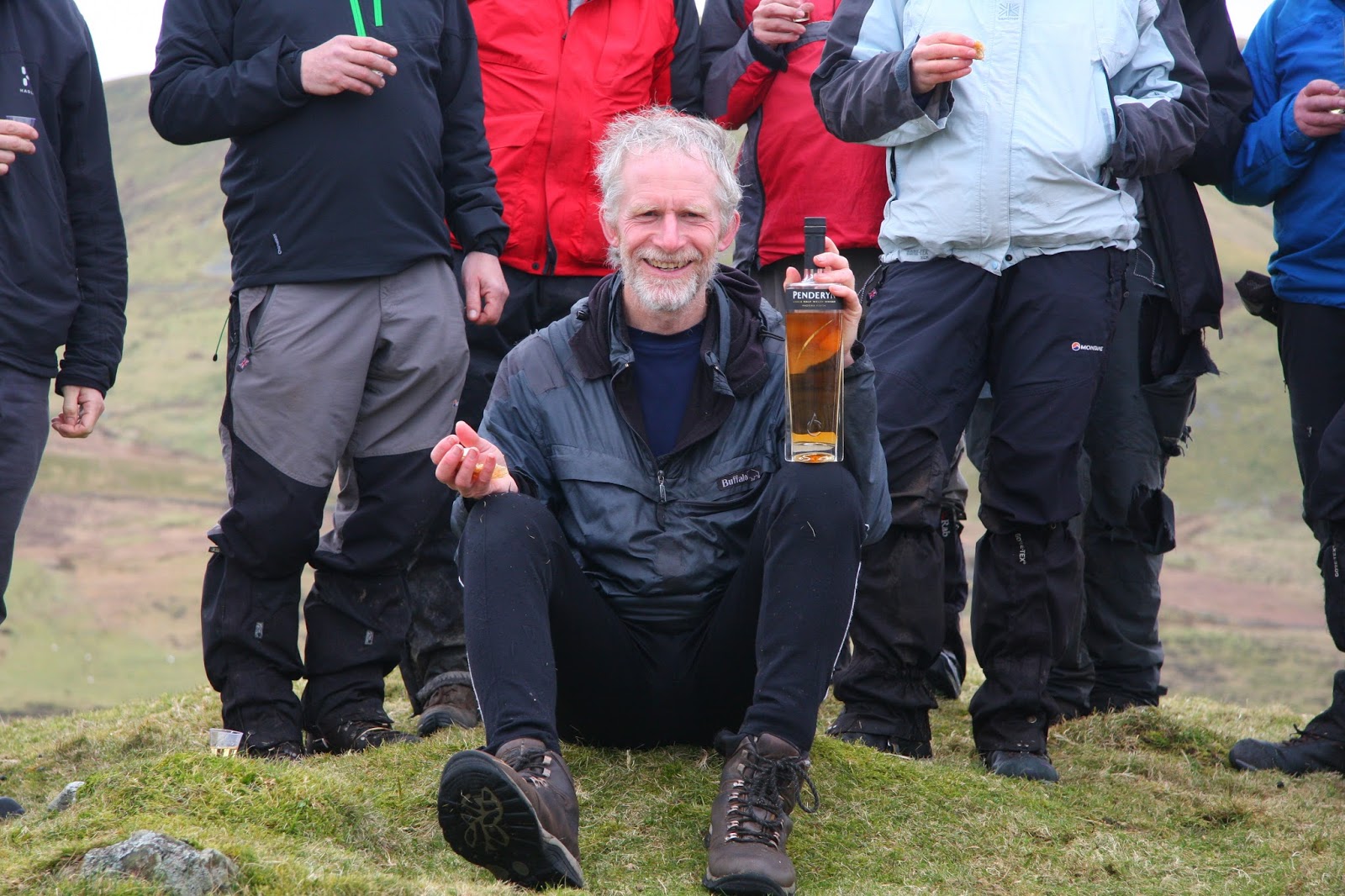
Rob was greeted at the summit of Ffridd Las by 14 people with the customary arch of ceremonial walking poles leading toward the high point of the hill; this was a fitting end to an unprecedented achievement.  We stood and sat beside the summit sampling a variety of cake toasting Rob’s latest amongst many incredible achievements.

At the summit of Ffridd Las

Rob completes the Welsh mainland Tumps on the summit of Ffridd Las

Visiting the Welsh P30s is something that I have enjoyed for many years, their variety seems to have no bounds, and they have brought me so many enjoyable experiences, with each one however small in height or grand in stature bringing its own unique charm and ambiance.  To have visited them all on the mainland must be such a fulfilling experience and my congratulations go out to Rob for being the first person to have done so.    
 
   
Survey Result:


Pared y Cefn Hir

Summit Height:  383.1m (converted to OSGM15, from previous Leica GS15 survey) (Sub-Trichant reclassified to Trichant)

Summit Grid Reference:  SH 66199 14885 (from previous Leica GS15 survey)

Bwlch Height:  233.7m (converted to OSGM15, Trimble GeoXH 6000)  233.7m (converted to OSGM15, Leica GS15)

Bwlch Grid Reference:  SH 65822 14423 (Trimble GeoXH 6000 and previous Leica GS15 survey)

Drop:  149.4m (from previous Leica GS15 survey)

Dominance:  39.00% (from previous Leica GS15 survey)


Thursday, 22 March 2018

Rob Woodall Completes Mainland Welsh TUMPs


Rob Woodall – UKHillwalking Article

UKHillwalking recently published an article on Rob Woodall’s completion of the Welsh mainland Tumps.  The original article and a link to it on the UKHillwalking website appear below.


Rob Woodall Completes Mainland Welsh TUMPs
by Myrddyn Phillips 21/Feb/2018


In mid February, over achieving list completer Rob Woodall became the first person to climb all 2271 TUMPs on the Welsh mainland. Tump (Thirty and Upward Metre Prominences) status is simply any hill with a minimum 30m drop on all sides, no matter its summit height. Some are full-sized mountains, others mere molehills - but the challenge of getting around them all is obvious!
Few baggers anywhere can compare with Rob Woodall and his extraordinary exploits. He was the first person to complete the daunting challenge of the 1556 hills listed in the Marilyns (see the UKH interview here), and first to visit the remaining Ordnance Survey trig pillars – all 6190 of them (he's now boosted the latter to 6194, as four destroyed pillars have been rediscovered).

Rob Woodall celebrating at the summit of Ffridd Las

In early January Rob set two ambitions for the year ahead - one of which was to complete the Welsh mainland Tumps. This was achieved on a small hill at the base of Cadair Idris on a pleasant and thankfully dry day in mid-February with friends and bottles of varied beverage in attendance.

The hill that Rob chose as his final Welsh mainland Tump remains unnamed on Ordnance Survey maps but is known as Ffridd Las, with the name of Pen Llynnau Cregennen used in the Tumps listing. It has a map height of 279m and is positioned at SH660139 overlooking the double lakes of Llynnau Cregennan.

Ffridd Las was justly fitting to finish on as it proved reminiscent of so many of the Welsh Tumps. Situated throughout Wales, many are tranquil and seldom visited hills, this being one of their appealing aspects, however Ffridd Las has a special beauty to it as it is positioned against the shore of the double lakes with the bulk of Tyrau Mawr, one of the satellite peaks of Cadair Idris, rising behind as a dramatic backdrop.

Rob and friends heading up Pared y Cefn Hir

Rob combined Ffridd Las with some of its higher neighbours, with Pared y Cefn Hir, Bryn Brith and Ffridd Bellau Nant y Gwyrddail (listed as Bryn y Gregennen in the Tumps) all visited before the celebratory last hill was reached. This gave a good circular walk based around Llynnau Cregennan. The last hill of the day was celebrated with hill walking friends, a Penderyn Single Welsh Malt Whisky and numerous cakes.

To complete such a challenge must be a wonderful experience. So many hills of such varied height, small and high alike, can all qualify, as the criterion for Tump (Thirty and Upward Metre Prominences) status is simply any hill with a minimum of 30m of drop on all sides, irrespective of its summit height.

The Tumps take in the whole of Britain and were first published by Mark Jackson in 2009, including data from a number of other list compilers. In all there are 2271 mainland Tumps listed in Wales (at the time of completion), with an overall Welsh total including island Tumps exceeding 2340.

It has been another incredible undertaking by Rob and one that leaves the author of this article a wee bit jealous as I have an affinity for these wonderful Welsh P30 hills. Good on Rob for his incredible achievement and many congratulations on becoming the first person to complete the Welsh mainland Tumps!