Showing posts with label Yr Arwydd. Show all posts

Wednesday, 3 March 2021

Mapping Mountains – Significant Name Changes – 100m Twmpau and Y Trechol – The Dominant Hills of Wales


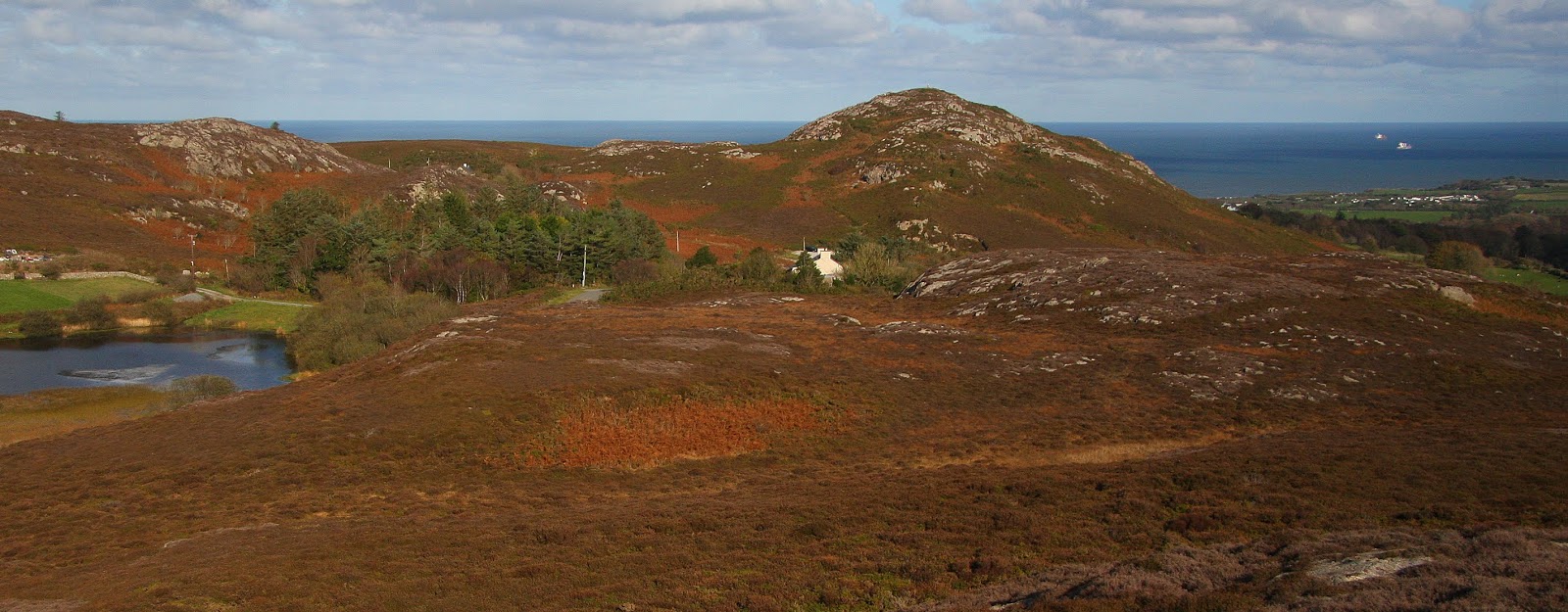
Yr Arwydd (SH 472 854) 

There has been a Significant Name Change to a hill that is listed in the 100m Twmpau and Y Trechol – The Dominant Hills of Wales, with the summit height and its location, the drop, dominance and status of the hill confirmed by a Trimble GeoXH 6000 survey conducted by Myrddyn Phillips. 

Yr Arwydd (SH 472 854)

The criteria for the two listings that this name change applies to are:

100m Twmpau - Welsh hills at or above 100m and below 200m in height with 30m minimum drop, with an accompanying sub list entitled the 100m Sub-Twmpau with the criteria for this sub category being all Welsh hills at or above 100m and below 200m in height with 20m or more and below 30m of drop, with the word Twmpau being an acronym standing for thirty welsh metre prominences and upward. 

The 100m Twmpau by Myrddyn Phillips

Y Trechol – The Dominant Hills of Wales – Welsh P30 hills whose prominence equal or exceed half that of their absolute height.  With the criteria for Lesser Dominant status being those additional Welsh P30 hills whose prominence is between one third and half that of their absolute height.  The list is authored by Myrddyn Phillips with the Introduction to the start of the Mapping Mountains publication of this list appearing on the 3rd December 2015, and which is now available in its entirety on Mapping Mountains in Google Doc format. 

Y Trechol - The Dominant Hills of Wales by Myrddyn Phillips

The hill is adjoined to the Ynys Môn group of hills, which are situated in the north-western part of North Wales (Region A, Sub-Region A1), and it has the A5025 road to its north-east and a minor road to its immediate south-east, and has the village of Llannerch-y-medd towards its west south-west and the village of Moelfre towards its east north-east. 

The hill originally appeared in the 100m P30 list on Geoff Crowder’s v-g.me website under the name of Mynydd Bodafon, with an accompanying note stating; aka Yr Arwydd.


Mynydd Bodafon178mSH472854114263aka Yr Arwydd. Marilyn. Clem/Yeaman. Trig pillar.


During my early hill listing I paid little regard to name placement on the map, or the meaning of names and to what feature the name was appropriately applied to.  Therefore I prioritised names for listing purposes that I now understand are either inappropriate or where another name is viewed as being more appropriate. 

The two names of Yr Arwydd and Mynydd Bodafon are shown on the contemporary Ordnance Survey 1:25,000 Explorer map, with the former positioned adjacent to the summit of this hill.  The latter name is associated with the farms of Bodafon-y-glyn and Bodafon Wyn which are positioned westward from the summit of this hill.  The Tithe map indicates that Mynydd Bodafon is the mountain land associated with Bodafon farm that also takes in the other two adjacent P30s of Pen y Castell (SH 468 853) and Barclodiau (SH 466 848) and therefore this is a cynefin name, with the Six-Inch and 1:25,000 maps indicating that the name Yr Arwydd is associated with just that of this hill.  Therefore, as a hill name takes precedence over a cynefin name it is Yr Arwydd that is now being used for listing purposes for this hill. 

Extract from the Ordnance Survey 1:25,000 Explorer map

Therefore, the name this hill is now listed by in the 100m Twmpau and Y Trechol – The Dominant Hills of Wales is Yr Arwydd, and this was derived from the contemporary 1:25,000 Explorer map, with the Ordnance Survey series of Six-Inch maps and the Tithe map also consulted. 


The full details for the hill are: 

Group:  Ynys Môn 

Name:  Yr Arwydd

Previously Listed Name:  Mynydd Bodafon 

OS 1:50,000 map:  114

Summit Height:  177.5m (converted to OSGM15)

Summit Grid Reference:  SH 47242 85417

Bwlch Height:  not applicable

Bwlch Grid Reference:  not applicable 

Drop:  177.5m

Dominance:  100.00%


Myrddyn Phillips (March 2021)


Sunday, 19 May 2019

Mapping Mountains – Significant Name Changes – 100m Twmpau


Yr Arwydd (SH 388 824)

There has been a Significant Name Change to a hill that is listed in the 100m Twmpau, with the summit height determined by a survey with the Trimble GeoXH 6000 conducted by Myrddyn Phillips, which took place on the 28th October 2018.

The summit of Yr Arwydd is in the background on the right

The criteria for the list that this name change applies to are:
               
100m Twmpau - Welsh hills at or above 100m and below 200m in height with 30m minimum drop, with an accompanying sub list entitled the 100m Sub-Twmpau with the criteria for this sub category being all Welsh hills at or above 100m and below 200m in height with 20m or more and below 30m of drop, with the word Twmpau being an acronym standing for thirty welsh metre prominences and upward.

The hill is adjoined to the Ynys Môn group of hills, which are situated in the north-western part of North Wales (Region A, Sub-Region A1), and it is positioned with the B5112 road to its south-east, and has the small community of Carmel to its south-west.

When the origin 100m height band of Welsh P30 hills were published on Geoff Crowder’s v-g.me website, this hill was listed under the partly invented and transposed name of Bryn Carmel, with an accompanying note stating; Name from hamlet to the South-West.


Bryn Carmel
116m
114
262
Trig pillar. Name from hamlet to the South-West


During my early hill listing I thought it appropriate to either invent a name for a hill, or use a name that appeared near to the summit of the hill on Ordnance Survey maps of the day.  My preference was to use farm names and put Pen, Bryn or Moel in front of them or as in this instance transpose the name of the small community to the south-west of the summit of the hill and put the word Bryn in front of it.  This is not a practice that I now advocate as with time and inclination place-name data can be improved either by asking local people or by examining historic documents, through this form of research an appropriate name for the hill can usually be found.

Extract from the Ordnance Survey 1:25,000 Explorer map

As the summit of this hill comprises bounded land the details for it were examined on the Tithe map.  The term Tithe map is generally given to a map of a Welsh or English parish or township and which was prepared after the 1836 Tithe Commutation Act.  This act allowed tithes to be paid in cash rather than goods.  The Tithe maps gave names of owners and occupiers of land in each parish and importantly for place-name research they also included the name of enclosed land.  This enclosed land is usually based on a field system, however not every field is given a name, but many are and especially so in Wales.

Extract from the Welsh Tithe Maps website showing the comparison details taken from the Ordnance Survey Six-Inch map

The enclosed land where the summit of this hill is situated is given the number 30a on the Tithe map, this can be cross referenced against the apportionments; it is these apportionments that give the name of the owner or occupier of the land as well as the name of the land.  The land where the summit of this hill is situated is named as Yr arwydd in the apportionments, with the details on the Tithe map appearing in the parish of Llechgynfarwy and in the county named as Anglesey.

Extract from the apportionments

After visiting this hill I asked a person who was working outside one of the houses in Carmel if they knew where the local farmer lived, I was directed up the lane to a bungalow which is positioned beside the field where the summit of the hill is situated.  Having knocked on its door, Medwen Roberts opened it and greeted me with a smile, I said hello and introduced myself and explained my interest in her field and asked if she knew a name for the hill or the field where its summit is situated, she told me the hill has no name but the field is known as Yr Arwydd.  During our conversation Medwen explained that this is her field and that she had lived in Carmel for 60 years and is now aged 79.  Before leaving I walked to the gate with Medwen that gives access to her field from her bungalow and she kindly stood beside it whilst I took a series of photographs.

Medwen Roberts

Therefore, the name this hill is now listed by in the 100m Twmpau is Yr Arwydd, and this was derived from the Tithe map and substantiated by local enquiry.


The full details for the hill are:

Group:  Ynys Môn

Name:  Yr Arwydd

Previously Listed Name:  Bryn Carmel 

OS 1:50,000 map:  114

Summit Height:  116.9m (converted to OSGM15)

Summit Grid Reference:  SH 38800 82447

Bwlch Height:  c 79m

Bwlch Grid Reference:  SH 40939 83373 (I)
 
Drop:  c 38m


Myrddyn Phillips (May 2019)


Monday, 29 April 2019

Mapping Mountains – Trimble Surveys – Mynydd Twr


28.10.18  Yr Arwydd (SH 472 854), Pen y Castell (SH 468 853) and Barclodiau (SH 466 848)  

Yr Arwydd (SH 472 854)

I’d looked out on the hills comprising Mynydd Bodafon six days prior to today’s visit and had then hoped to reach them, but daylight hours, or lack of, dictated that I could not, and with their rock strewn profiles now edged in my memory I did not need a second chance to visit.  However, as I wanted to survey three summits and also then visit and survey Mynydd Eilian further to the north, I could not linger and although the afternoon and its sunshine was one to savour, a more investigative visit to these hills would have to wait for another day, as today it was going to be a quick up, down, up, down, up and down visit, but even with this mentality these hills did not disappoint.

Arriving beside Gors Fawr; the small lake at the base of these three hills, is like stepping back to a land stilled in time, where the ebb and flow of life is taken more leisurely, where the tranquil surrounds of water and hill also add and accentuate the beauty of such a place.

Gors Fawr

Sometimes when writing posts’ relating to my Trimble surveys it is hard to find new things to say, I also ask myself if this matters as I endeavour to treat each post as a separate entity, but still, on occasion one post does seem to merge in to another.  It is also hard to create quality when so many posts are written, I sometimes wish that I had more time to concentrate on these posts, to re-draft and edit, but time is a premium I seldom have, and therefore I suspect my writing on this occasion will not do the land of this place justice as the hills comprising Mynydd Bodafon and its surrounds are a thing of compact beauty.  If given the chance please visit, it is well worthwhile.

These three hills are rugged in nature with rock, heather and gorse dominating.  I knew paths existed but was unsure exactly where, but as most hills have paths on them, and as most of these paths aim toward the summit I did not have much concern about where to find them.

I set off having parked my car beside Gors Fawr and wandered up a track leading to one or two houses that dot the landscape hereabouts.  Leaving this track I followed a path heading north-east toward the base of the highest of these three hills; Yr Arwydd, which forms a part of the larger Mynydd Bodafon.

The path brought me to a small car park where a path carved its way upward through the vegetated hillside.  Although only a short ascent I thought I made good time and soon arrived at the summit, which is crowned with a trig pillar.  On my way toward the hill I’d seen a few small figures on its high point but no one was there when I arrived, which reassured me for the survey I was about to conduct, as having to ask someone if they would be good enough to stay away from the summit for however many minutes whilst the Trimble gathers its allotted data is not one of my favoured things to do.

The high point of this hill is beside the trig pillar and consists of rock, and it was relatively easy to judge which part of the rock was the highest.  Once the Trimble was wedged in place gathering its allotted data I sat a few metres below and away from it and savoured the warmth of autumn as the sun cast down.  Soon however I had to do what I do not like doing as within two minutes of activating the Trimble a walker appeared, I called over explaining what I was doing and asked if they would mind waiting about eight minutes until the survey and its ten minute allotted data set was complete.  Thankfully the walker had no problem with this and sat looking out at the view, and seemingly as I, more than happy to do so.

Gathering data at the summit of Yr Arwydd

Leaving the summit I chatted with the walker for a number of minutes, he was a botanist and told me about discovering a new fern that had not been documented in Britain before and pointed to where he had found it.  I explained about the Trimble and my hobby of surveying hills, we smiled at each other in a knowing way.  Eccentricity, obsession or just plain hobby, I do not care as I often marvel at what people do and their passion for things that others may think as unusual.

It was only a short walk down the path toward the small car park, on my way I looked out across to Pen y Castell; my next hill, and tried finding a path amongst its heathered slopes that would ease my upward progress.  I thought I’d spotted one, but when I walked up the continuation of the track from the car park and however much I peered at the heathered slopes no path materialised.  In such situations one has few options, and mine were limited to trying to find a path on the other side of the hill or going for it.  I knew even before I asked myself this question what I would do, and another minute later I wondered if I had chosen wisely as I was immersed in bracken and brambles with a steep bit of slope directly in front of me.  Thankfully what could have proven to be an awkward situated was soon overcome and I was over the worst of this part of the hill, and by keeping to the rock strewn slopes above passage upward was eased with only the occasional foray in to the heathery depths necessitated.

Pen y Castell from Yr Arwydd

Yr Arwydd from Pen y Castell

I was soon at the summit and had the Trimble aligned with its high point, it remained in its place for five minutes of data collection whilst I sat below it on a convenient rock eating a well-earned sandwich.

Gathering data at the summit of Pen y Castell

I thought of retracing my inward route, but it was a shorter distance to continue traversing the hill down to where a few houses lay below.  However, this downward route proved pathless, or at least was so on this particular day, I gathered momentum as gravity and a need to press on became my motivators and continued downward however prickly the copious amounts of gorse and bramble became, emerging beside a house whose owner was plastering its side, he looked up and asked if I had just come down from the hill, I turned and looked back up and said that it was a little rough, he said that not many people come down that way, saying there used to be a shepherds path on the hill, which is now overgrown.

I chatted with the man for a number of minutes and he kindly gave me a detailed route where the path lay for my next hill; Barclodiau.  Thanking him I pressed on down the track toward where my car was parked and onward directly opposite it to a narrow path amongst the heather, this I followed until it diverged, I followed it on the right as directed, and this led to Gors Arian, which today was slumbering in its marshy depths.  From here the path again diverged and as again directed I followed it left and this brought me straight up to the summit, this proved an easy way up what otherwise would have resulted in another rough ascent.

Tan Castell, Pen y Castell and Yr Arwydd from Barclodiau

The high point of Barclodiau consists of rock positioned a few metres from a small wind shelter, and as the Trimble gathered its allotted data I again stood and savoured the view, as I had done on countless hills over the last five years.  But views and hills are things never to tire of.

Gathering data at the summit of Barclodiau

Once the Trimble was safely packed away I scampered off down the path through the heather and emerged next to my car a few minutes later.  What a stunning small walk this proved to be, and these hills certainly did not disappoint.  Next stop Mynydd Eilian (SH 472 917).


Survey Result:


Summit Height:  177.5m (converted to OSGM15) (confirmed as higher than Mynydd Eilian [SH 47282 91719]

Summit Grid Reference:  SH 47242 85417

Bwlch Height:  N/A (sea)

Bwlch Grid Reference:  N/A (sea)

Drop:  177.5m

Dominance:  100.00%


Pen y Castell

Summit Height:  168.9m (converted to OSGM15, Trimble GeoXH 6000)

Summit Grid Reference:  SH 46823 85324 (Trimble GeoXH 6000)

Bwlch Height:  138.1m (LIDAR)

Bwlch Grid Reference:  SH 46971 85430 (LIDAR)

Drop:  30.9m (Trimble GeoXH 6000 summit and LIDAR bwlch)

Dominance:  18.28% (Trimble GeoXH 6000 summit and LIDAR bwlch)


Barclodiau

Summit Height:  168.6m (converted to OSGM15, Trimble GeoXH 6000)

Summit Grid Reference:  SH 46674 84803 (Trimble GeoXH 6000)

Bwlch Height:  137.1m (LIDAR)

Bwlch Grid Reference:  SH 46583 85001 (LIDAR)

Drop:  31.5m (Trimble GeoXH 6000 summit and LIDAR bwlch) (100m Sub-Twmpau reclassified to 100m Twmpau)

Dominance:  18.67% (Trimble GeoXH 6000 summit and LIDAR bwlch)


Sunday, 21 April 2019

Mapping Mountains – Trimble Surveys – Mynydd Twr


28.10.18  Yr Arwydd (SH 388 824)  

By the time I had driven to the small community of Carmel the morning’s blue sky had an imposter quickly edging in from the north as a large shower cloud pushed inland.  But as the summit of this hill is only a minute or so from the convenience of a road I hoped that assessing the lay of land and conducting the Trimble survey could be finished before any heavy downpour materialised.

Having parked my car adjacent to the Church I walked down the road to the intersecting B road and a few steps later was at the gate which gave access to the grazing field where the summit of Yr Arwydd is positioned.

This hill has a trig pillar close to its high point and a mound of grassed earthen rubble near it, and a pool just below it.  However, the recognised summit of the hill is a short distance between the trig pillar and the houses of Carmel and consists of a small grassy rise. 

I soon positioned the Trimble on top of my rucksack with its internal antenna aligned to the high point of the hill, with the rucksack acting as an improvised tripod to give the Trimble elevation above its immediate surrounds, and with the offset between its internal antenna and the ground below measured and noted I waited until the 0.1m accuracy level was attained before data should be logged.

Gathering data at the summit of Yr Arwydd

Once the Trimble was beeping away collecting its individual datum points I headed to the trig pillar and took a number of photos with the shower cloud now looming toward Carmel and a rainbow cast across the sky.

View from the summit of Yr Arwydd

Looking from the trig pillar to the Trimble set-up position at the summit of Yr Arwydd

As the last of the 300 datum points were being gathered and stored the first wind-blown rain drops sped across the land, I hoped that the rain would not develop in to anything heavier, thankfully it didn’t and its appearance added variety to an otherwise blissful blue skied morning.

Once I’d packed the Trimble away I headed back to my car and asked a man who was working on the adjacent house if he was local and explained my interest in the name of the hill.  He said that I should visit the woman at the bungalow just up the road as the field where the summit of the hill is situated is a part of her farm.  The woman’s name was Medwen Roberts.

Prior to my visit I’d looked at the Tithe map and the field where the summit of this hill is situated is named Yr Arwydd at the time of the Tithe.  I walked up the road to the bungalow and knocked on the door, Medwen Roberts answered and we chatted about her field, and she told me that she’d lived here for 60 years with her husband and that the name of the field is Yr Arwydd.

Medwen Roberts

Many field names change over the course of time, and those given on the Tithe map are the ones that were known at the time that the Tithe was documented, however there are many field names that remain the same, with their name passed down from one generation to the next, this is usually done orally rather than in the written form, which is traditional amongst the farming community in much of Wales.

This hill was first listed as Bryn Carmel in the original Welsh P30 lists, this name was an invention on my part and one that sounds rather clunky to say the least, this invented name is still used in the Tumps with the collator of that list having duplicated the Anglesey section that I originated, unfortunately the Tump collator did not credit me for this and put his own name to my work.  It is good to finally list this hill by an appropriate name; after that for the field where its summit is situated, with this name given on the Tithe and substantiated from local enquiry with Medwen Roberts.


Survey Result:


Summit Height:  116.9m (converted to OSGM15, Trimble GeoXH 6000)

Summit Grid Reference:  SH 38800 82447 (Trimble GeoXH 6000)

Bwlch Height: c 79m (interpolation)

Bwlch Grid Reference:  SH 40939 83373 (interpolation)

Drop:  c 38m (Trimble GeoXH 6000 summit and interpolated bwlch)

Dominance:  32.42% (Trimble GeoXH 6000 summit and interpolated bwlch)