Pant y Fyda (SN 562 361)
There has been a Summit Relocation to a hill that
is listed in the Y Trichant – The 300m
Hills of Wales, with the summit height, bwlch height and their locations,
the drop and status of the hill derived from detail on contemporary maps
produced from Ordnance Survey data and LIDAR analysis conducted by Myrddyn
Phillips.
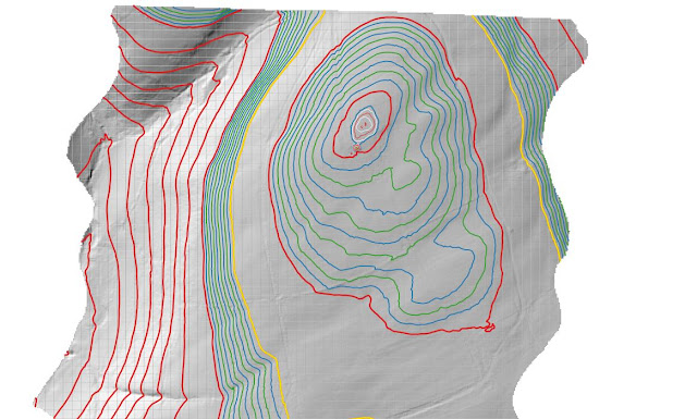%20-%20LIDAR%20summit%203.jpg) |
| LIDAR image of Pant y Fyda (SN 562 361) |
The criteria for the list that this summit
relocation applies to are:
Y Trichant
– The 300m Hills of Wales – Welsh
hills at or above 300m and below 400m in height that have 30m minimum drop, with an accompanying sub list entitled the
Sub-Trichant, with the criteria for this sub category being all Welsh hills at
or above 300m and below 400m in height with 20m or more and below 30m of
drop. The list is authored by Myrddyn Phillips with the
Introduction to the list and the renaming of it appearing on Mapping Mountains
on the 13th May 2017, and the Introduction to the Mapping Mountains
publication of the list appearing on the 1st January 2022.
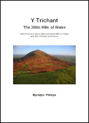 |
| Y Trichant - The 300m Hills of Wales by Myrddyn Phillips |
The name the hill is now listed by is Pant y Fyda,
and it is adjoined to the Mynydd Pencarreg group of hills, which are situated in the south-western part of
South Wales (Region B, Sub-Region B1), and
it is positioned with minor roads to its north and west, the B4310 road to its south-east
and the B4337 road to its north-east, and has the village of Llansawel towards
the east.
%20IMG_9876A%20-%201%2025000.jpg) |
| Extract from the Ordnance Survey 1:25,000 Explorer map |
However, it was not until LIDAR became available
that the details for this hill could be accurately re-assessed. The LIDAR (Light Detection & Ranging)
technique produced highly accurate height data that is now freely available for
much of England and Wales.
LIDAR analysis gives the highest ground on this
hill as 322.1m positioned at SN 56283 36132 and SN 56286 36133. However, this is a part of a raised water
tank and protocols dictate that as this is deemed a relatively recent man-made
construct such ground is discounted from the height of a hill.
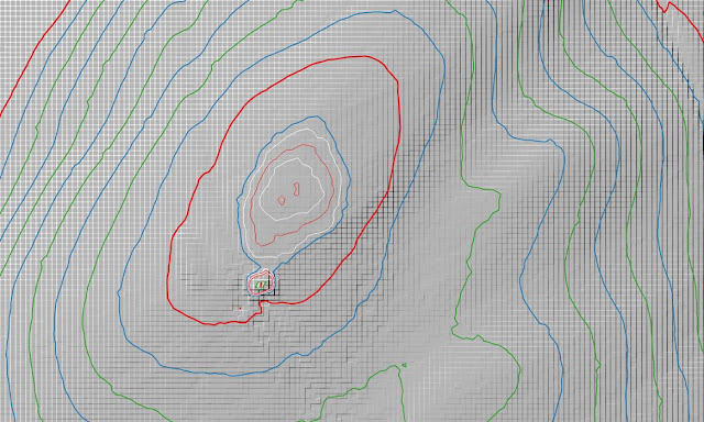%20-%20LIDAR%20summit%201.jpg) |
| LIDAR summit image of Pant y Fyda (SN 562 361) |
The height produced by LIDAR analysis to the
natural summit of this hill is 321.4m positioned at SN 56293 36166, and this
position in relation to the raised water tank comes within the parameters of
the Summit Relocations used within this page heading, these parameters are:
The term Summit Relocations applies when the high
point of the hill is found to be positioned; in a different field, to a
different feature such as in a conifer plantation, within a different map contour, to a
different point where a number of potential summit positions are within close
proximity, when natural ground or the natural and intact summit of a hill is
confirmed compared to a higher point such as a raised field boundary or covered
reservoir that is considered a relatively recent man-made construct, or a
relocation of approximately 100 metres or more in distance from either the
position of a map spot height or from where the summit of the hill was
previously thought to exist.
Therefore, the summit height produced by LIDAR
analysis is 321.4m and this is positioned at SN 56293 36166, this position is not
given a spot height on the contemporary Ordnance Survey 1:50,000 Landranger and
the 1:25,000 Explorer map, and is approximately 35 metres northward from where
the high point of the raised water tank is positioned.
The full details for the hill are:
Group: Mynydd Pencarreg
Name: Pant y Fyda
OS 1:50,000 map: 146
Summit Height: 321.4m (LIDAR)
Summit Grid Reference
(New Position): SN 56293 36166 (LIDAR)
Bwlch Height: c 287m (interpolation)
Bwlch Grid
Reference: SN 55727 36635 (interpolation)
Drop: c 34m (LIDAR summit and interpolated bwlch)
Myrddyn Phillips (August
2023)

%20-%20LIDAR%20summit%203.jpg)

%20IMG_9876A%20-%201%2025000.jpg)
%20-%20LIDAR%20summit%201.jpg)
No comments:
Post a Comment