Rhos Ymryson (SN 460 499)
There has been a Summit Relocation to a hill that
is listed in the Y Trichant – The 300m
Hills of Wales and Y Trechol – The
Dominant Hills of Wales, with the summit height, bwlch height and their
locations, the drop and status of the hill derived from LIDAR analysis
conducted by Myrddyn Phillips.
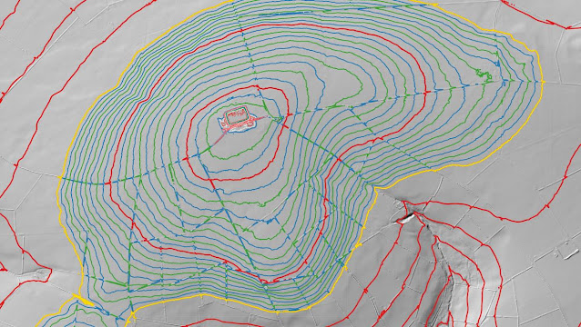%20-%20LIDAR%20summit%205.jpg) |
| LIDAR image of Rhos Ymryson (SN 460 499) |
The criteria for the two listings that this summit
relocation applies to are:
 |
| Y Trichant - The 300m Hills of Wales by Myrddyn Phillips |
 |
| Y Trechol - The Dominant Hills of Wales by Myrddyn Phillips |
The name the hill is listed by is Rhos Ymryson,
and it is adjoined to the Mynydd Bach group of hills, which are situated in the western part of South
Wales (Region B, Sub-Region B1), and
it is positioned with the B4338 road to its north-east, a minor road to its
north-west and the A475 road to its south, and has the village of Llanwenog
towards the south-east.
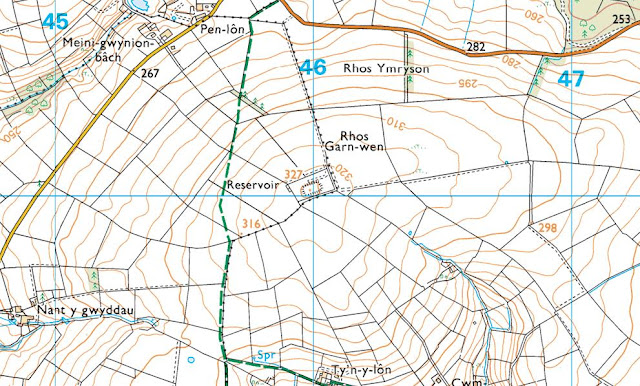%20-%201%2025000.jpg) |
| Extract from the Ordnance Survey 1:25,000 Explorer map |
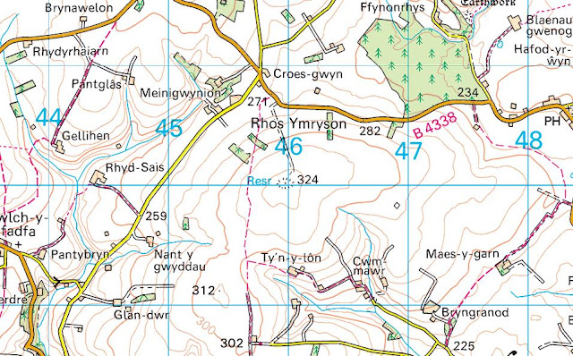%20-%201%2050000.jpg) |
| Extract from the Ordnance Survey 1:50,000 Landranger map |
When the original 300m height band of Welsh P30 hills were published on Geoff Crowder’s v-g.me website, this hill was included
in the main P30 list with a 327m summit height, based on the spot height that
appears on the contemporary Ordnance Survey 1:25,000 Explorer map and which is
positioned at SN 459 500. However, this
height is given to the top of a covered reservoir, whilst the contemporary
Ordnance Survey 1:50,000 Landranger map gives a 324m summit spot height, which
conforms with the rounded up 1062ft (323.7m) height shown on the Ordnance
Surveys series of Six-Inch maps.
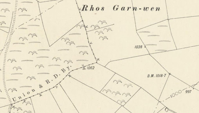%20-%20Six-Inch.jpg) |
| Extract from the Ordnance Survey series of Six-Inch maps |
However, it was not until LIDAR became available
that the details for this hill could be accurately re-assessed. The LIDAR (Light Detection & Ranging)
technique produced highly accurate height data that is now freely available for
much of England and Wales.
LIDAR analysis gives the highest ground on this
hill as 326.6m positioned at SN 45999 50009.
However, this is to the top of a covered reservoir and protocols dictate
that as this is deemed a relatively recent man-made construct such ground is
discounted from the height of a hill.
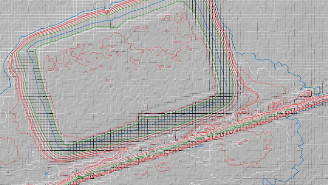%20-%20LIDAR%20summit%201.jpg) |
| LIDAR summit image of Rhos Ymryson (SN 460 499) |
The height produced by LIDAR analysis to the highest
remaining natural ground on this hill is 323.3m and is positioned at SN 46032
49996, and this position in relation to the covered reservoir comes within the parameters of
the Summit Relocations used within this page heading, these parameters are:
The term Summit Relocations applies when the high
point of the hill is found to be positioned; in a different field, to a
different feature such as in a conifer plantation, within a different map contour, to a different
point where a number of potential summit positions are within close proximity,
when natural ground or the natural and intact summit of a hill is confirmed
compared to a higher point such as a raised field boundary or covered reservoir
that is considered a relatively recent man-made construct, or a relocation of
approximately 100 metres or more in distance from either the position of a map
spot height or from where the summit of the hill was previously thought to
exist.
Therefore, the summit height produced by LIDAR
analysis is 323.3m and this is positioned at SN 46032 49996, this position is
not given a spot height on the contemporary Ordnance Survey 1:25,000 Explorer
map, but is given a 324m spot height on the contemporary 1:50,000 Landranger map,
and is approximately 33 metres east south-eastward from the high point of the covered
reservoir.
The full details for the hill are:
Group: Mynydd Bach
Name: Rhos Ymryson
OS 1:50,000 map: 146
Summit Height: 323.3m (LIDAR)
Summit Grid Reference
(New Position): SN 46032 49996 (LIDAR)
Bwlch Height: 162.6m (LIDAR)
Bwlch Grid
Reference: SN 61745 57992 (LIDAR)
Drop: 160.8m (LIDAR)
Dominance: 49.72% (LIDAR)
Myrddyn Phillips
(January 2024)

%20-%20LIDAR%20summit%205.jpg)


%20-%201%2025000.jpg)
%20-%201%2050000.jpg)
%20-%20Six-Inch.jpg)
%20-%20LIDAR%20summit%201.jpg)
No comments:
Post a Comment