
Introduction
I have approached a number of people to write articles, but if readers would like to contribute an article please contact me. The only two stipulations I make are that the article has to be hill related and that I don't end up in court through its publication! Otherwise the choice of subject matter is down to the Guest Contributor.
The Islands of Traeth Mawr
In July 1811, William Alexander Madocks, a local landowner and Member of Parliament, successfully constructed an embankment across the estuary, in a daring scheme to reclaim land and improve the connection between London and Dublin. It also allowed for the establishment of a much needed harbour for the growing slate industry at Blaenau Ffestiniog. Apart from a significant breach, which was repaired in 1814, the sea subsequently lost its dominion over Traeth Mawr. The 1824 launching of the Porthmadog vessel ‘Two Brothers’, marked the beginning of the town’s prosperous shipping period, one which would end in 1913 with the launching of the schooner ‘Gestiana’ [3, 4]. She, the last in line of hundreds of ships built at Porthmadog, was driven ashore on her maiden voyage during a storm off Cape Breton, Nova Scotia, where she “broke up and become a total wreck” [3]. A poignant end to a remarkable period.
The following list is an attempt to catalogue and highlight the delights of ‘the islands of Traeth Mawr’. Eighteen rocky hills or knolls are found on the landward side of the Cob embankment, many of which are seldom visited and have an interesting history attached to them. To qualify for listing, a 5 m height limit was chosen for the land connecting an island to the mainland, as for the simplicity of listing it provides a convenient number to work with. The compilation of this list resulted in the discovery of four new Welsh 30 m prominence hills, two of which (Ynys Berfedd and Ynys Glog) were found from analysis of the Ordnance Survey’s enlarged online mapping, whilst the other two (the twin summits of Ynys Hir) were confirmed from GPS surveys carried out by Myrddyn Phillips. All four hills have been duly promoted to appear in the latest revision of Myrddyn Phillips’s ‘30-99m Welsh Hills’ (2003).
I have approached a number of people to write articles, but if readers would like to contribute an article please contact me. The only two stipulations I make are that the article has to be hill related and that I don't end up in court through its publication! Otherwise the choice of subject matter is down to the Guest Contributor.
Guest Contributor – Aled Williams
.jpg) |
| Aled is a research scientist by profession and has a PhD in chemistry. He has over 10 years of hill-walking experience and has completed a round of the Welsh 2,000ft mountains and subsidiary tops, and is over half of the way to finishing the English equivalent. He is also interested in natural history and especially enjoys studying the arctic-alpine flora of the Welsh mountains. Aled is currently in the process of cataloguing the place names associated with the uplands of his native country. The project represents a considerable undertaking and will take many years to complete. Aled hopes that this research can be published in a series of books at some point in the future. He is also joint author of Y Pedwarau and The Fours (Europeaklist May 2013 and December 2013 respectively) and a native of Porthmadog. |
The Islands of Traeth Mawr
By Aled Williams
A little over two-hundred years ago the Afon Glaslyn flowed into its estuary at a spot close to Llyn Glas (SH 595 461), a pool that is said to have endowed the river with its name [1]. The estuary is still known as Traeth Mawr, ‘the great sands’ and one need only to gaze over the contours of a map to visualise the extent of this basin. In fact, the former water channels that riddled the saltmarsh can still be discerned from aerial photographs. At low tide the estuary provided a relatively short gateway to and from the north-western districts of Gwynedd, and as the crossing was fraught with danger, local guides could be hired for the purpose with routes commencing from Llanfrothen, Penrhyndeudraeth and Penmorfa. Those unfamiliar with the crossing risked becoming one of the “several entries in parish burial registers” [2].
 |
| Figure 1. 1850 lithograph of Porthmadog harbour by C .F. Williams, showing the expanse of Traeth Mawr in the background, with Ynys Tywyn on the right-hand side of the bridge. |
In July 1811, William Alexander Madocks, a local landowner and Member of Parliament, successfully constructed an embankment across the estuary, in a daring scheme to reclaim land and improve the connection between London and Dublin. It also allowed for the establishment of a much needed harbour for the growing slate industry at Blaenau Ffestiniog. Apart from a significant breach, which was repaired in 1814, the sea subsequently lost its dominion over Traeth Mawr. The 1824 launching of the Porthmadog vessel ‘Two Brothers’, marked the beginning of the town’s prosperous shipping period, one which would end in 1913 with the launching of the schooner ‘Gestiana’ [3, 4]. She, the last in line of hundreds of ships built at Porthmadog, was driven ashore on her maiden voyage during a storm off Cape Breton, Nova Scotia, where she “broke up and become a total wreck” [3]. A poignant end to a remarkable period.
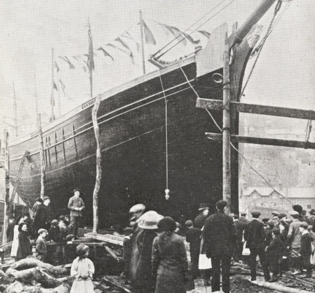 |
| Figure 2. The ‘Gestiana’ is launched in 1913. The fate of the schooner (last of the Porthmadog ships) was hinted at when the christening bottle failed to break on the bow. Photograph taken from ‘Porthmadog Ships’ by E. Hughes and A. Eames. |
The following list is an attempt to catalogue and highlight the delights of ‘the islands of Traeth Mawr’. Eighteen rocky hills or knolls are found on the landward side of the Cob embankment, many of which are seldom visited and have an interesting history attached to them. To qualify for listing, a 5 m height limit was chosen for the land connecting an island to the mainland, as for the simplicity of listing it provides a convenient number to work with. The compilation of this list resulted in the discovery of four new Welsh 30 m prominence hills, two of which (Ynys Berfedd and Ynys Glog) were found from analysis of the Ordnance Survey’s enlarged online mapping, whilst the other two (the twin summits of Ynys Hir) were confirmed from GPS surveys carried out by Myrddyn Phillips. All four hills have been duly promoted to appear in the latest revision of Myrddyn Phillips’s ‘30-99m Welsh Hills’ (2003).
Name
|
Height (m)
|
Grid Reference
|
Drop (m)
|
Hir Ynys
|
58
|
SH 605 405
|
54
|
Ynys Ferlas
|
47
|
SH 597 436
|
43
|
Ynysfor
|
45
|
SH 599 422
|
41
|
Ynys Berfedd
|
43
|
SH 599 398
|
38
|
Ynys Glog
|
42
|
SH 596 398
|
35
|
Ynys Hir – Bryn Percival
|
37
|
SH 567 397
|
34
|
Ynys Hir – Bryn y Winllan
|
37
|
SH 566 398
|
30
|
Ynys Fadog
|
28
|
SH 565 398
|
25
|
Ynys Carreg Aethnen
|
22
|
SH 573 400
|
19
|
Ynys Tywyn
|
20
|
SH 571 385
|
20
|
Bryn y Bont
|
20
|
SH 596 460
|
15
|
Ynys Galch
|
20
|
SH 568 393
|
17
|
Ynys Cerrig Duon
|
19
|
SH 572 390
|
17
|
Ynys Fach
|
18
|
SH 601 430
|
14
|
Ynys y Gwely
|
17
|
SH 597 406
|
15
|
Bryn
|
12
|
SH 569 399
|
8
|
Ynys Ceiliog
|
9
|
SH 595 402
|
6
|
Ynys Pen Syflog
|
7
|
SH 561 394
|
4
|
We will start our tour of the Traeth Mawr islands at Aberglaslyn, where the wooded knoll of Bryn y Bont, ‘bridge hill’, rises directly above the pool of Llyn Glas. To the south-west of this hill is the site of an arched bridge of some antiquity, cited as medieval on Coflein (NPRN: 413622), with the famous Pont Aberglaslyn impressively spanning the Glaslyn to the north-west. Prior to the reclamation of the estuary a number of weirs existed at Aberglaslyn. The traveller and renowned antiquarian Thomas Pennant described these as being a “salmon fishery” in 1781, and he had been informed that it was the “royal wear [sic] in the reign of Henry IV” [5]. David Jenkins writing in 1899 noted that the construction of the Cob embankment resulted in the weirs losing their worth and they were “allowed to fall into ruins” [1].
 |
| Figure 3. The view from Pont Aberglaslyn. Photograph taken by the author. |
Heading south to the next island of Ynys Ferlas, the peninsular hills of Garth (55 m – SH 601 456), Bryn y Gwynt (56 m – SH 599 448) and Bryn Tŵr (52 m – SH 605 441) project out on the eastern side of Traeth Mawr. The 13th century ‘Aberconwy Charter’, in which Llywelyn ap Iorwerth (Llywelyn Fawr) grants the Cistercian monks of Aberconwy much land, records the name of the Afon Glaslyn as “fluvium ferlas” [6]. R. J. Thomas in ‘Enwau Afonydd a Nentydd Cymru’ mentions that the river was formerly known as Fferlas or Ferlas [7], and from this evidence an appropriate translation to the name Ynys Ferlas could simply be ‘Ferlas island’. The pool in the river at SH 595 438 is known to local fishermen as Llyn Ferlas or Pwll Ferlas, and in former times a ferry boat was in operation close to the island [8], adjacent to the Turnpike Cottage/Tyrpeg Traeth at SH 592 436.
 |
| Figure 4. Bryn Tŵr with the aptly named Moelwynion in the background. Photograph taken by the author. |
Only a short distance to the south-east of Ynys Ferlas lie the ‘large’ and ‘small’ islands of Ynysfor and Ynys Fach respectively. Ynysfor is a shortening of Ynys Fawr, analogous to that of Llwytmor in the Carneddau. Several short embankments are found in this area, examples of earlier and smaller scale attempts to manipulate the natural sweep of the tide across the land. The house of Ynysfor used to be the home of a long running hunt, and a colourful history of it is given in an article by B. D. Roberts, which the following remarks are quoted from: “Ynysfor on its wooded knoll was cut off by the high tide. The land round the farm was surrounded by two lines of embankments” [8]. It is then mentioned that the tide could interfere with hunting arrangements, and as such the hounds were usually kennelled on the slopes of Moel Ddu to ensure an effective start to the following day’s hunt. In 2005, the farm of Ynysfor became important for ornithological reasons when a pair of ospreys nested and successfully fledged young nearby the island. They have continued to breed annually, returning each March from their wintering grounds in Africa. A visitor centre operates each season at Pont Croesor (SH 592 413), which provides an excellent facility for the public to view the birds on the nest.
The next group of islands flank the eastern side of Traeth Mawr and are known as Ynys y Gwely (‘island of the bed’), Ynys Ceiliog (‘cockerel island’), Ynys Glog (‘island of the cliff’), Ynys Berfedd (‘middle island’) and Hir Ynys (‘long island’), and it is interesting to note that the remarkable Edward Llwyd documented some of these names in his 1696 ‘parochial queries’: “Yr hir ynys, Ynys y Keiliog, Y Glôg [sic]”. Beneath the rocky Ynys Glog and Ynys Berfedd are deep river pools at SH 586 403 and SH 596 399, which are known to local fishermen as Llyn Hir Ynys and Llyn Glog respectively. To the south of these stands the quarried peninsular hill of Y Garth (SH 594 391), which is known locally as Ynys Gron, the ‘rounded island’. This pudding-shaped hill once reached an elevation of 323 ft (98.5 m), giving it a healthy prominence of approximately 53 m. Its rounded shape made it a conspicuous object in old photographs and drawings of the estuary. However, the quarry has sadly downgraded the height and prominence of Ynys Gron to around 65 and 20 m respectively.
 |
| Figure 5. An osprey fishing on the Afon Glaslyn. Photograph taken by Karen Williams. |
The final cluster of islands are found on the outskirts of Porthmadog and its neighbouring village of Tremadog, but before these are discussed, the small islet of Cei Balast (SH 570 380), ‘ballast quay’, is worthy of attention. As the name suggests, Cei Balast is of artificial construction and is a direct result of the Porthmadog shipping industry. It consists of ballast deposited upon a sand bank, and as such rocks of a non-local origin may be found there. The island was also known as Lewis’s Island, after the man who operated a “rail-mounted steam crane” situated on the island’s small quay, which was used to “expedite the unloading and deposition of the stone” [9].
Ynys Carreg Aethnen: The name
of this island only became known to the author from research conducted
specifically for this article, having previously only known it by the rather
informal Ynys Farm Yard. The first clue
to the name appeared in the book ‘Y Gestiana’ by A. Eifion [10], where
the name appears several times as Ynys Garreg Aethnen. However, the name is recorded in a letter
written by William Madocks to John Williams, dated the 26th of April 1828
(Archive Reference: XD/8/2/268), as Ynys Cerrig Eithin. These two versions differ in respect to
botany, as aethnen is the Welsh name
for the aspen tree, whilst eithin is
the Welsh for gorse. The current farmer
knows the land of this island as Aethnyn, but the house at SH 574 401 is named
Gwern Eithin [11]. The puzzle
was solved after studying the Tithe apportionments of the “Ynyscynhaiarn [sic]”
parish, where under the description of the lands and premises of Farm Yard the
name Ynys Carreg Aethuan appears [12].
In conclusion, the name of this island is Ynys Carreg Aethnen, ‘aspen
rock island’.
 |
| Figure 6. The wooded knoll of Ynys Fadog from Ynys Hir, with Ynys Pen Syflog and Moel y Gest in the background. Photograph taken by the author. |
Ynys Fadog: Along with its twin-topped neighbour of Ynys Hir, this island is now part of the plantation known locally as Y Nursery, which was planted to supply the Porthmadog ship-building industry with materials. The plantation is recorded in the “Ynyscynhaiarn [sic]” parish Tithe plans as Y Winllan [12]. However, Ynys Fadog had an earlier history attached to it, one of a mythic quality. It relates to the Welsh folklore of Prince Madog and his voyage to America in the twelfth century [1, 10]. Madog is believed to be the son of the successful Welsh prince Owain Gwynedd, the grandson of whom is none other than Llywelyn Fawr [13]. The story tells us that Madog built fishing vessels in order to fish the Traeth Mawr estuary. He soon developed a “a passion for the sea, with the result that he built larger ships lower down the river, in which he used to cruise in the open bay” [1]. Frustrated by the endless feuding and power struggles within Wales, he decided to sail westwards in the company of a small number of his countrymen. Having arrived at a strange land with “boundless riches”, Madog returned to Wales to encourage other people to emigrate. Three hundred men left with him, filling up ten ships. According to the legend, the place from which they sailed from has since been known as Ynys Fadog, and some local people believe that Porthmadog and Tremadog were also named in honour of Madog ab Owain Gwynedd, as opposed to William Alexander Madocks, since the island was known as Ynys Fadog prior to the arrival of Madocks [10].
Ynys Hir: The ‘long island’ of
Ynys Hir is made up of two rocky hills, which were surveyed on the 01/02/2014
by Myrddyn Phillips upon the encouragement of the author. The results show that the southern hill is
higher by approximately 40 cm, with both qualifying as Welsh P30 hills (hills
with a minimum prominence of 30 m). The northern
hill is notable for a pleasant high-level path that traverses under an
impressive and overhanging cliff, and analysis of the Tithe plans for the “Ynyscynhaiarn [sic]” parish suggest that this hill was known as Bryn y Winllan,
‘hill of the vineyard’ [12]. The
higher Ynys Hir hill is still known by some as Bryn Percival [11] and
further local information connects this name to an army officer who lived
nearby, and this is confirmed in the 4th of June, 1915, edition of the
‘Cambrian News’, where details of a Captain A. Philip Percival, of Bodawen (the
house beneath the hill), is revealed as serving in the South Wales Borderers [14]. The Percival family were quarry owners and
they contributed to the building of St. John’s church, Porthmadog [15]. Interestingly, A. Eifion records that a watch
tower once stood on this island [10].
Bryn: This small island rises behind the house of Bodawen and its name was unknown to the author until the Tithe plans for the “Ynyscynhaiarn [sic]” parish were studied, which lists the name of the enclosed land as Bryn, ‘hill’ [12]. Additionally, the field to the north is recorded as Weirglodd y Bryn, ‘meadow of the hill’.
 |
| Figure 7. The Cob Mawr and Cob Crwn embankments, terminating on the right-hand side at Ynys Tywyn. The wooded islands of Ynys Cerrig Duon (bottom left), Ynys Hir - Bryn Percival (bottom centre) and Ynys Galch (bottom right) can also be seen on the outskirts of Porthmadog. Photograph taken by Karen Williams. |
Ynys Pen Syflog: This is a small island upon which the farmhouse of Pen Syflog stands. The name Ynys Bryn Saflog [sic] was recorded by the Ordnance Survey in 1816. The word syflyd means ‘to stir’ or ‘to move’; could this be the meaning of the name, i.e. a place where the tidal waters would stir daily? If priority is given to the older form of saflog, the word would be based on the stem saf, as in safiad (‘stance’) or safle (‘position’), i.e. a place where people would wait for the tide to turn? The latter hypothesis is similar to the accepted meaning behind the nearby Pen Amser (SH 553 395), where the drovers from Pen Llŷn would wait until they were able to cross the sands [10]. Alternatively, it may derive from the word sefydlog (settled), i.e. the place on the estuary where a settlement was established. There is an excavation in the crag found at the northern tip of this island, which is recorded as “Pen y Syflog Ironstone Mine” by the Gwynedd Archaeological Trust (PRN: 21518), whilst to the south-west numerous trilobite fossils have been uncovered [16].
Ynys Galch: The ‘lime island’ is locally known by several names, although the others are more recent in conception. The first alternative is Ynys Coffa or Bryn Coffa, which relates to the war memorial erected at the south-western tip, whilst the second alternative, Ber Ynys, is an informal shortening of Ben yr Ynys, ‘top of the island’. Ynys Galch is likely to have been a landing site for the import of lime into the area, and the existence of pre-1800 lime kilns on the banks of Traeth Mawr is already known of. Ships carrying lime would discharge the cargo by mooring onto a rock known as a “carreg y ring”, which was a rock with a bolted ring fixed to it [17].
Ynys Cerrig Duon: The ‘island of black rocks’ stands on the periphery of a marsh where several pools exist. These pools were once popular among the youths of Porthmadog for swimming in the summer months, and to the knowledge of the author their names have not been recorded. The largest of these is Pwll Du, ‘the black pool’ (SH 58267 38514), followed by Pwll Sugno, ‘the sucking pool’ (SH 58188 38497), Pwll Gornel, ‘the corner pool’ (SH 58197 38477), Pwll Calon, ‘the heart pool’ (SH 58189 38462) and Pwll Lledod, ‘the flat-fish pool’ (SH 57932 38265) [11]. Pwll Calon is so called due to its heart-like shape. In a letter dated February 1806, William Madocks discusses with John Williams the creation of a bank from the “Great Sluice”, known locally as Y Dora (SH 572 856), to “Ynys Cerig Ddu [sic]” (Archive Reference: XD/8/2/5), and he also highlights the potential for quarrying stone on the island (Archive Reference: XD/8/2/4). A. Eifion documents that a large cellar existed on the island, which was “used in later years as a hide-away for smuggled goods” [10].
Last but not least is the island of Ynys Tywyn, which is today connected to the mainland by the bridge of Pont Britannia, the Cob embankment and the small, circular embankment of Cob Crwn. Ynys y Tywyn translates as ‘island of the sea-shore’, and it was at one time just that, as the region of Porthmadog to the west of the island was once a sand bank known as Y Tywyn. Emrys Hughes documents that before the harbour and embankment were built, the part of Y Tywyn where the quay now stands “sloped gently to the water’s edge and formed an ideal beach for the building of ships” [3]. The island is also known locally as Ber Ynys Dros Bont and stone was conveniently quarried here for the construction of the Cob [10]. Now owned by the National Trust, a good path climbs to the summit from Pont Britannia, which offers a great view of the mile-long embankment. This completes our journey of the Traeth Mawr islands, and it is hoped that some of the new information documented will be beneficial to others researching these interesting localities. These rocky islands offer pleasant excursions in unusual settings and provided that the usual caveats regarding access are considered, they are highly recommended to lovers of the outdoors.
References:
1. ‘Bedd Gelert: Its Facts, Fairies, and Folk-lore’. D. E. Jenkins. Portmadoc: Llewelyn Jenkins, 1899.
2. ‘The Botanists and Mountain Guides of Snowdonia’. D. Jones. Llygad Gwalch, 2nd edition, 2007.
3. ‘Porthmadog Ships’. E. Hughes, A. Eames. Gwynedd Archives Service, 1975.
4. ‘Through Mighty Seas’. H. Hughes. T. Stephenson & Sons Ltd. 2nd edition, 1975.
5. ‘Tours in Wales’. T. Pennant. London: Henry Hughes, volume II, 1781.
6. ‘The Aberconwy Charter’. C. Gresham. Archaeologia Cambrensis, 94, 2, 1939.
7. ‘Enwau Afonydd a Nentydd Cymru’. R. J. Thomas. Gwasg Prifysgol Cymru, 1938.
8. ‘The Ynysfor Hunt’. B. D. Roberts. Trafodion Anrhydeddus Gymdeithas y Cymmrodorion, 200-220, 1940.
9. ‘Ports and Harbours of Gwynedd: A Threat Related Assessment’. A. Davidson, J. Roberts. CADW Report No. 577, 2005.
10.‘The Gestiana’. A. Eifion. Translated by J. Kidd. Edited by R. Walwyn. Delfryn Publications, 2013. Originally published 1892.
11. Local information obtained by R. Williams, Porthmadog, on the 22/03/2014.
12. The London Gazette, 28275, July 30, 1909, p. 5807-5822.
13. ‘The Welsh People’. J. Rhys, D. B. Jones. London: T. Fisher Unwin, 1900.
14. ‘Cambrian News’ newspaper: 4th of June 1915.
15. http://www.tremadog.org.uk/content/29.php, accessed: 01/04/2014.
16. The Quarterly Journal of the Geological Society of London, 66, 1910.
17. ‘Immortal Sails. A Story of a Welsh Port and Some of its Sails’. H. M. Vaughan. Trafodion Anrhydeddus Gymdeithas y Cymmrodorion, 205-214, 1945.
No comments:
Post a Comment