Cwm Helyg (SO 121 460)
There has been a Summit Relocation to a hill that
is listed in the Y Trichant – The 300m
Hills of Wales, with the summit height, bwlch height and their locations,
the drop and status of the hill derived from detail produced by Joe Nuttall in his
surface analysis programme, with subsequent LIDAR analysis conducted by the
DoBIH team and independently by Myrddyn Phillips.
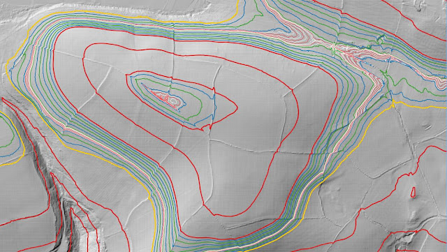%20-%20LIDAR%20hill%203.jpg) |
| LIDAR image of Cwm Helyg (SO 121 460) |
The criteria for the list that this summit
relocation applies to are:
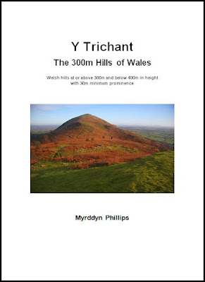 |
| Y Trichant - The 300m Hills of Wales by Myrddyn Phillips |
The name the hill is now listed by is Cwm Helyg
and this was derived from the Tithe map, and it is adjoined to the Gwaun Ceste
group of hills, which are situated in the eastern part
of South Wales (Region B, Sub-Region B3), and it is positioned with a minor road to its north and south-west, the
A470 road farther to its west and the B4594 road to its south-east, and has the
small community of Erwyd (Erwood) towards the south-west.
After the sub list was standardised, and
interpolated heights and drop values also included the details for this hill
were re-evaluated and it was listed with an estimated c 26m of drop, based on
the 332m summit spot height positioned at SO 12205 46007 and an estimated c 306m
bwlch height, based on interpolation of 10m contouring between 300m – 310m.
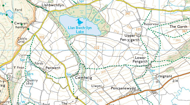%20-%201%2025000.jpg) |
| Extract from the Ordnance Survey 1:25,000 Explorer map |
However, it was not until LIDAR became available
that the details for this hill could be accurately re-assessed. The LIDAR (Light Detection & Ranging)
technique produced highly accurate height data that is now freely available for
much of England and Wales.
LIDAR analysis gives the highest ground on this
hill as 333.8m positioned at SO 12132 46026.
However, this is a part of an old raised field boundary and protocols
dictate that as this is deemed a relatively recent man-made construct such
ground is discounted from the height of a hill.
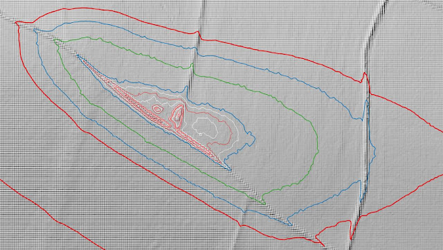%20-%20LIDAR%20summit%202.jpg) |
| LIDAR summit image of Cwm Helyg (SO 121 460) |
The height produced by LIDAR analysis to the
natural summit of this hill is 333.5m positioned at SO 12120 46030, and this
position in relation to the old raised field boundary comes within the parameters of
the Summit Relocations used within this page heading, these parameters are:
The term Summit Relocations applies when the high
point of the hill is found to be positioned; in a different field, to a
different feature such as in a conifer plantation, within a different map contour, to a
different point where a number of potential summit positions are within close
proximity, when natural ground or the natural and intact summit of a hill is
confirmed compared to a higher point such as a raised field boundary or covered
reservoir that is considered a relatively recent man-made construct, or a
relocation of approximately 100 metres or more in distance from either the
position of a map spot height or from where the summit of the hill was
previously thought to exist.
Therefore, the summit height produced by LIDAR
analysis is 333.5m and this is positioned at SO 12120 46030, this position is
not given a spot height on the contemporary Ordnance Survey 1:50,000 Landranger
and 1:25,000 Explorer map and is approximately 85 metres west north-westward
from where the 332m spot height appears and approximately 12 metres west north-westward
from the high point of the raised field boundary.
The full details for the hill are:
Group: Gwaun Ceste
Name: Cwm Helyg
OS 1:50,000 map: 148
Summit Height: 333.5m (LIDAR)
Summit Grid
Reference: SO 12120 46030 (LIDAR)
Bwlch Height: 303.8m (LIDAR)
Bwlch Grid
Reference: SO 12449 46144 (LIDAR)
Drop: 29.7m (LIDAR)
Myrddyn Phillips
(February 2024)

%20-%20LIDAR%20hill%203.jpg)

%20-%201%2025000.jpg)
%20-%20LIDAR%20summit%202.jpg)
No comments:
Post a Comment