Ffridd Cae Penfras (SJ
007 146)
There has been a
Significant Name Change to a hill that is listed in the Y Trichant – The 300m Hills of Wales, with the summit height, bwlch height and their
locations, the drop and status of the hill derived from detail on contemporary
maps produced from Ordnance Survey data.
%20-%20part%20LIDAR%20summit%202.jpg) |
| LIDAR part image of Ffridd Cae Penfras (SJ 007 146) |
The criteria for the
list that this name change applies to are:
 |
| Y Trichant - The 300m Hills of Wales by Myrddyn Phillips |
The hill is adjoined to the Esgeiriau Gwynion
group of hills, which are situated in the southern
part of North Wales (Region A, Sub-Region A3), and it is positioned with a minor road to its north
and south-west, the A458 road to its south and the B4395 road to its east, and
has the village of Llangadfan towards the south.
The hill appeared in the
original Welsh 300m P30 list on Geoff Crowder’s v-g.me website, under the
transposed name of Pren Croes, which
is a prominent name that appears to the south of the summit of this hill on the
Ordnance Survey 1:50,000 Landranger and 1:25,000 Explorer map.
During my early hill listing I paid little regard to name placement on the map, or the meaning of names and to what feature the name was appropriately applied to. Therefore, I prioritised names for listing purposes that I now understand are either inappropriate or where another name is viewed as being more appropriate.
This is not a practice that I now advocate as with time and inclination place-name data can be improved either by asking local people or by examining historic documents, through this form of research an appropriate name for the hill can usually be found.
%20IMG_0752A%20-%201%2025000.jpg) |
| Extract from the Ordnance Survey 1:25,000 Explorer map |
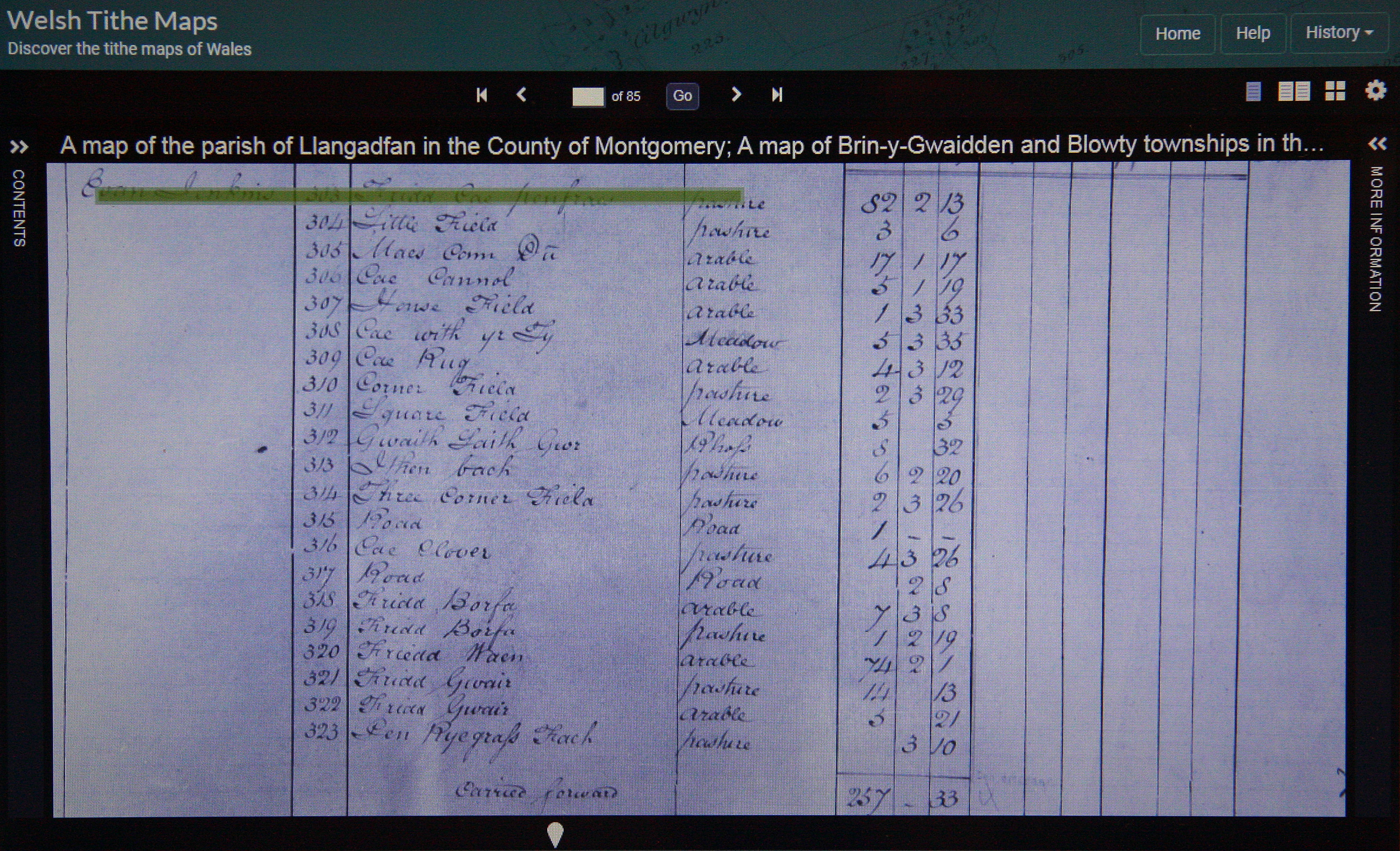
As the summit of this hill comprises bounded land
the details for it were examined on the Tithe map. The
term Tithe map is generally given to a map of a Welsh or English parish or
township and which was prepared after the 1836 Tithe Commutation Act. This act allowed tithes to be paid in cash
rather than goods. The Tithe maps gave
names of owners and occupiers of land in each parish and importantly for
place-name research they also included the name of enclosed land. This enclosed land is usually based on a
field system, however not every field is given a name, but many are and especially
so in Wales.
%20IMG_0757A%20-%20Tithe.jpg) |
| Extract from the Tithe map |
The enclosed land where the summit of this hill is
situated is given the number 303 on the Tithe map, this can be cross referenced
against the apportionments; it is these apportionments that give the name of
the owner or occupier of the land as well as the name of the land. The land where the summit of this hill is
situated is named as Ffridd Cae Penfras in the apportionments, with the details on the Tithe map appearing in the parish of Llangadfan and in the
county named as Montgomery.
 |
| Extract from the apportionments |
Therefore, the name this hill is
now listed by in the Y Trichant – The 300m
Hills of Wales is Ffridd Cae Penfras and this was derived from the Tithe map, which
substantiates its use on the contemporary Ordnance Survey 1:50,000 Landranger and 1:25,000
Explorer map.
The full details for the
hill are:
Group: Esgeiriau Gwynion
Name: Ffridd Cae Penfras
Previously Listed
Name: Pren Croes
OS 1:50,000 map: 125
Summit Height: 368m (spot height)
Summit Grid
Reference: SJ 00728 14605 (hand-held GPS
via DoBIH)
Bwlch Height: c 318m (interpolation)
Bwlch Grid
Reference: SJ 00178 14557 (interpolation)
Drop: c 50m (spot height summit and interpolated bwlch)
Myrddyn Phillips (May
2022)

%20-%20part%20LIDAR%20summit%202.jpg)

%20IMG_0752A%20-%201%2025000.jpg)
%20IMG_0757A%20-%20Tithe.jpg)
No comments:
Post a Comment