Y Trechol - The Dominant Hills of Wales - Summit Relocations
Cae Gwar Allt (SN 455 133) - 70th summit relocation
Significant Name Changes post for Cae Gwar Allt
There has been a Summit Relocation to a hill that is listed in the 100m Twmpau and Y Trechol – The Dominant Hills of Wales, with the summit height, bwlch height and their locations, the drop, dominance and status of the hill derived from LIDAR analysis conducted by Myrddyn Phillips.
%20-%20LIDAR%20hill%202.jpg) |
| LIDAR image of Cae Gwar Allt (SN 455 133) |
The criteria for the two listings that this summit relocation applies to are:
100m Twmpau - Welsh hills at or above 100m and below 200m in height that have 30m minimum drop, with an accompanying sub list entitled the 100m Sub-Twmpau, with the criteria for this sub category being all Welsh hills at or above 100m and below 200m in height with 20m or more and below 30m of drop, with the word Twmpau being an acronym standing for thirty welsh metre prominences and upward.
 |
| 100m Twmpau by Myrddyn Phillips |
 |
| Y Trechol - The Dominant Hills of Wales by Myrddyn Phillips |
The name the hill is now listed by is Cae Gwar Allt and this was derived from the Tithe map, and it is adjoined to the Mynydd Sylen group of hills, which are situated in the southern part of South Wales (Region B, Sub-Region B5), and it is positioned with minor roads to its north, west and south-east, and has the A4306 road farther to its north-east and the A4309 road to its south-west, and has the town of Caerfyrddin (Carmarthen) towards the north-west.
After the sub list was standardised, and interpolated heights and drop values also included the details for this hill were re-assessed and it was listed with an estimated c 44m of drop, based on the 111m summit spot height and an estimated c 67m bwlch height, based on interpolation of 5m contouring between 65m – 70m. With these values giving this hill 39.64% dominance.
%20-%201%2025000.jpg) |
| Extract from the Ordnance Survey 1:25,000 Explorer map |
However, it was not until LIDAR became available that the details for this hill could be accurately re-assessed. The LIDAR (Light Detection & Ranging) technique produced highly accurate height data that is now freely available for much of England and Wales.
LIDAR analysis gives the highest ground on this hill as 109.8m positioned at SN 45495 13312. However, this is probably excavated ground from construction of a pool and protocols dictate that as this is deemed a relatively recent man-made construct such ground is discounted from the height of a hill.
%20-%20LIDAR%20summit%202.jpg) |
| LIDAR summit image of Cae Gwar Allt (SN 455 133) |
The height produced by LIDAR analysis to the natural summit of this hill is 109.7m and is positioned at SN 45512 13322, and this comes within the parameters of the Summit Relocations used within this page heading, these parameters are:
The term Summit Relocations applies when the high point of the hill is found to be positioned; in a different field, to a different feature such as in a conifer plantation, within a different map contour, to a different point where a number of potential summit positions are within close proximity, when natural ground or the natural and intact summit of a hill is confirmed compared to a higher point such as a raised field boundary or covered reservoir that is judged to be a relatively recent man-made construct, or a relocation of approximately 100 metres or more in distance from either the position of a map spot height or from where the summit of the hill was previously thought to exist.
Therefore, the height produced by LIDAR analysis to the natural summit of this hill is 109.7m and is positioned at SN 45512 13322, this position is relatively close to where the spot height appears on the contemporary Ordnance Survey 1:25,000 Explorer map, and is approximately 17 metres north-eastward from the high point of the excavated ground.
The full details for the hill are:
Group: Mynydd Sylen
Name: Cae Gwar Allt
OS 1:50,000 map: 159
Summit Height: 109.7m (LIDAR)
Summit Grid Reference (New Position): SN 45512 13322 (LIDAR)
Bwlch Height: 67.5m (LIDAR)
Bwlch Grid Reference: SN 46302 13388 (LIDAR)
Drop: 42.2m (LIDAR)
Dominance: 38.46% (LIDAR)
Myrddyn Phillips (July 2024)
Y Trechol - The Dominant Hills of Wales - Summit Relocations
Safle Claddu Nant y Caws (SN 468 174) & (SN 469 174) and Cae Mawr (SN 462 175) - 69th summit relocation
Hill Reclassifications post for Safle Claddu Nant y Caws and Cae Mawr
Significant Height Revisions post for Safle Claddu Nant y Caws and Cae Mawr
There has been confirmation of a Summit Relocation to a hill that is now listed as a Dual Summit in the 100m Twmpau and Y Trechol – The Dominant Hills of Wales, with the summit height, bwlch height and their locations, the drop, dominance and status of the hill derived from LIDAR analysis conducted by Myrddyn Phillips.
%20-%20LIDAR%20hill%202.jpg) |
| LIDAR image of Cae Mawr (SN 462 175) and Safle Claddu Nant y Caws (SN 468 174) & (SN 469 174) |
The criteria for the two listings that this summit relocation applies to are:
100m Twmpau - Welsh hills at or above 100m and below 200m in height that have 30m minimum drop, with an accompanying sub list entitled the 100m Sub-Twmpau, with the criteria for this sub category being all Welsh hills at or above 100m and below 200m in height with 20m or more and below 30m of drop, with the word Twmpau being an acronym standing for thirty welsh metre prominences and upward.
 |
| 100m Twmpau by Myrddyn Phillips |
 |
| Y Trechol - The Dominant Hills of Wales by Myrddyn Phillips |
Dual Summit hills:A hill classified as a Dual Summit is defined as one which has an extant natural summit coupled with that of a higher artificial summit, with the latter that can be described as stable in character. In the main, these recent man-made constructions are the result of quarrying activities producing spoil tips, or as in this instance a landfill. These recent man-made constructions are treated differently to ancient man-made constructions such as hill forts and tumuli, as if the latter are deemed stable and of an earthen character their age dictates that they can be viewed as being permanent in nature and are now effectively a part of the hill. For those bagging Dual Summit hills, a visit to either the natural high point or the elevated man-made high point is sufficient to claim an ascent of the hill. With the Dual Summit classification being a relatively new category and fist instigated in January 2018 for a Dual Summit Pedwar.
The name the hill is now listed by is Safle Claddu Nant y Caws for the higher man-made summit and Cae Mawr for the lower natural summit, and it is adjoined to the Mynydd Sylen group of hills, which are situated in the southern part of South Wales (Region B, Sub-Region B5), and the two summits are positioned with the A48 road to their north and a minor road to their south-west, and has the town of Caerfyrddin (Carmarthen) towards the north-west.
When the original 100m height band of Welsh P30 hills were published on Geoff Crowder’s v-g.me website, the natural summit was included in the main P30 list with a 155m summit height, based on the spot height adjoined to a triangulation pillar positioned at SN 46405 17608 that appears on the contemporary Ordnance Survey 1:50,000 Landranger and 1:25,000 Explorer map.
%20-%201%2025000.jpg) |
| Extract from the Ordnance Survey 1:25,000 Explorer map |
After the sub list was standardised, and interpolated heights and drop values also included the details for this hill were re-evaluated and it was then separated in to its two component parts, with the man-made summit listed with an estimated c 59m of drop, based on an estimated c 156m summit height positioned at SN 46909 17343 and an estimated c 97m bwlch height, with both heights based on interpolation of 5m contouring that appeared on the interactive mapping hosted on the OS Maps website. With the lower natural summit listed with a 155 summit height and the bwlch between these two summits estimated as c 138m, which if separating these hills would give an estimated c 17m of drop.
However, it was not until LIDAR became available that the details for these summits could be accurately re-assessed. The LIDAR (Light Detection & Ranging) technique produced highly accurate height data that is now freely available for much of England and Wales.
%20-%20LIDAR%20summit%206%20x%202.jpg) |
| LIDAR summit image of Cae Mawr (SN 462 175) and Safle Claddu Nant y Caws (SN 468 174) & (SN 469 174) |
LIDAR analysis gives the highest ground at the man-made summit as 163.8m positioned at SN 46899 17416 & SN 46900 17411, and this compared to the originally listed summit which LIDAR gives as 155.1m positioned at SN 46268 17566 comes within the parameters of the Summit Relocations used within this page heading, these parameters are:
The term Summit Relocations applies when the high point of the hill is found to be positioned; in a different field, to a different feature such as in a conifer plantation, within a different map contour, to a different point where a number of potential summit positions are within close proximity, when natural ground or the natural and intact summit of a hill is confirmed compared to a higher point such as a raised field boundary or covered reservoir that is judged to be a relatively recent man-made construct, or a relocation of approximately 100 metres or more in distance from either the position of a map spot height or from where the summit of the hill was previously thought to exist.
Therefore, the height produced by LIDAR analysis to the higher of the two Dual Summits is 163.8m and is positioned at SN 46899 17416 & SN 46900 17411, and this for listing purposes is the prioritised summit and it is not given a spot height on the contemporary Ordnance Survey 1:50,000 Landranger and 1:25,000 Explorer map, and is approximately 630 metres east south-eastward from where the originally listed summit is positioned.
The full details for the hill are:
Group: Mynydd Sylen
Name: Safle Claddu Nant y Caws (artificial Dual Summit) and Cae Mawr (natural Dual Summit)
OS 1:50,000 map: 159
Summit Height: 163.8m (artificial Dual Summit) and 155.1m (natural Dual Summit) (LIDAR)
Summit Grid Reference (New Position): SN 46899 17416 & SN 46900 17411 (artificial Dual Summit) and SN 46268 17566 (natural Dual Summit) (LIDAR)
Bwlch Height: 98.5m (LIDAR)
Bwlch Grid Reference: SN 39491 11374 & SN 39493 11375 (LIDAR)
Drop: 65.3m (artificial Dual Summit) and 56.6m (natural Dual Summit) (LIDAR)
Dominance: 39.89% (artificial Dual Summit) and 36.50% (natural Dual Summit) (LIDAR)
Myrddyn Phillips (July 2024)
Y Trechol - The Dominant Hills of Wales - Summit Relocations
DUE TO
SUBSEQUENT LIDAR ANALYSIS THE SUMMIT POSITION OF THIS HILL HAS BEEN RELOCATED
TO SM 72972 04697
The Head (SM 731 046) - 68th summit relocation
There has been a Summit Relocation to a hill that is listed in the 30-99m Twmpau, Y Trechol – The Dominant Hills of Wales and Y Pellennig – The Remotest Hills of Wales, with the summit height and its location, the drop, dominance, remoteness and status of the hill prompted by detail produced by Joe Nuttall in his surface analysis programme (JNSA).
The criteria for the three listings that this summit relocation applies to are:
30-99m Twmpau - Welsh hills at or above 30m and below 100m in height that have 30m minimum drop, with an accompanying sub list entitled the 30-99m Sub-Twmpau, with the criteria for this sub category being all Welsh hills at or above 30m and below 100m in height with 20m or more and below 30m of drop, with the word Twmpau being an acronym standing for thirty welsh metre prominences and upward.
 |
| 30-99m Twmpau by Myrddyn Phillips |
 |
| Y Trechol - The Dominant Hills of Wales by Myrddyn Phillips |
 |
| Y Pellennig - The Remotest Hills of Wales by Myrddyn Phillips and Aled Williams |
The name the hill is listed by is The Head, and it is adjoined to the Garn Fawr group of hills which are situated in the south-western part of South Wales (Region B, Sub-Region B1), and it is positioned on the island of Skokholm which is positioned to the south-west of the Pembrokeshire coast.
When the original 30-99m height band of Welsh P30 hills were published on Geoff Crowder’s v-g.me website, this hill was included in the main P30 list with a 55m summit height positioned at SM 730 047, with an accompanying note stating; Height from 1:10000 map, details from David Purchase.
After the sub list was standardised, and interpolated heights and drop values also included the details for this hill were re-evaluated and it was listed with an estimated c 56m summit height and drop, based on interpolation of its largest 55m uppermost contour positioned at SM 72969 04698. The summit position was subsequently and slightly amended to SM 72970 04701 from detail that appeared on the Hill Bagging website.
%20-%201%2025000.jpg) |
| Extract from the Ordnance Survey 1:25,000 Explorer map |
However, it was not until Joe Nuttall developed his surface analysis programme that the details of this hill could be analysed via the OS Terrain product. The height produced by the surface analysis programme is 55.0m and this is positioned at SM 73112 04672, and this comes within the parameters of the Summit Relocations used within this page heading, these parameters are:
The term Summit Relocations applies when the high point of the hill is found to be positioned; in a different field, to a different feature such as in a conifer plantation, within a different map contour, to a different point where a number of potential summit positions are within close proximity, when natural ground or the natural and intact summit of a hill is confirmed compared to a higher point such as a raised field boundary or covered reservoir that is judged to be a relatively recent man-made construct, or a relocation of approximately 100 metres or more in distance from either the position of a map spot height or from where the summit of the hill was previously thought to exist.
Therefore, the height produced by the surface analysis programme developed by Joe Nuttall is 55.0m and is positioned at SM 73112 04672, this position is not given a spot height on the contemporary Ordnance Survey 1:50,000 Landranger and 1:25,000 Explorer map, and is positioned to a different 55m contour and approximately 42 metres eastward from where the previously listed summit is positioned.
The full details for the hill are:
Group: Garn Fawr
Name: The Head
OS 1:50,000 map: 157
Summit Height: 55.0m (JNSA)
Summit Grid Reference (New Position): SM 73112 04672 (JNSA)
Bwlch Height: N/A (island)
Bwlch Grid Reference: N/A (island)
Drop: 55.0m (JNSA)
Dominance: 100.00% (island)
Remoteness: 5.21km (JNSA)
Myrddyn Phillips (May 2024)
Y Trechol - The Dominant Hills of Wales - Summit Relocations
Cefn y Coed (SH 667 172) - 67th summit relocation
Significant Height Revisions post for Cefn y Coed
Significant Name Changes post for Cefn y Coed
There has been a Summit Relocation to a hill that is listed in the 30-99m Twmpau and Y Trechol – The Dominant Hills of Wales, with the summit height, bwlch height and their locations, the drop, dominance and status of the hill derived from LIDAR analysis conducted by Myrddyn Phillips.
%20-%20LIDAR%20hill%201.jpg) |
| LIDAR image of Cefn y Coed (SH 667 172) |
The criteria for the two listings that this summit relocation applies to are:
30-99m Twmpau - Welsh hills at or above 30m and below 100m in height that have 30m minimum drop, with an accompanying sub list entitled the 30-99m Sub-Twmpau, with the criteria for this sub category being all Welsh hills at or above 30m and below 100m in height with 20m or more and below 30m of drop, with the word Twmpau being an acronym standing for thirty welsh metre prominences and upward.
 |
| 30-99m Twmpau by Myrddyn Phillips |
 |
| Y Trechol - The Dominant Hills of Wales by Myrddyn Phillips |
The name the hill is now listed by is Cefn y Coed and this was derived from the Tithe map, and it is adjoined to the Cadair Idris group of hills, which are situated in the south-western part of North Wales (Region A, Sub-Region A3), and it is positioned with the A493 road to its south-east, and has the town of Dolgellau towards the east.
%20-%201%2025000.jpg) |
| Extract from the Ordnance Survey 1:25,000 Explorer map |
When the sub list was standardised, and interpolated heights and drop values also included the details for this hill were re-evaluated and it was listed with an estimated c 64m of drop, based on an estimated c 91m summit height positioned at SH 66668 17206 and an estimated c 27m bwlch height, based on interpolation of 10m contouring between 20m – 30m, with these values giving this hill 70.33% dominance.
However, it was not until LIDAR became available that the details for this hill could be accurately re-assessed. The LIDAR (Light Detection & Ranging) technique produced highly accurate height data that is now freely available for much of England and Wales.
LIDAR analysis gives the highest ground on this hill as 89.0m positioned at SH 66751 17241, and this comes within the parameters of the Summit Relocations used within this page heading, these parameters are:
The term Summit Relocations applies when the high point of the hill is found to be positioned; in a different field, to a different feature such as in a conifer plantation, within a different map contour, to a different point where a number of potential summit positions are within close proximity, when natural ground or the natural and intact summit of a hill is confirmed compared to a higher point such as a raised field boundary or covered reservoir that is judged to be a relatively recent man-made construct, or a relocation of approximately 100 metres or more in distance from either the position of a map spot height or from where the summit of the hill was previously thought to exist.
Therefore, the height produced by LIDAR analysis to the highest ground on this hill is 89.0m and is positioned at SH 66751 17241, this position is not given a spot height on the contemporary Ordnance Survey 1:50,000 Landranger and 1:25,000 Explorer map, and is approximately 83 metres north-eastward and placed in a different map contour compared to where the previously listed summit is positioned.
The full details for the hill are:
Group: Cadair Idris
Name: Cefn y Coed
OS 1:50,000 map: 124
Summit Height: 89.0m (LIDAR)
Summit Grid Reference (New Position): SH 66751 17241 (LIDAR)
Bwlch Height: 26.7m (LIDAR)
Bwlch Grid Reference: SH 67045 17182 (LIDAR)
Drop: 62.3m (LIDAR)
Dominance: 69.98% (LIDAR)
Myrddyn Phillips (May 2024)
Y Trechol - The Dominant Hills of Wales - Summit Relocations
Coed Gaer (SH 799 808) - 66th summit relocation
Survey post for Coed Gaer
Significant Name Changes post for Coed Gaer
There has been a Summit Relocation to a hill that is listed in the 100m Twmpau and Y Trechol – The Dominant Hills of Wales, with the summit height, bwlch height and their locations, the drop, dominance and status of the hill derived from a Trimble GeoXH 6000 summit survey and LIDAR bwlch analysis conducted by Myrddyn Phillips.
.JPG) |
| Coed Gaer (SH 799 808) |
The criteria for the two listings that this summit relocation applies to are:
100m Twmpau - Welsh hills at or above 100m and below 200m in height that have 30m minimum drop, with an accompanying sub list entitled the 100m Sub-Twmpau, with the criteria for this sub category being all Welsh hills at or above 100m and below 200m in height with 20m or more and below 30m of drop, with the word Twmpau being an acronym standing for thirty welsh metre prominences and upward.
 |
| 100m Twmpau by Myrddyn Phillips |
 |
| Y Trechol - The Dominant Hills of Wales by Myrddyn Phillips |
The name the hill is listed by is Coed Gaer, and it is adjoined to the Mynydd Hiraethog group of hills, which are situated in the northern part of North Wales (Region A, Sub-Region A2), and it is positioned with the B5115 road to its north, the A470 road to its west and minor roads to its south and east, and has the town of Llandudno towards the north-west.
%20-%201%2025000.jpg) |
| Extract from the Ordnance Survey 1:25,000 Explorer map |
.JPG) |
| The Trimble GeoXH 6000 gathering data at the summit of Coed Gaer |
However, it was not until the survey with the Trimble GeoXH 6000 that an accurate height could be ascertained for one of these points and not until LIDAR became available that the details for these two points could be re-assessed. The LIDAR (Light Detection & Ranging) technique produced highly accurate height data that is now freely available for much of England and Wales.
%20-%20LIDAR%20summit%202.jpg) |
| LIDAR summit image of Coed Gaer (SH 799 808) |
LIDAR analysis gives the highest ground close to the old prioritised summit as 131.1m positioned at SH 80216 80952, whilst the survey with the Trimble GeoXH 6000 gives the height of the recognised summit as 134.0m positioned at SH 79924 80840, and when compared to the original prioritised summit position this comes within the parameters of the Summit Relocations used within this page heading, these parameters are:
The term Summit Relocations applies when the high point of the hill is found to be positioned; in a different field, to a different feature such as in a conifer plantation, within a different map contour, to a different point where a number of potential summit positions are within close proximity, when natural ground or the natural and intact summit of a hill is confirmed compared to a higher point such as a raised field boundary or covered reservoir that is judged to be a relatively recent man-made construct, or a relocation of approximately 100 metres or more in distance from either the position of a map spot height or from where the summit of the hill was previously thought to exist.
Therefore, the height produced by the Trimble GeoXH 6000 survey to the recognised summit is 134.0m and is positioned at SH 79924 80840, this position is given an uppermost 130m ring contour on the contemporary Ordnance Survey 1:25,000 Explorer map, and is approximately 290 metres south-westward from the position of the old prioritised summit.
The full details for the hill are:
Group: Mynydd Hiraethog
Name: Coed Gaer
OS 1:50,000 map: 115
Summit Height: 134.0m (converted to OSGM15, Trimble GeoXH 6000)
Summit Grid Reference (New Position): SH 79924 80840 (Trimble GeoXH 6000)
Bwlch Height: 60.0m (LIDAR)
Bwlch Grid Reference: SH 81486 81889 (LIDAR)
Drop: 74.0m (Trimble GeoXH 6000 summit and LIDAR bwlch)
Dominance: 55.25% (Trimble GeoXH 6000 summit and LIDAR bwlch)
Myrddyn Phillips (April 2024)
Y Trechol - The Dominant Hills of Wales - Summit Relocations
Bryn Pydew (SH 810 789) - 65th summit relocation
There has been a Summit Relocation to a hill that is listed in the 100m Twmpau and Y Trechol – The Dominant Hills of Wales, with the summit height, bwlch height and their locations, the drop, dominance and status of the hill derived from LIDAR analysis conducted by Myrddyn Phillips.
%20-%20LIDAR%20hill%202.jpg) |
| LIDAR image of Bryn Pydew (SH 810 789) |
The criteria for the two listings that this summit relocation applies to are:
100m Twmpau - Welsh hills at or above 100m and below 200m in height that have 30m minimum drop, with an accompanying sub list entitled the 100m Sub-Twmpau, with the criteria for this sub category being all Welsh hills at or above 100m and below 200m in height with 20m or more and below 30m of drop, with the word Twmpau being an acronym standing for thirty welsh metre prominences and upward.
 |
| 100m Twmpau by Myrddyn Phillips |
 |
| Y Trechol - The Dominant Hills of Wales by Myrddyn Phillips |
The name the hill is listed by is Bryn Pydew, and it is adjoined to the Mynydd Hiraethog group of hills, which are situated in the northern part of North Wales (Region A, Sub-Region A2), and it is positioned with the A470 road to its west, a minor road to its immediate south and the A55 road to its south-east, and has the town of Llandudno towards the north-west.
%20-%201%2025000.jpg) |
| Extract from the Ordnance Survey 1:25,000 Explorer map |
%20-%201%2050000.jpg) |
| Extract from the Ordnance Survey 1:50,000 Landranger map |
However, it was not until LIDAR became available that the details for this hill could be accurately re-assessed. The LIDAR (Light Detection & Ranging) technique produced highly accurate height data that is now freely available for much of England and Wales.
LIDAR analysis gives the highest ground on this hill as 130.0m positioned at SH 81103 78989. However, this is to the top of a covered reservoir and protocols dictate that as this is deemed a relatively recent man-made construct such ground is discounted from the height of a hill.
%20-%20LIDAR%20summit%201.jpg) |
| LIDAR summit image of Bryn Pydew (SH 810 789) |
The height produced by LIDAR analysis to the natural summit of this hill is 128.5m and is positioned at SH 81097 78986, and this comes within the parameters of the Summit Relocations used within this page heading, these parameters are:
The term Summit Relocations applies when the high point of the hill is found to be positioned; in a different field, to a different feature such as in a conifer plantation, within a different map contour, to a different point where a number of potential summit positions are within close proximity, when natural ground or the natural and intact summit of a hill is confirmed compared to a higher point such as a raised field boundary or covered reservoir that is judged to be a relatively recent man-made construct, or a relocation of approximately 100 metres or more in distance from either the position of a map spot height or from where the summit of the hill was previously thought to exist.
Therefore, the height produced by LIDAR analysis to the natural summit of this hill is 128.5m and is positioned at SH 81097 78986, this position is relatively close to where the spot height appears on the contemporary Ordnance Survey 1:50,000 Landranger map, and is approximately 6 metres south-westward from the high point of the covered reservoir.
The full details for the hill are:
Group: Mynydd Hiraethog
Name: Bryn Pydew
OS 1:50,000 map: 116
Summit Height: 128.5m (LIDAR)
Summit Grid Reference (New Position): SH 81097 78986 (LIDAR)
Bwlch Height: 13.15m (LIDAR)
Bwlch Grid Reference: SH 80308 80155 (LIDAR)
Drop: 115.4m (LIDAR)
Dominance: 89.77% (LIDAR)
Myrddyn Phillips (April 2024)
Y Trechol - The Dominant Hills of Wales - Summit Relocations
Hill Park (SM 955 102) - 64th summit reclocation
Hill Reclassifications post for Hill Park
Significant Name Changes post for Hill Park
There has been a Summit Relocation to a hill that is listed in the 30-99m Twmpau and Y Trechol – The Dominant Hills of Wales, with the summit height, bwlch height and their locations, the drop, dominance and status of the hill prompted by detail produced by Joe Nuttall in his surface analysis programme, with subsequent LIDAR analysis conducted by the DoBIH team and independently by Myrddyn Phillips.
%20-%20LIDAR%20hill%202.jpg) |
| LIDAR image of Hill Park (SM 955 102) |
The criteria for the two listings that this summit relocation applies to are:
30-99m Twmpau - Welsh hills at or above 30m and below 100m in height that have 30m minimum drop, with an accompanying sub list entitled the 30-99m Sub-Twmpau, with the criteria for this sub category being all Welsh hills at or above 30m and below 100m in height with 20m or more and below 30m of drop, with the word Twmpau being an acronym standing for thirty welsh metre prominences and upward.
 |
| The 30-99m Twmpau by Myrddyn Phillips |
 |
| Y Trechol - The Dominant Hills of Wales by Myrddyn Phillips |
The name the hill is now listed by is Hill Park, and this was derived from the Tithe map, and it is adjoined to the Garn Fawr group of hills which are situated in the south-western part of South Wales (Region B, Sub-Region B1), and it is positioned encircled by minor roads, with the A4076 road farther to its west, and the A477 road to its south-west, and has the village of Johnston towards the west.
After the sub list was standardised, and interpolated heights and drop values also included the details for this hill were re-evaluated and it was listed with an estimated c 31m of drop, based on the 99m summit spot height and an estimated c 68m bwlch height, based on interpolation of 5m contouring between 65m – 70m, resulting with the drop value being insufficient in relation to the summit height for consideration to Lesser Dominant status.
%20-%201%2025000.jpg) |
| Extract from the Ordnance Survey 1:25,000 Explorer map |
However, it was not until LIDAR became available that the details for this hill could be accurately re-assessed. The LIDAR (Light Detection & Ranging) technique produced highly accurate height data that is now freely available for much of England and Wales.
LIDAR analysis gives the highest ground on this hill as 101.7m positioned at SM 95588 10281. However, LIDAR contouring indicates this is a mound constituting disturbed ground, implying that it is not natural and protocols dictate that as this is deemed a relatively recent man-made construct such ground is discounted from the height of a hill.
%20-%20LIDAR%20summit%203.jpg) |
| LIDAR summit image of Hill Park (SM 955 102) |
The height produced by LIDAR analysis to the highest remaining natural ground on this hill is 99.5m and this is positioned at SM 95585 10244, and this comes within the parameters of the Summit Relocations used within this page heading, these parameters are:
The term Summit Relocations applies when the high point of the hill is found to be positioned; in a different field, to a different feature such as in a conifer plantation, within a different map contour, to a different point where a number of potential summit positions are within close proximity, when natural ground or the natural and intact summit of a hill is confirmed compared to a higher point such as a raised field boundary or covered reservoir that is judged to be a relatively recent man-made construct, or a relocation of approximately 100 metres or more in distance from either the position of a map spot height or from where the summit of the hill was previously thought to exist.
Therefore, the height produced by LIDAR analysis to the highest remaining natural ground on this hill is 99.5m and is positioned at SM 95585 10244, this position is close to where the 99m spot height appears on the contemporary Ordnance Survey 1:25,000 Explorer map, and is approximately 37 metres southward from where the mound is positioned.
The full details for the hill are:
Group: Garn Fawr
Name: Hill Park
OS 1:50,000 map: 157, 158
Summit Height: 99.5m (LIDAR)
Summit Grid Reference (New Position): SM 95585 10244 (LIDAR)
Bwlch Height: 63.6m (LIDAR)
Bwlch Grid Reference: SM 93281 10622 (LIDAR)
Drop: 35.9m (LIDAR)
Dominance: 36.16% (LIDAR)
Myrddyn Phillips (January 2024)
Y Trechol - The Dominant Hills of Wales - Summit Relocations
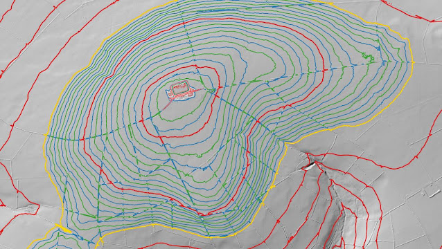
Rhos Ymryson (SN 460 499) - 63rd summit relocation
Significant Height Revisions post for Rhos Ymryson
There has been a Summit Relocation to a hill that is listed in the Y Trichant – The 300m Hills of Wales and Y Trechol – The Dominant Hills of Wales, with the summit height, bwlch height and their locations, the drop and status of the hill derived from LIDAR analysis conducted by Myrddyn Phillips.
%20-%20LIDAR%20summit%205.jpg) |
| LIDAR image of Rhos Ymryson (SN 460 499) |
The criteria for the two listings that this summit relocation applies to are:
 |
| Y Trichant - The 300m Hills of Wales by Myrddyn Phillips |
 |
| Y Trechol - The Dominant Hills of Wales by Myrddyn Phillips |
The name the hill is listed by is Rhos Ymryson, and it is adjoined to the Mynydd Bach group of hills, which are situated in the western part of South Wales (Region B, Sub-Region B1), and it is positioned with the B4338 road to its north-east, a minor road to its north-west and the A475 road to its south, and has the village of Llanwenog towards the south-east.
%20-%201%2025000.jpg) |
| Extract from the Ordnance Survey 1:25,000 Explorer map |
%20-%201%2050000.jpg) |
| Extract from the Ordnance Survey 1:50,000 Landranger map |
When the original 300m height band of Welsh P30 hills were published on Geoff Crowder’s v-g.me website, this hill was included in the main P30 list with a 327m summit height, based on the spot height that appears on the contemporary Ordnance Survey 1:25,000 Explorer map and which is positioned at SN 459 500. However, this height is given to the top of a covered reservoir, whilst the contemporary Ordnance Survey 1:50,000 Landranger map gives a 324m summit spot height, which conforms with the rounded up 1062ft (323.7m) height shown on the Ordnance Surveys series of Six-Inch maps.
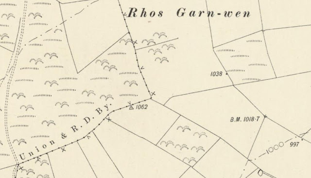%20-%20Six-Inch.jpg) |
| Extract from the Ordnance Survey series of Six-Inch maps |
However, it was not until LIDAR became available that the details for this hill could be accurately re-assessed. The LIDAR (Light Detection & Ranging) technique produced highly accurate height data that is now freely available for much of England and Wales.
LIDAR analysis gives the highest ground on this hill as 326.6m positioned at SN 45999 50009. However, this is to the top of a covered reservoir and protocols dictate that as this is deemed a relatively recent man-made construct such ground is discounted from the height of a hill.
%20-%20LIDAR%20summit%201.jpg) |
| LIDAR summit image of Rhos Ymryson (SN 460 499) |
The height produced by LIDAR analysis to the highest remaining natural ground on this hill is 323.3m and is positioned at SN 46032 49996, and this position in relation to the covered reservoir comes within the parameters of the Summit Relocations used within this page heading, these parameters are:
The term Summit Relocations applies when the high point of the hill is found to be positioned; in a different field, to a different feature such as in a conifer plantation, within a different map contour, to a different point where a number of potential summit positions are within close proximity, when natural ground or the natural and intact summit of a hill is confirmed compared to a higher point such as a raised field boundary or covered reservoir that is considered a relatively recent man-made construct, or a relocation of approximately 100 metres or more in distance from either the position of a map spot height or from where the summit of the hill was previously thought to exist.
Therefore, the summit height produced by LIDAR analysis is 323.3m and this is positioned at SN 46032 49996, this position is not given a spot height on the contemporary Ordnance Survey 1:25,000 Explorer map, but is given a 324m spot height on the contemporary 1:50,000 Landranger map, and is approximately 33 metres east south-eastward from the high point of the covered reservoir.
The full details for the hill are:
Group: Mynydd Bach
Name: Rhos Ymryson
OS 1:50,000 map: 146
Summit Height: 323.3m (LIDAR)
Summit Grid Reference (New Position): SN 46032 49996 (LIDAR)
Bwlch Height: 162.6m (LIDAR)
Bwlch Grid Reference: SN 61745 57992 (LIDAR)
Drop: 160.8m (LIDAR)
Dominance: 49.72% (LIDAR)
Myrddyn Phillips (January 2024)
Y Trechol - The Dominant Hills of Wales - Summit Relocations
Field (SN 068 063) - 62nd summit relocation
Significant Name Changes post for Field
There has been a Summit Relocation to a hill that is listed in the 30-99m Twmpau and Y Trechol – The Dominant Hills of Wales, with the summit height, bwlch height and their locations, the drop, dominance and status of the hill derived from detail produced by Joe Nuttall in his surface analysis progamme, with subsequent LIDAR analysis conducted by the DoBIH team and independently by Myrddyn Phillips.
%20-%20LIDAR%20hill%202.jpg) |
| LIDAR image of Field (SN 068 063) |
The criteria for the two listings that this summit relocation applies to are:
30-99m Twmpau - Welsh hills at or above 30m and below 100m in height that have 30m minimum drop, with an accompanying sub list entitled the 30-99m Sub-Twmpau, with the criteria for this sub category being all Welsh hills at or above 30m and below 100m in height with 20m or more and below 30m of drop, with the word Twmpau being an acronym standing for thirty welsh metre prominences and upward.
 |
| The 30-99m Twmpau by Myrddyn Phillips |
 |
| Y Trechol - The Dominant Hills of Wales by Myrddyn Phillips |
The name the hill is now listed by is Field and this was derived from the Tithe map, and it is adjoined to the Mynydd Preseli group of hills, which are situated in the south-western part of South Wales (Region B, Sub-Region B1), and it is positioned with a minor road to its immediate north and the A4075 road to its west, and has the small community of Creseli (Cresselly) towards the west.
%20-%201%2025000.jpg) |
| Extract from the Ordnance Survey 1:25,000 Explorer map |
When the sub list was standardised, and interpolated heights and drop values also included the details for this hill were re-evaluated and it was listed with an estimated c 91m summit height positioned at SN 06775 06382.
However, it was not until LIDAR became available that the details for this hill could be accurately re-assessed. The LIDAR (Light Detection & Ranging) technique produced highly accurate height data that is now freely available for much of England and Wales.
LIDAR analysis gives the highest ground on this hill as 90.7m positioned at SN 06823 06373. However, this is a part of a raised hedge bank and protocols dictate that as this is deemed a relatively recent man-made construct such ground is discounted from the height of a hill.
%20-%20LIDAR%20summit%201.jpg) |
| LIDAR summit image of Field (SN 068 063) |
The height produced by LIDAR analysis to the highest remaining natural ground on this hill is 90.1m and this is positioned at SN 06845 06360, and this comes within the parameters of the Summit Relocations used within this page heading, these parameters are:
The term Summit Relocations applies when the high point of the hill is found to be positioned; in a different field, to a different feature such as in a conifer plantation, within a different map contour, to a different point where a number of potential summit positions are within close proximity, when natural ground or the natural and intact summit of a hill is confirmed compared to a higher point such as a raised field boundary or covered reservoir that is judged to be a relatively recent man-made construct, or a relocation of approximately 100 metres or more in distance from either the position of a map spot height or from where the summit of the hill was previously thought to exist.
%20-%20Google%20image.jpg) |
| The highest remaining natural ground on Field (Photo: Google Street View) |
Therefore, the height produced by LIDAR analysis to the highest remaining natural ground on this hill is 90.1m and is positioned at SN 06845 06360, this position is not given a spot height on the contemporary Ordnance Survey 1:50,000 Landranger and 1:25,000 Explorer map, and is approximately 70 metres east south-eastward from where the originally listed summit was positioned and approximately 22 metres east south-eastward from where the high point of the raised hedge bank is positioned.
The full details for the hill are:
Group: Mynydd Preseli
Name: Field
OS 1:50,000 map: 158
Summit Height: 90.1m (LIDAR)
Summit Grid Reference (New Position): SN 06845 06360 (LIDAR)
Bwlch Height: 52.1m (LIDAR)
Bwlch Grid Reference: SN 08698 06251 & SN 08706 06253 & SN 08709 06255 (LIDAR)
Drop: 37.9m (LIDAR)
Dominance: 42.11% (LIDAR)
Myrddyn Phillips (August 2023)
Y Trechol - The Dominant Hills of Wales - Summit Relocations
Blacksmith’s Park (SN 219 182) - 61st summit relocation
Significant Name Changes post for Blacksmith's Park
There has been a Summit Relocation to a hill that is listed in the 100m Twmpau and Y Trechol – The Dominant Hills of Wales, with the summit height, bwlch height and their locations, the drop, dominance and status of the hill derived from LIDAR analysis conducted by Myrddyn Phillips.
%20-%20LIDAR%20summit%204.jpg) |
| LIDAR image of Blacksmith's Park (SN 219 182) |
The criteria for the two listings that this summit relocation applies to are:100m Twmpau - Welsh hills at or above 100m and below 200m in height that have 30m minimum drop, with an accompanying sub list entitled the 100m Sub-Twmpau, with the criteria for this sub category being all Welsh hills at or above 100m and below 200m in height with 20m or more and below 30m of drop, with the word Twmpau being an acronym standing for thirty welsh metre prominences and upward.
 |
| The 100m Twmpau by Myrddyn Phillips |
 |
| Y Trechol - The Dominant Hills of Wales by Myrddyn Phillips |
The name the hill is now listed by is Blacksmith’s Park and this was derived from the Tithe map, and it is adjoined to the Mynydd Preseli group of hills, which are situated in the south-western part of South Wales (Region B, Sub-Region B1), and it is positioned with a minor road to its north-west and north-east, and the A40 road to its south, and has the town of Hendy-gwyn ar Daf (Whitland) towards the south-west.
%20-%201%2025000%20screen%20grab.jpg) |
| Extract from the Ordnance Survey 1:25,000 Explorer map |
However, it was not until LIDAR became available that the details for this hill could be accurately re-assessed. The LIDAR (Light Detection & Ranging) technique produced highly accurate height data that is now freely available for much of England and Wales.
LIDAR analysis gives the highest ground on this hill as 150.1m positioned at SN 21968 18273. However, this is a part of a raised field boundary and protocols dictate that as this is deemed a relatively recent man-made construct such ground is discounted from the height of a hill.
%20-%20LIDAR%20summit%202.jpg) |
| LIDAR summit image of Blacksmith's Park (SN 219 182) |
The height produced by LIDAR analysis to the natural summit of this hill is 150.05m and is positioned at SN 21949 18280, and this comes within the parameters of the Summit Relocations used within this page heading, these parameters are:
The term Summit Relocations applies when the high point of the hill is found to be positioned; in a different field, to a different feature such as in a conifer plantation, within a different map contour, to a different point where a number of potential summit positions are within close proximity, when natural ground or the natural and intact summit of a hill is confirmed compared to a higher point such as a raised field boundary or covered reservoir that is judged to be a relatively recent man-made construct, or a relocation of approximately 100 metres or more in distance from either the position of a map spot height or from where the summit of the hill was previously thought to exist.
Therefore, the height produced by LIDAR analysis to the natural summit of this hill is 150.05m and is positioned at SN 21949 18280, this position is not given a spot height on the contemporary Ordnance Survey 1:50,000 Landranger and 1:25,000 Explorer map, and is approximately 30 metres north-eastward from where the 151m spot height is positioned and approximately 30 metres north-westward from where the high point of the raised field boundary is positioned.
The full details for the hill are:
Group: Mynydd Preseli
Name: Blacksmith’s Park
OS 1:50,000 map: 158
Summit Height: 150.05m (LIDAR)
Summit Grid Reference (New Position): SN 21949 18280 (LIDAR)
Bwlch Height: 97.3m (LIDAR)
Bwlch Grid Reference: SN 22723 20183 (LIDAR)
Drop: 52.8m (LIDAR)
Dominance: 35.18% (LIDAR)
Myrddyn Phillips (June 2023)
Y Trechol - The Dominant Hills of Wales - Summit Relocations
Mount Park (SN 072 185) - 60th summit relocation
Significant Name Changes post for Mount Park
There has been a Summit Relocation to a hill that is listed in the 100m Twmpau and Y Trechol – The Dominant Hills of Wales, with the summit height, bwlch height and their locations, the drop, dominance and status of the hill derived from LIDAR analysis conducted by Myrddyn Phillips.
%20-%20LIDAR%20hill%201.jpg) |
| LIDAR image of Mount Park (SN 072 185) |
The criteria for the two listings that this summit relocation applies to are:
100m Twmpau - Welsh hills at or above 100m and below 200m in height that have 30m minimum drop, with an accompanying sub list entitled the 100m Sub-Twmpau, with the criteria for this sub category being all Welsh hills at or above 100m and below 200m in height with 20m or more and below 30m of drop, with the word Twmpau being an acronym standing for thirty welsh metre prominences and upward.
 |
| The 100m Twmpau by Myrddyn Phillips |
 |
| Y Trechol - The Dominant Hills of Wales by Myrddyn Phillips |
The name the hill is now listed by is Mount Park and this was derived from the Tithe map, and it is adjoined to the Mynydd Preseli group of hills, which are situated in the south-western part of South Wales (Region B, Sub-Region B1), and it is positioned encircled by minor roads, with the A40 road farther to its south and the B4313 road farther to its east, and has the town of Arberth (Narberth) towards the south-east.
%20-%201%2025000%20screen%20grab.jpg) |
| Extract from the Ordnance Survey 1:25,000 Explorer map |
However, it was not until LIDAR became available that the details for this hill could be accurately re-assessed. The LIDAR (Light Detection & Ranging) technique produced highly accurate height data that is now freely available for much of England and Wales.
LIDAR analysis gives the highest ground on this hill as 112.0m positioned at SN 07201 18532. However, this is a part of a raised field boundary and protocols dictate that as this is deemed a relatively recent man-made construct such ground is discounted from the height of a hill.
%20-%20LIDAR%20summit%201.jpg) |
| LIDAR summit image of Mount Park (SN 072 185) |
The height produced by LIDAR analysis to the natural summit of this hill is 111.6m and is positioned at SN 07203 18543, and this comes within the parameters of the Summit Relocations used within this page heading, these parameters are:
The term Summit Relocations applies when the high point of the hill is found to be positioned; in a different field, to a different feature such as in a conifer plantation, within a different map contour, to a different point where a number of potential summit positions are within close proximity, when natural ground or the natural and intact summit of a hill is confirmed compared to a higher point such as a raised field boundary or covered reservoir that is judged to be a relatively recent man-made construct, or a relocation of approximately 100 metres or more in distance from either the position of a map spot height or from where the summit of the hill was previously thought to exist.
Therefore, the height produced by LIDAR analysis to the natural summit of this hill is 111.6m and is positioned at SN 07203 18543, this position is not given a spot height on the contemporary Ordnance Survey 1:50,000 Landranger and 1:25,000 Explorer map, and is approximately 26 metres eastward from where the 112m spot height adjoined to the triangulation pillar is positioned and approximately 11 metres northward from where the high point of the raised field boundary is positioned.
The full details for the hill are:
Group: Mynydd Preseli
Name: Mount Park
OS 1:50,000 map: 158
Summit Height: 111.6m (LIDAR)
Summit Grid Reference (New Position): SN 07203 18543 (LIDAR)
Bwlch Height: 63.8m (LIDAR)
Bwlch Grid Reference: SN 04900 17196 (LIDAR)
Drop: 47.8m (LIDAR)
Dominance: 42.82% (LIDAR)
Myrddyn Phillips (May 2023)
Y Trechol - The Dominant Hills of Wales - Summit Relocations
Morris’ Meadow (SN 019 183) - 59th summit relocation
Significant Height Revisions post for Morris' Meadow
Significant Name Changes post for Morris' Meadow
There has been a Summit Relocation to a hill that is listed in the 100m Twmpau and Y Trechol – The Dominant Hills of Wales, with the summit height, bwlch height and their locations, the drop, dominance and status of the hill derived from LIDAR analysis conducted by Myrddyn Phillips.
%20-%20LIDAR%20summit%203.jpg) |
| LIDAR image of Morris' Meadow (SN 019 183) |
The criteria for the two listings that this summit relocation applies to are:
100m Twmpau - Welsh hills at or above 100m and below 200m in height that have 30m minimum drop, with an accompanying sub list entitled the 100m Sub-Twmpau, with the criteria for this sub category being all Welsh hills at or above 100m and below 200m in height with 20m or more and below 30m of drop, with the word Twmpau being an acronym standing for thirty welsh metre prominences and upward.
 |
| The 100m Twmpau by Myrddyn Phillips |
 |
| Y Trechol - The Dominant Hills of Wales by Myrddyn Phillips |
The name the hill is now listed by is Morris’ Meadow and this was derived from the Tithe map, and it is adjoined to the Mynydd Preseli group of hills, which are situated in the south-western part of South Wales (Region B, Sub-Region B1), and it is positioned encircled by minor roads, with the B4329 road farther to its west and the A40 road farther to its south, and has the town of Hwlffordd (Haverfordwest) towards the west south-west.
%20-%201%2025000%20screen%20grab.jpg) |
| Extract from the Ordnance Survey 1:25,000 Explorer map |
However, it was not until LIDAR became available that the details for this hill could be accurately re-assessed. The LIDAR (Light Detection & Ranging) technique produced highly accurate height data that is now freely available for much of England and Wales.
%20-%20LIDAR%20summit%202.jpg) |
| LIDAR summit image of Morris' Meadow (SN 019 183) |
The summit height produced by LIDAR analysis is 119.4m positioned at SN 01923 18373, and this comes within the parameters of the Summit Relocations used within this page heading, these parameters are:
The term Summit Relocations applies when the high point of the hill is found to be positioned; in a different field, to a different feature such as in a conifer plantation, within a different map contour, to a different point where a number of potential summit positions are within close proximity, when natural ground or the natural and intact summit of a hill is confirmed compared to a higher point such as a raised field boundary or covered reservoir that is judged to be a relatively recent man-made construct, or a relocation of approximately 100 metres or more in distance from either the position of a map spot height or from where the summit of the hill was previously thought to exist.
Therefore, the summit height produced by LIDAR analysis is 119.4m and this is positioned at SN 01923 18373, this position is close to where a 120m spot height appears on the contemporary Ordnance Survey 1:25,000 Explorer map, and is approximately 190 metres north-westward from where the originally listed summit is positioned.
The full details for the hill are:
Group: Mynydd Preseli
Name: Morris’ Meadow
OS 1:50,000 map: 157, 158
Summit Height: 119.4m (LIDAR)
Summit Grid Reference (New Position): SN 01923 18373 (LIDAR)
Bwlch Height: 65.2m (LIDAR)
Bwlch Grid Reference: SN 01619 20933 (LIDAR)
Drop: 54.2m (LIDAR)
Dominance: 45.41% (LIDAR)
Myrddyn Phillips (April 2023)
Y Trechol - The Dominant Hills of Wales - Summit Relocations
Carn Gelli (SM 982 375) - 58th summit relocation
There has been a Summit Relocation to a hill that is listed in the 100m Twmpau and Y Trechol – The Dominant Hills of Wales, with the summit height, bwlch height and their locations, the drop, dominance and status of the hill derived from LIDAR analysis conducted by Myrddyn Phillips.
%20-%20LIDAR%20hill%203.jpg) |
| LIDAR image of Carn Gelli (SM 982 375) |
The criteria for the two listings that this summit relocation applies to are:
100m Twmpau - Welsh hills at or above 100m and below 200m in height that have 30m minimum drop, with an accompanying sub list entitled the 100m Sub-Twmpau, with the criteria for this sub category being all Welsh hills at or above 100m and below 200m in height with 20m or more and below 30m of drop, with the word Twmpau being an acronym standing for thirty welsh metre prominences and upward.
 |
| The 100m Twmpau by Myrddyn Phillips |
 |
| Y Trechol - The Dominant Hills of Wales by Myrddyn Phillips |
The name the hill is now listed by is Carn Gelli, and it is adjoined to the Mynydd Preseli group of hills, which are situated in the south-western part of South Wales (Region B, Sub-Region B1), and it is positioned with a minor road to its west and the A487 road to its south, and has the town of Abergwaun (Fishguard) towards the west.
When the original Welsh 100m P30 list was published on Geoff Crowder’s v-g.me website, this hill was listed under the name of Carn Bica (latterly listed as Cnwc y Meirch) with a summit height of 143m, based on a spot height positioned at SM 98226 37698 and which appears on the Ordnance Survey 1:25,000 Explorer map. With a separate summit named Carn Gelli positioned to the south and which has an uppermost 140m contour but no spot height on contemporary Ordnance Survey maps.
%20IMG_9981A%20-%201%2025000.jpg) |
| Extract from the Ordnance Survey 1:25,000 Explorer map |
However, it was not until LIDAR became available that the details for this hill could be accurately re-assessed. The LIDAR (Light Detection & Ranging) technique produced highly accurate height data that is now freely available for much of England and Wales.
%20-%20LIDAR%20summit%201.jpg) |
| LIDAR summit image of Carn Gelli (SM 982 375) with Cnwc y Meirch (SM 982 376) to the north |
The summit height produced by LIDAR analysis for Carn Gelli is 143.6m positioned at SM 98233 37531, whilst the height produced by LIDAR analysis for Cnwc y Meirch is 143.3m positioned at SM 98231 37693, and this comes within the parameters of the Summit Relocations used within this page heading, these parameters are:
The term Summit Relocations applies when the high point of the hill is found to be positioned; in a different field, to a different feature such as in a conifer plantation, within a different map contour, to a different point where a number of potential summit positions are within close proximity, when natural ground or the natural and intact summit of a hill is confirmed compared to a higher point such as a raised field boundary or covered reservoir that is judged to be a relatively recent man-made construct, or a relocation of approximately 100 metres or more in distance from either the position of a map spot height or from where the summit of the hill was previously thought to exist.
Therefore, the summit height produced by LIDAR analysis is 143.6m and this is positioned at SM 98233 37531, this position is not given a spot height on the contemporary Ordnance Survey 1:50,000 Landranger and 1:25,000 Explorer map, and is positioned to a different rock tor approximately 160 metres southward from where the originally listed summit is positioned.
The full details for the hill are:
Group: Mynydd Preseli
Name: Carn Gelli
OS 1:50,000 map: 157
Summit Height: 143.6m (LIDAR)
Summit Grid Reference (New Position): SM 98233 37531 (LIDAR)
Bwlch Height: 87.7m (LIDAR)
Bwlch Grid Reference: SM 99189 36904 (LIDAR)
Drop: 55.8m (LIDAR)
Dominance: 38.90% (LIDAR)
Myrddyn Phillips (March 2023)
Y Trechol - The Dominant Hills of Wales - Summit Relocations
Parc Lan Uchaf (SN 100 261) - 57th summit relocation
Significant Name Changes post for Parc Lan Uchaf
There has been a Summit Relocation to a hill that is listed in the 200m Twmpau and Y Trechol – The Dominant Hills of Wales, with the summit height, bwlch height and their locations, the drop, dominance and status of the hill derived from LIDAR analysis conducted by Myrddyn Phillips.
%20-%20LIDAR%20summit%202.jpg) |
| LIDAR image of Parc Lan Uchaf (SN 100 261) |
The criteria for the two listings that this summit relocation applies to are:
200m Twmpau - Welsh hills at or above 200m and below 300m in height that have 30m minimum drop, with an accompanying sub list entitled the 200m Sub-Twmpau, with the criteria for this sub category being all Welsh hills at or above 200m and below 300m in height with 20m or more and below 30m of drop, with the word Twmpau being an acronym standing for thirty welsh metre prominences and upward.
 |
| The 200m Twmpau by Myrddyn Phillips |
 |
| Y Trechol - The Dominant Hills of Wales by Myrddyn Phillips |
The name the hill is now listed by is Parc Lan Uchaf and this was derived from the Tithe map, and it is adjoined to the Mynydd Preseli group of hills, which are situated in the south-western part of South Wales (Region B, Sub-Region B1), and it is positioned with the B4313 road to its west and minor roads to its south and east, and has the village of Maenclochog towards the north-west.When the original 200m height band of Welsh P30 hills were published on Geoff Crowder’s v-g.me website, this hill was listed with a summit height of c 200m based on the uppermost contour that appears on the Ordnance Survey 1:25,000 Explorer map which is positioned at SN 100 260.
%20-%201%2025000%20screen%20grab.jpg) |
| Extract from the Ordnance Survey 1:25,000 Explorer map |
However, it was not until LIDAR became available that the details for this hill could be accurately re-assessed. The LIDAR (Light Detection & Ranging) technique produced highly accurate height data that is now freely available for much of England and Wales.
%20-%20LIDAR%20summit%204.jpg) |
| LIDAR summit image of Parc Lan Uchaf (SN 100 261) |
LIDAR analysis gives the highest ground on this hill as 201.3m positioned at SN 10035 26167. However, this is a part of a raised field boundary and protocols dictate that as this is deemed a relatively recent man-made construct such ground is discounted from the height of a hill.
The height produced by LIDAR analysis to the natural summit of this hill is 201.2m positioned at SN 10053 26179, and this position in relation to the raised field boundary comes within the parameters of the Summit Relocations used within this page heading, these parameters are:
The term Summit Relocations applies when the high point of the hill is found to be positioned; in a different field, to a different feature such as in a conifer plantation, within a different map contour, to a different point where a number of potential summit positions are within close proximity, when natural ground or the natural and intact summit of a hill is confirmed compared to a higher point such as a raised field boundary or covered reservoir that is considered a relatively recent man-made construct, or a relocation of approximately 100 metres or more in distance from either the position of a map spot height or from where the summit of the hill was previously thought to exist.
Therefore, the summit height produced by LIDAR analysis is 201.2m and this is to the natural summit of the hill which is positioned at SN 10053 26179, this position is not given a spot height on the contemporary Ordnance Survey 1:50,000 Landranger and 1:25,000 Explorer map, and is approximately 20 metres north-eastward from where the high point of the raised field boundary is positioned.
The full details for the hill are:
Group: Mynydd Preseli
Name: Parc Lan Uchaf
OS 1:50,000 map: 145, 158
Summit Height: 201.2m (LIDAR)
Summit Grid Reference (New Position): SN 10053 26179 (LIDAR)
Bwlch Height: 129.0m (LIDAR)
Bwlch Grid Reference: SN 09509 26745 (LIDAR)
Drop: 72.2m (LIDAR)
Dominance: 35.90% (LIDAR)
Myrddyn Phillips (March 2023)
Y Trechol - The Dominant Hills of Wales - Summit Relocations
Crugiau Maen Saeson (SN 141 456) - 56th summit relocation
Significant Name Changes post for Crugiau Maen Saeson
There has been a Summit Relocation to a hill that is listed in the 200m Twmpau and Y Trechol – The Dominant Hills of Wales, with the summit height, bwlch height and their locations, the drop, dominance and status of the hill derived from detail on contemporary maps produced from Ordnance Survey data and LIDAR analysis conducted by Myrddyn Phillips.
%20-%20LIDAR%20summit%202.jpg) |
| LIDAR image of Crugiau Maen Saeson (SN 141 456) |
The criteria for the two listings that this summit relocation applies to are:
200m Twmpau - Welsh hills at or above 200m and below 300m in height that have 30m minimum drop, with an accompanying sub list entitled the 200m Sub-Twmpau, with the criteria for this sub category being all Welsh hills at or above 200m and below 300m in height with 20m or more and below 30m of drop, with the word Twmpau being an acronym standing for thirty welsh metre prominences and upward.
 |
| The 200m Twmpau by Myrddyn Phillips |
 |
| Y Trechol - The Dominant Hills of Wales by Myrddn Phillips |
The name the hill is now listed by is Crugiau Maen Saeson and this was derived from local enquiry, and it is adjoined to the Mynydd Preseli group of hills, which are situated in the south-western part of South Wales (Region B, Sub-Region B1), and it is positioned encircled by minor roads, with the B4546 road farther to its north-east and the A487 road farther to its south-east, and has the town of Aberteifi (Cardigan) towards the east.
When the original Welsh 200m P30 list was published on Geoff Crowder’s v-g.me website, this hill was listed with a summit height of 205m, which is adjoined to a triangulation pillar with a flush bracket height of 205.224m positioned at SN 14170 45534 and which appears on the Ordnance Survey 1:50,000 Landranger and 1:25,000 Explorer map.
%20IMG_0001A%20-%201%2025000.jpg) |
| Extract from the Ordnance Survey 1:25,000 Explorer map |
However, it was not until LIDAR became available that the details for this hill could be accurately re-assessed. The LIDAR (Light Detection & Ranging) technique produced highly accurate height data that is now freely available for much of England and Wales.
%20-%20LIDAR%20summit%205.jpg) |
| LIDAR summit image of Crugiau Maen Saeson (SN 141 456) |
The summit height produced by LIDAR analysis is 205.3m positioned at SN 14104 45618 and SN 14106 45618 which corresponds with the position of an ancient tumulus, and this comes within the parameters of the Summit Relocations used within this page heading, these parameters are:
The term Summit Relocations applies when the high point of the hill is found to be positioned; in a different field, to a different feature such as in a conifer plantation, within a different map contour, to a different point where a number of potential summit positions are within close proximity, when natural ground or the natural and intact summit of a hill is confirmed compared to a higher point such as a raised field boundary or covered reservoir that is judged to be a relatively recent man-made construct, or a relocation of approximately 100 metres or more in distance from either the position of a map spot height or from where the summit of the hill was previously thought to exist.
Therefore, the summit height produced by LIDAR analysis is 205.3m and this is positioned at SN 14104 45618 and SN 14106 45618, this position is not given a spot height on the contemporary Ordnance Survey 1:50,000 Landranger and 1:25,000 Explorer map, and is positioned to a different feature approximately 90 metres north-westward from where the originally listed summit is positioned.
The full details for the hill are:
Group: Mynydd Preseli
Name: Crugiau Maen Saeson
OS 1:50,000 map: 145
Summit Height: 205.3m (LIDAR)
Summit Grid Reference (New Position): SN 14104 45618 & SN 14106 45618 (LIDAR)
Bwlch Height: c 127m (interpolation)
Bwlch Grid Reference: SN 15174 41089 (interpolation)
Drop: c 78m (LIDAR summit and interpolated bwlch)
Dominance: 38.13% (LIDAR summit and interpolated bwlch)
Myrddyn Phillips (March 2023)
Y Trechol - The Dominant Hills of Wales - Summit Relocations
Black Acre (SN 292 146) - 55th summit relocation
Significant Name Changes post for Black Acre
There has been a Summit Relocation to a hill that is listed in the 30-99m Twmpau and Y Trechol – The Dominant Hills of Wales, with the summit height, bwlch height and their locations, the drop, dominance and status of the hill derived from LIDAR analysis conducted by Myrddyn Phillips.
%20-%20LIDAR%20hill%201.jpg) |
| LIDAR image of Black Acre (SN 292 146) |
The criteria for the two listings that this summit relocation applies to are:
30-99m Twmpau - Welsh hills at or above 30m and below 100m in height that have 30m minimum drop, with an accompanying sub list entitled the 30-99m Sub-Twmpau, with the criteria for this sub category being all Welsh hills at or above 30m and below 100m in height with 20m or more and below 30m of drop, with the word Twmpau being an acronym standing for thirty welsh metre prominences and upward.
 |
| The 30-99m Twmpau by Myrddyn Phillips |
 |
| Y Trechol - The Dominant Hills of Wales by Myrddyn Phillips |
The name the hill is now listed by is Black Acre and this was derived from the Tithe map, and it is adjoined to the Mynydd Pencarreg group of hills, which are situated in the south-western part of South Wales (Region B, Sub-Region B1), and it is positioned with the A40 road to its north, the A4066 road to its west and a minor road to its east, and has the small town of Sanclêr (St Clears) towards the north-west.
%20IMG_0546A%20-%201%2025000.jpg) |
| Extract from the Ordnance Survey 1:25,000 Explorer map |
However, it was not until LIDAR became available that the details for this hill could be accurately re-assessed. The LIDAR (Light Detection & Ranging) technique produced highly accurate height data that is now freely available for much of England and Wales.
LIDAR analysis gives ground on a raised field boundary as the highest on this hill, however protocols dictate that as this is deemed a relatively recent man-made construct such ground is discounted from the height of a hill.
%20-%20LIDAR%20summit%203.jpg) |
| LIDAR summit image of Black Acre (SN 292 146) |
The height produced by LIDAR analysis to the natural summit of this hill is 61.3m positioned at SN 29283 14648, and this position in relation to the raised field boundary comes within the parameters of the Summit Relocations used within this page heading, these parameters are:
The term Summit Relocations applies to when the high point is positioned in a different field, to a different feature such as a conifer plantation, within a different map contour, a different point where a number of potential summit positions are within close proximity, when natural ground or the natural and intact summit is confirmed compared to a higher point such as a raised field boundary or covered reservoir that is considered a relatively recent man-made construct, or a relocation of approximately 100 metres or more in distance from either the position of a map spot height or from where the summit of the hill was previously thought to exist.
Therefore, the summit height produced by LIDAR analysis is 61.3m and this is to the natural summit of the hill which is positioned at SN 29283 14648, this position is not given a spot height on the contemporary Ordnance Survey 1:50,000 Landranger and 1:25,000 Explorer map, and is approximately 20 metres south-eastward from where the high point of the raised field boundary is positioned.
The full details for the hill are:
Group: Mynydd Pencarreg
Name: Black Acre
OS 1:50,000 map: 159
Summit Height: 61.3m (LIDAR)
Summit Grid Reference (New Position): SN 29283 14648 (LIDAR)
Bwlch Height: 29.6m (LIDAR)
Bwlch Grid Reference: SN 29308 15527 (LIDAR)
Drop: 31.8m (LIDAR)
Dominance: 51.80% (LIDAR)
Myrddyn Phillips (October 2022)
Y Trechol - The Dominant Hills of Wales - Summit Relocations
Ffynnon Ellis (SN 392 204) - 54th summit relocation
Significant Name Changes post for Ffynnon Ellis
There has been a Summit Relocation to a hill that is listed in the 30-99m Twmpau and Y Trechol – The Dominant Hills of Wales, with the summit height, bwlch height and their locations, the drop, dominance and status of the hill derived from LIDAR analysis conducted by Myrddyn Phillips.
%20-%20LIDAR%20hill%201.jpg) |
| LIDAR image of Ffynnon Ellis (SN 392 204) |
The criteria for the two listings that this summit relocation applies to are:
30-99m Twmpau - Welsh hills at or above 30m and below 100m in height that have 30m minimum drop, with an accompanying sub list entitled the 30-99m Sub-Twmpau, with the criteria for this sub category being all Welsh hills at or above 30m and below 100m in height with 20m or more and below 30m of drop, with the word Twmpau being an acronym standing for thirty welsh metre prominences and upward.
 |
| The 30-99m Twmpau by Myrddyn Phillips |
 |
| Y Trechol - The Dominant Hills of Wales by Myrddyn Phillips |
The name the hill is now listed by is Ffynnon Ellis and this was derived from the Tithe map, and it is adjoined to the Mynydd Pencarreg group of hills, which are situated in the south-western part of South Wales (Region B, Sub-Region B1), and it is positioned with a minor road to its north, and the B4312 and the A40 road to its south, and has the town of Caerfyrddin (Carmarthen) towards the immediate east.
%20IMG_0447A%20-%201%2025000.jpg) |
| Extract from the Ordnance Survey 1:25,000 Explorer map |
However, it was not until LIDAR became available that the details for this hill could be accurately re-assessed. The LIDAR (Light Detection & Ranging) technique produced highly accurate height data that is now freely available for much of England and Wales.
%20-%20LIDAR%20summit%201.jpg) |
| LIDAR summit image of Ffynnon Ellis (SN 392 204) |
LIDAR analysis gives a 73.7m height positioned at SN 39221 20463 to remaining natural ground close to the base of the elevated covered reservoir, the latter is discounted from the height of the hill as it is deemed a relatively recent man-made construct. This position in relation to the covered reservoir comes within the parameters of the Summit Relocations used within this page heading, these parameters are:
The term Summit Relocations applies to when the high point is positioned in a different field, to a different feature such as a conifer plantation, within a different map contour, a different point where a number of potential summit positions are within close proximity, when natural ground or the natural and intact summit is confirmed compared to a higher point such as a raised field boundary or covered reservoir that is considered a relatively recent man-made construct, or a relocation of approximately 100 metres or more in distance from either the position of a map spot height or from where the summit of the hill was previously thought to exist.
Therefore, the summit height produced by LIDAR analysis is 73.7m and this is to the remaining natural summit of the hill which is positioned at SN 39221 20463, this position is given a spot height on the contemporary Ordnance Survey 1:25,000 Explorer map, and is approximately 2m lower that the high point of the covered reservoir.
The full details for the hill are:
Group: Mynydd Pencarreg
Name: Ffynnon Ellis
OS 1:50,000 map: 145, 159
Summit Height: 73.7m (LIDAR)
Summit Grid Reference (New Position): SN 39221 20463 (LIDAR)
Bwlch Height: 33.8m (LIDAR)
Bwlch Grid Reference: SN 39997 20345 (LIDAR)
Drop: 39.9m (LIDAR)
Dominance: 54.09% (LIDAR)
Myrddyn Phillips (September 2022)
Y Trechol - The Dominant Hills of Wales - Summit Relocations
Caer Lan (SN 314 179) - 53rd summit relocation
Significant Name Changes post for Caer Lan
There has been a Summit Relocation to a hill that is listed in the 30-99m Twmpau and Y Trechol – The Dominant Hills of Wales, with the summit height, bwlch height and their locations, the drop, dominance and status of the hill derived from LIDAR analysis conducted by Myrddyn Phillips.
%20-%20LIDAR%20hill%202.jpg) |
| LIDAR image of Caer Lan (SN 314 179) |
The criteria for the two listings that this summit relocation applies to are:
30-99m Twmpau - Welsh hills at or above 30m and below 100m in height that have 30m minimum drop, with an accompanying sub list entitled the 30-99m Sub-Twmpau, with the criteria for this sub category being all Welsh hills at or above 30m and below 100m in height with 20m or more and below 30m of drop, with the word Twmpau being an acronym standing for thirty welsh metre prominences and upward.
 |
| The 30-99m Twmpau by Myrddyn Phillips |
 |
| Y Trechol - The Dominant Hills of Wales by Myrddyn Phillips |
The name the hill is now listed by is Caer Lan and this was derived from the Tithe map, and it is adjoined to the Mynydd Pencarreg group of hills, which are situated in the south-western part of South Wales (Region B, Sub-Region B1), and it is positioned with minor roads to its north, west and east, and the A40 road to its south, and has the small town of Sanclêr (St Clears) towards the west south-west.
When the sub list was standardised, and interpolated heights and drop values also included the details for this hill were re-assessed and it was listed with an estimated c 78m summit height positioned at SN 31418 17940, based on interpolation of its uppermost 75m map ring contour.
%20IMG_0558A%20-%201%2025000.jpg) |
| Extract from the Ordnance Survey 1:25,000 Explorer map |
However, it was not until LIDAR became available that the details for this hill could be accurately re-assessed. The LIDAR (Light Detection & Ranging) technique produced highly accurate height data that is now freely available for much of England and Wales.
LIDAR analysis gives a 79.25m height positioned at SN 31377 17944 to ground on a raised field boundary as the highest on the hill, however protocols dictate that as this is deemed a relatively recent man-made construct such ground is discounted from the height of a hill.
%20-%20LIDAR%20summit%201.jpg) |
| LIDAR summit image of Caer Lan (SN 314 179) |
The height produced by LIDAR analysis to the natural summit of this hill is 78.8m positioned at SN 31408 17941, and this position in relation to the raised field boundary comes within the parameters of the Summit Relocations used within this page heading, these parameters are:
The term Summit Relocations applies to when the high point is positioned in a different field, to a different feature such as a conifer plantation, within a different map contour, a different point where a number of potential summit positions are within close proximity, when natural ground or the natural and intact summit is confirmed compared to a higher point such as a raised field boundary or covered reservoir that is considered a relatively recent man-made construct, or a relocation of approximately 100 metres or more in distance from either the position of a map spot height or from where the summit of the hill was previously thought to exist.
Therefore, the summit height produced by LIDAR analysis is 78.8m and this is to the remaining natural summit of the hill which is positioned at SN 31408 17941, this position is not given a spot height on the contemporary Ordnance Survey 1:50,000 Landranger and 1:25,000 Explorer map, and is approximately 30 metres eastward from where the high point of the raised field boundary is positioned.
The full details for the hill are:
Group: Mynydd Pencarreg
Name: Caer Lan
OS 1:50,000 map: 159
Summit Height: 78.8m (LIDAR)
Summit Grid Reference (New Position): SN 31408 17941 (LIDAR)
Bwlch Height: 36.4m (LIDAR)
Bwlch Grid Reference: SN 30930 18268 (LIDAR)
Drop: 42.4m (LIDAR)
Dominance: 53.81% (LIDAR)
Myrddyn Phillips (September 2022)
Y Trechol - The Dominant Hills of Wales - Summit Relocations
Pen y Ddinas (SN 627 357) - 52nd summit relocation
Hill Reclassifications post for Pen y Ddinas
Significant Height Revisions post for Pen y Ddinas
There has been a Summit Relocation to a hill that is listed in the 200m Twmpau and Y Trechol – The Dominant Hills of Wales, with the summit height, bwlch height and their locations, the drop, dominance and status of the hill derived from LIDAR analysis conducted by Myrddyn Phillips.
%20-%20LIDAR%20hill%202.jpg) |
| LIDAR image of Pen y Ddinas (SN 627 357) |
The criteria for the two listings that this summit relocation applies to are:
200m Twmpau – Welsh hills at or above 200m and below 300m in height that have 30m minimum drop, with an accompanying sub list entitled the 200m Sub-Twmpau, with the criteria for this sub category being all Welsh hills at or above 200m and below 300m in height with 20m or more and below 30m of drop, with the word Twmpau being an acronym standing for thirty welsh metre prominences and upward.
 |
| The 200m Twmpau by Myrddyn Phillips |
 |
| Y Trechol - The Dominant Hills of Wales by Myrddy Phillips |
The name the hill is listed by is Pen y Ddinas and it is adjoined to the Mynydd Pencarreg group of hills, which are situated in the south-western part of South Wales (Region B, Sub-Region B1), and it is positioned with a minor road to its north, the B4337 road to its south-west and the B4302 road to its east, and has the village of Llansawel towards the north-west.
When the sub list was standardised, and interpolated heights and drop values also included the details for this hill were re-evaluated, and it was listed with an estimated c 53m drop, based on an estimated c 207m summit height and an estimated c 154m bwlch height, with both heights based on interpolation of 10m contouring that appear on the contemporary Ordnance Survey 1:25,000 Explorer map. The summit height was subsequently re-evaluated and listed as an estimated c 203m positioned at SN 62927 35808.
%20IMG_9815A%20-%201%2025000.jpg) |
| Extract from the Ordnance Survey 1:25,000 Explorer map |
However, it was not until LIDAR became available that the details for this hill could be accurately re-assessed. The LIDAR (Light Detection & Ranging) technique produced highly accurate height data that is now freely available for much of England and Wales.
%20-%20LIDAR%20summit%201.jpg) |
| LIDAR summit image of Pen y Ddinas (SN 627 357) |
The summit height produced by LIDAR analysis is 230.9m and is positioned at SN 62756 35746, and this comes within the parameters of the Summit Relocations used within this page heading, these parameters are:
The term Summit Relocations applies to when the high point is positioned in a different field, to a different feature such as a conifer plantation, within a different map contour, a different point where a number of potential summit positions are within close proximity, when natural ground or the natural and intact summit is confirmed compared to a higher point such as a raised field boundary or covered reservoir that is considered a relatively recent man-made construct, or a relocation of approximately 100 metres or more in distance from either the position of a map spot height or from where the summit of the hill was previously thought to exist.
Therefore, the summit height produced by LIDAR analysis is 230.9m and this is positioned at SN 62756 35746, this position is not given a spot height on contemporary Ordnance Survey 1:50,000 Landranger and 1:25,000 Explorer maps, and is approximately 170 metres westward from where the previously listed summit is positioned.
The full details for the hill are:
Group: Mynydd Pencarreg
Name: Pen y Ddinas
OS 1:50,000 map: 146
Summit Height: 230.9m (LIDAR)
Summit Grid Reference (New Position): SN 62756 35746 (LIDAR)
Bwlch Height: 153.2m (LIDAR)
Bwlch Grid Reference: SN 62239 35477 (LIDAR)
Drop: 77.7m (LIDAR)
Dominance: 33.63% (LIDAR)
Myrddyn Phillips (June 2022)
Y Trechol - The Dominant Hills of Wales - Summit Relocations
Banc Cwm Coed Ifor (SN 594 385) - 51st summit relocation
There has been a Summit Relocation to a hill that is listed in the Y Trichant – The 300m Hills of Wales and Y Trechol – The Dominant Hills of Wales, with the summit height, bwlch height and their locations, the drop, dominance and status of the hill derived from LIDAR analysis conducted by Myrddyn Phillips.
%20-%20LIDAR%20hill%203.jpg) |
| LIDAR image of Banc Cwm Coed Ifor (SN 594 385) |
The criteria for the two listings that this summit relocation applies to are:
 |
| Y Trichant - The 300m Hills of Wales by Myrddyn Phillips |
 |
| Y Trechol - The Dominant Hills of Wales by Myrddyn Phillips |
The name the hill is listed by is Banc Cwm Coed Ifor, and it is adjoined to the Mynydd Pencarreg group of hills, which are situated in the south-western part of South Wales (Region B, Sub-Region B1), and it is positioned with minor roads to its north, north-west and east, and the B4337 road to its south-west, and has the village of Llansawel towards the south-east.
%20IMG_0402A%20-%201%2025000.jpg) |
| Extract from the Ordnance Survey 1:25,000 Explorer map |
However, it was not until LIDAR became available that the details for this hill could be accurately re-assessed. The LIDAR (Light Detection & Ranging) technique produced highly accurate height data that is now freely available for much of England and Wales.
%20-%20LIDAR%20summit%202.jpg) |
| LIDAR summit image of Banc Cwm Coed Ifor (SN 594 385) |
The summit height produced by LIDAR analysis is 308.1m and is positioned at SN 59407 38541, and this comes within the parameters of the Summit Relocations used within this page heading, these parameters are:
The term Summit Relocations applies when the high point of the hill is found to be positioned; in a different field, to a different feature such as in a conifer plantation, within a different map contour, to a different point where a number of potential summit positions are within close proximity, when natural ground or the natural and intact summit of a hill is confirmed compared to a higher point such as a raised field boundary or covered reservoir that is judged to be a relatively recent man-made construct, or a relocation of approximately 100 metres or more in distance from either the position of a map spot height or from where the summit of the hill was previously thought to exist.
Therefore, the summit height produced by LIDAR analysis is 308.1m and is positioned at SN 59407 38541, this position is not given a spot height on the contemporary Ordnance Survey 1:50,000 Landranger and 1:25,000 Explorer map, and is approximately 150 metres eastward from where the previously listed summit is positioned.
The full details for the hill are:
Group: Mynydd Pencarreg
Name: Banc Cwm Coed Ifor
OS 1:50,000 map: 146
Summit Height: 308.1m (LIDAR)
Summit Grid Reference (New Position): SN 59407 38541 (LIDAR)
Bwlch Height: 196.6m (LIDAR)
Bwlch Grid Reference: SN 58001 39509 (LIDAR)
Drop: 111.5m (LIDAR)
Dominance: 36.19% (LIDAR)
Myrddyn Phillips (June 2022)
Y Trechol - The Dominant Hills of Wales - Summit Relocations
Lan Ddu Cilwenau (SN 572 371) - 50th summit relocation
Significant Height Revisions post for Lan Ddu Cilwenau
Significant Name Changes post for Lan Ddu Cilwenau
There has been a Summit Relocation to a hill that is listed in the Y Trichant – The 300m Hills of Wales and Y Trechol – The Dominant Hills of Wales, with the summit height, bwlch height and their locations, the drop, dominance and status of the hill derived from detail on contemporary maps produced from Ordnance Survey data and LIDAR analysis conducted by Myrddyn Phillips.
%20-%20LIDAR%20hill%202.jpg) |
| LIDAR image of Lan Ddu Cilwenau (SN 572 371) |
The criteria for the two listings that this summit relocation applies to are:
 |
| Y Trichant - The 300m Hills of Wales by Myrddyn Phillips |
 |
| Y Trechol - The Dominant Hills of Wales by Myrddyn Phillips |
The name the hill is listed by is Lan Ddu Cilwenau, and it is adjoined to the Mynydd Pencarreg group of hills, which are situated in the south-western part of South Wales (Region B, Sub-Region B1), and it is positioned with the B4337 road to its north-east, a minor road to its south-west and the B4310 road to its south-east, and has the village of Llansawel towards the east south-east.
%20IMG_0418A%20-%201%2025000.jpg) |
| Extract from the Ordnance Survey 1:25,000 Explorer map |
However, it was not until LIDAR became available that the details for this hill could be accurately re-assessed. The LIDAR (Light Detection & Ranging) technique produced highly accurate height data that is now freely available for much of England and Wales.
%20-%20LIDAR%20summit%202.jpg) |
| LIDAR summit image of Lan Ddu Cilwenau (SN 572 371) |
The summit height produced by LIDAR analysis is 333.1m and is positioned at SN 57277 37147, and this comes within the parameters of the Summit Relocations used within this page heading, these parameters are:
The term Summit Relocations applies when the high point of the hill is found to be positioned; in a different field, to a different feature such as in a conifer plantation, within a different map contour, to a different point where a number of potential summit positions are within close proximity, when natural ground or the natural and intact summit of a hill is confirmed compared to a higher point such as a raised field boundary or covered reservoir that is judged to be a relatively recent man-made construct, or a relocation of approximately 100 metres or more in distance from either the position of a map spot height or from where the summit of the hill was previously thought to exist.
Therefore, the summit height produced by LIDAR analysis is 333.1m and is positioned at SN 57277 37147, this position is not given a spot height on the contemporary Ordnance Survey 1:50,000 Landranger and 1:25,000 Explorer map, and is approximately 400 metres eastward from where the previously listed summit is positioned.
The full details for the hill are:
Group: Mynydd Pencarreg
Name: Lan Ddu Cilwenau
OS 1:50,000 map: 146
Summit Height: 333.1m (LIDAR)
Summit Grid Reference (New Position): SN 57277 37147 (LIDAR)
Bwlch Height: c 211m (interpolation)
Bwlch Grid Reference: SN 56467 37617 (interpolation)
Drop: c 122m (LIDAR summit and interpolated bwlch)
Dominance: 36.66% (LIDAR summit and interpolated bwlch)
Myrddyn Phillips (May 2022)
Y Trechol - The Dominant Hills of Wales - Summit Relocations
Lan Uchaf (SN 526 230) - 49th summit relocation
Significant Name Changes post for Lan Uchaf
There has been a Summit Relocation to a hill that is listed in the 30-99m Twmpau and Y Trechol – The Dominant Hills of Wales, with the summit height, bwlch height and their locations, the drop, dominance and status of the hill derived from LIDAR analysis conducted by Myrddyn Phillips.
 |
| LIDAR image of Lan Uchaf (SN 526 230) |
The criteria for the two listings that this summit relocation applies to are:
30-99m Twmpau - Welsh hills at or above 30m and below 100m in height that have 30m minimum drop, with an accompanying sub list entitled the 30-99m Sub-Twmpau, with the criteria for this sub category being all Welsh hills at or above 30m and below 100m in height with 20m or more and below 30m of drop, with the word Twmpau being an acronym standing for thirty welsh metre prominences and upward.
 |
| The 30-99m Twmpau by Myrddyn Phillips |
 |
| Y Trechol - The Dominant Hills of Wales by Myrddyn Phillips |
The name the hill is listed by is Lan Uchaf and this was derived from the Tithe map, and it is adjoined to the Mynydd Mallaen group of hills, which are situated in the central part of South Wales (Region B, Sub-Region B1), and it is positioned encircled by minor roads with the A40 road farther to its south, and has the town of Llandeilo towards the east.
 |
| Extract from the Ordnance Survey 1:25,000 Explorer map |
However, it was not until LIDAR became available that the details for this hill could be accurately re-assessed. The LIDAR (Light Detection & Ranging) technique produced highly accurate height data that is now freely available for much of England and Wales.
LIDAR analysis gives an 86.8m height positioned at SN 52695 23032 and SN 52697 23033 to ground on a raised field boundary as the highest on the hill, however protocols dictate that as this is deemed a relatively recent man-made construct such ground is discounted from the height of a hill.
 |
| LIDAR summit image of Lan Uchaf (SN 526 230) |
The height produced by LIDAR analysis to the natural summit of this hill is 86.7m positioned at SN 52675 23027, and this position in relation to the raised field boundary comes within the parameters of the Summit Relocations used within this page heading, these parameters are:
The term Summit Relocations applies when the high point of the hill is found to be positioned; in a different field, to a different feature such as in a conifer plantation, within a different map contour, to a different point where a number of potential summit positions are within close proximity, when natural ground or the natural and intact summit of a hill is confirmed compared to a higher point such as a raised field boundary or covered reservoir that is judged to be a relatively recent man-made construct, or a relocation of approximately 100 metres or more in distance from either the position of a map spot height or from where the summit of the hill was previously thought to exist.
Therefore, the summit height produced by LIDAR analysis is 86.7m and this is to the remaining natural summit of the hill which is positioned at SN 52675 23027, this position is not given a spot height on the contemporary Ordnance Survey 1:50,000 Landranger and 1:25,000 Explorer map, and is approximately 20 metres westward from where the raised field boundary is positioned.
The full details for the hill are:
Group: Mynydd Mallaen
Name: Lan Uchaf
OS 1:50,000 map: 159
Summit Height: 86.7m (LIDAR)
Summit Grid Reference (New Position): SN 52675 23027 (LIDAR)
Bwlch Height: 39.0m (LIDAR)
Bwlch Grid Reference: SN 53053 23453 & SN 53053 23455 (LIDAR)
Drop: 47.7m (LIDAR)
Dominance: 55.02% (LIDAR)
Myrddyn Phillips (May 2022)
Y Trechol - The Dominant Hills of Wales - Summit Relocations
Y Grongaer (SN 573 215 & SN 574 215) - 48th summit relocation
Significant Height Revisions post for Y Grongaer
There has been a Summit Relocation to a hill that is listed in the 100m Twmpau and Y Trechol – The Dominant Hills of Wales, with the summit height, bwlch height and their locations, the drop, dominance and status of the hill derived from LIDAR analysis conducted by Myrddyn Phillips.
 |
| LIDAR image of Y Grongaer (SN 573 215 & SN 574 215) |
The criteria for the two listings that this summit relocation applies to are:
100m Twmpau - Welsh hills at or above 100m and below 200m in height that have 30m minimum drop, with an accompanying sub list entitled the 100m Sub-Twmpau, with the criteria for this sub category being all Welsh hills at or above 100m and below 200m in height with 20m or more and below 30m of drop, with the word Twmpau being an acronym standing for thirty welsh metre prominences and upward.
 |
| The 100m Twmpau by Myrddyn Phillips |
 |
| Y Trechol - The Dominant Hills of Wales by Myrddyn Phillips |
The name the hill is listed by is Y Grongaer, and it is adjoined to the Mynydd Mallaen group of hills, which are situated in the central part of South Wales (Region B, Sub-Region B1), and it is positioned with the A40 road to its north, the B4297 road to its west, the B4300 road to its south and a minor road to its east, and has the town of Llandeilo towards the east.
When the original Welsh 100m P30 list was published on Geoff Crowder’s v-g.me website, this hill was listed with a 143m summit height, based on the spot height that is positioned at SN 57326 21596 and appears on the Ordnance Survey 1:25,000 Explorer map.
 |
| Extract from the Ordnance Survey 1:25,000 Explorer map |
However, it was not until LIDAR became available that the details for this hill could be accurately re-assessed. The LIDAR (Light Detection & Ranging) technique produced highly accurate height data that is now freely available for much of England and Wales.
 |
| LIDAR summit image of Y Grongaer (SN 573 215 & SN 574 215) |
The summit height produced by LIDAR analysis is 140.7m and is positioned at SN 57399 21574 and SN 57400 21575, and this comes within the parameters of the Summit Relocations used within this page heading, these parameters are:
The term Summit Relocations applies to when the high point is positioned in a different field, to a different feature such as a conifer plantation, within a different map contour, a different point where a number of potential summit positions are within close proximity, when natural ground or the natural and intact summit is confirmed compared to a higher point such as a raised field boundary or covered reservoir that is considered a relatively recent man-made construct, or a relocation of approximately 100 metres or more in distance from either the position of a map spot height or from where the summit of the hill was previously thought to exist.
Therefore, the summit height produced by LIDAR analysis is 140.7m and is positioned at SN 57399 21574 and SN 57400 21575, this position is not given a spot height on the contemporary Ordnance Survey 1:50,000 Landranger and 1:25,000 Explorer map, and is approximately 75 metres eastward and placed in a different ring contour from where the previously listed summit is positioned.
The full details for the hill are:
Group: Mynydd Mallaen
Name: Y Grongaer
OS 1:50,000 map: 159
Summit Height: 140.7m (LIDAR)
Summit Grid Reference (New Position): SN 57399 21574 & SN 57400 21575 (LIDAR)
Bwlch Height: 53.05m (LIDAR)
Bwlch Grid Reference: SN 57923 22123 (LIDAR)
Drop: 87.6m (LIDAR)
Dominance: 62.29% (LIDAR)
Myrddyn Phillips (April 2022)
Y Trechol - The Dominant Hills of Wales - Summit Relocations
Y Lan (SN 737 340) - 47th summit relocation
Significant Name Changes post for Y Lan
There has been a Summit Relocation to a hill that is listed in the 200m Twmpau and Y Trechol – The Dominant Hills of Wales, with the summit height, bwlch height and their locations, the drop, dominance and status of the hill derived from LIDAR analysis conducted by Myrddyn Phillips.
 |
| LIDAR image of Y Lan (SN 737 340) |
The criteria for the two listings that this summit relocation applies to are:
200m Twmpau – Welsh hills at or above 200m and below 300m in height that have 30m minimum drop, with an accompanying sub list entitled the 200m Sub-Twmpau with the criteria for this sub category being all Welsh hills at or above 200m and below 300m in height with 20m or more and below 30m of drop, with the word Twmpau being an acronym standing for thirty welsh metre prominences and upward.
 |
| The 200m Twmpau by Myrddyn Phillips |
 |
| Y Trechol - The Dominant Hills of Wales by Myrddyn Phillips |
The name the hill is listed by is Y Lan and this was derived from the Tithe map, and it is adjoined to the Mynydd Mallaen group of hills, which are situated in the central part of South Wales (Region B, Sub-Region B1), and it is positioned with minor roads to its north and west, the A482 road farther to its west and the A40 road to its south-east, and has the town of Llanymddyfri (Llandovery) towards the east.
When the original Welsh 200m P30 list was published on Geoff Crowder’s v-g.me website, this hill was listed with a 244m summit height, based on the spot height adjoined to a triangulation pillar that appears on the Ordnance Survey 1:50,000 Landranger and 1:25,000 Explorer map and which is positioned at SN 73903 33991.
 |
| Extract from the Ordnance Survey 1:25,000 Explorer map |
However, it was not until LIDAR became available that the details for this hill could be accurately re-assessed. The LIDAR (Light Detection & Ranging) technique produced highly accurate height data that is now freely available for much of England and Wales.
 |
| LIDAR summit image of Y Lan (SN 737 340) |
The summit height produced by LIDAR analysis is 244.4m and is positioned at SN 73776 34010, and this comes within the parameters of the Summit Relocations used within this page heading, these parameters are:
The term Summit Relocations applies to when the high point is positioned in a different field, to a different feature such as a conifer plantation, within a different map contour, a different point where a number of potential summit positions are within close proximity, when natural ground or the natural and intact summit is confirmed compared to a higher point such as a raised field boundary or covered reservoir that is considered a relatively recent man-made construct, or a relocation of approximately 100 metres or more in distance from either the position of a map spot height or from where the summit of the hill was previously thought to exist.
Therefore, the summit height produced by LIDAR analysis is 244.4m and this is positioned at SN 73776 34010, this position is not given a spot height on contemporary Ordnance Survey 1:50,000 Landranger and 1:25,000 Explorer maps, and is approximately 130 metres westward from where the previously listed summit is positioned.
The full details for the hill are:
Group: Mynydd Mallaen
Name: Y Lan
OS 1:50,000 map: 146, 160
Summit Height: 244.4m (LIDAR)
Summit Grid Reference (New Position): SN 73776 34010 (LIDAR)
Bwlch Height: 135.75m (LIDAR)
Bwlch Grid Reference: SN 74333 34767 (LIDAR)
Drop: 108.6m (LIDAR)
Dominance: 44.45% (LIDAR)
Myrddyn Phillips (March 2022)
Y Trechol - The Dominant Hills of Wales - Summit Relocations
Fan (SN 672 315) - 46th summit relocation
Significant Height Revisions post for Fan
There has been a Summit Relocation to a hill that is listed in the 200m Twmpau and Y Trechol – The Dominant Hills of Wales, with the summit height, bwlch height and their locations, the drop, dominance and status of the hill derived from LIDAR analysis conducted by Myrddyn Phillips.
 |
| LIDAR image of Fan (SN 672 315) |
The criteria for the two listings that this summit relocation applies to are:
200m Twmpau – Welsh hills at or above 200m and below 300m in height that have 30m minimum drop, with an accompanying sub list entitled the 200m Sub-Twmpau with the criteria for this sub category being all Welsh hills at or above 200m and below 300m in height with 20m or more and below 30m of drop, with the word Twmpau being an acronym standing for thirty welsh metre prominences and upward.
 |
| The 200m Twmpau by Myrddyn Phillips |
 |
| Y Trechol - The Dominant Hills of Wales by Myrddyn Phillips |
The name the hill is listed by is Fan, and it is adjoined to the Mynydd Mallaen group of hills, which are situated in the central part of South Wales (Region B, Sub-Region B1), and it is positioned with minor roads to its north-west, north-east and south and the B4302 road to the south-west, and has the village of Llanwrda towards the east.
When the original Welsh 200m P30 list was published on Geoff Crowder’s v-g.me website, this hill was listed with a 265m summit height, based on the spot height adjoined to a triangulation pillar that appears on the Ordnance Survey 1:50,000 Landranger and 1:25,000 Explorer map and which is positioned at SN 67516 31466.
 |
| Extract from the Ordnance Survey 1:25,000 Explorer map |
Since the original publication of the Welsh P30 lists on Geoff Crowder’s v-g.me website there have been a number of maps made available online. Some of these are historic such as the series of Six-Inch maps on the National Library of Scotland website. Whilst others were digitally updated such as the Ordnance Survey Vector Map Local that was hosted on the Geograph website and which was entitled the Interactive Coverage Map, whilst others are current and digitally updated such as the interactive mapping on the Magic Maps and WalkLakes websites.
The details for this hill were re-assessed when the Ordnance Survey Vector Map Local hosted on the Geograph website and which was entitled the Interactive Coverage Map became available online. This mapping had many spot heights not on other publicly available Ordnance Survey maps and for this hill it had a 267m summit spot height positioned at SN 67222 31598.
Another of the mapping resources now available online is the Magic Maps website which hosts an interactive map originated from Ordnance Survey data. This mapping also shows a 267m spot height in the same vicinity as the spot height on the Interactive Coverage Map.
 |
| Extract from the Magic Maps website |
However, it was not until LIDAR became available that the details for this hill could be accurately re-assessed. The LIDAR (Light Detection & Ranging) technique produced highly accurate height data that is now freely available for much of England and Wales.
 |
| LIDAR summit image of Fan (SN 672 315) |
The summit height produced by LIDAR analysis is 268.7m and is positioned at SN 67223 31597, and this comes within the parameters of the Summit Relocations used within this page heading, these parameters are:
The term Summit Relocations applies to when the high point is positioned in a different field, to a different feature such as a conifer plantation, within a different map contour, a different point where a number of potential summit positions are within close proximity, when natural ground or the natural and intact summit is confirmed compared to a higher point such as a raised field boundary or covered reservoir that is considered a relatively recent man-made construct, or a relocation of approximately 100 metres or more in distance from either the position of a map spot height or from where the summit of the hill was previously thought to exist.
Therefore, the summit height produced by LIDAR analysis is 268.7m and this is positioned at SN 67223 31597, this position is not given a spot height on contemporary Ordnance Survey 1:50,000 Landranger and 1:25,000 Explorer maps, and is approximately 310 metres north-westward from where the previously listed summit is positioned.
The full details for the hill are:
Group: Mynydd Mallaen
Name: Fan
OS 1:50,000 map: 146
Summit Height: 268.7m (LIDAR)
Summit Grid Reference (New Position): SN 67223 31597 (LIDAR)
Bwlch Height: 175.4m (LIDAR)
Bwlch Grid Reference: SN 67061 31937 (LIDAR)
Drop: 93.3m (LIDAR)
Dominance: 34.71% (LIDAR)
Myrddyn Phillips (March 2022)
Y Trechol - The Dominant Hills of Wales - Summit Relocations
Cefn Carnau (ST 165 847) - 45th summit relocation
There has been a Summit Relocation to a hill that is listed in the Y Trechol – The Dominant Hills of Wales, with the summit height, bwlch height and their locations, the drop, dominance and status of the hill initiated by Joe Nuttall who produced a summit analysis programme using LIDAR, and then by LIDAR analysis initially conducted by Jim Bloomer and subsequently by Myrddyn Phillips.
 |
| LIDAR image of Cefn Carnau (ST 165 847) |
The criteria for the list that this summit relocation applies to are:
Y Trechol – The Dominant Hills of Wales – Welsh P30 hills whose prominence equal or exceed half that of their absolute height. With the criteria for Lesser Dominant status being those additional Welsh P30 hills whose prominence is between one third and half that of their absolute height. The list is authored by Myrddyn Phillips with the Introduction to the start of the Mapping Mountains publication of this list appearing on the 3rd December 2015, and the list is now available in its entirety on Mapping Mountains in Google Doc format.
 |
| Y Trechol - The Dominant Hills of Wales by Myrddyn Phillips |
The name the hill is listed by is Cefn Carnau and it is adjoined to the Cymoedd Gwent group of hills, which are situated in the eastern part of South Wales (Region C, Sub-Region C2), and it is positioned with a minor road to its north, the A469 road to its west, the M4 motorway to its south and a minor road to its east, and has the town of Caerffili (Caerphilly) towards the north-west.
When the original 200m height band of Welsh P30 hills was published on Geoff Crowder’s v-g.me website, this hill was listed with a 270m summit height based on the spot height that appears on the Ordnance Survey 1:25,000 Explorer map and which is positioned at ST 16625 84801.
When the 200m P30 list was published on Geoff Crowder’s v-g.me website the adjacent hill; Comin Caerffili was listed with a 271m summit height based on the spot height that appears adjoined to a triangulation pillar on the Ordnance Survey 1:50,000 Landranger and 1:25,000 Explorer map. As Comin Caerffili was given a higher map height than Cefn Carnau it was the former that was listed as a Lesser Dominant hill with 109m of drop and 40.22% dominance, based on the 162m bwlch spot height that appeared on the Ordnance Survey Vector Map Local hosted on the Geograph website and which was entitled the Interactive Coverage Map.
 |
| Extract from the Ordnance Survey 1:25,000 Explorer map |
However, it was not until LIDAR became available that the details for these two hills could be accurately re-assessed. The LIDAR (Light Detection & Ranging) technique produced highly accurate height data that is now freely available for much of England and Wales.
The summit height produced by LIDAR analysis for these two hills is given below:
271.859m at ST 16511 84707 for Cefn Carnau
270.760m at ST 15301 85529 for Comin Caerffili
With the caveat that the 271.859m summit height for Cefn Carnau is obtained from 2m DTM LIDAR, with 1m DTM LIDAR giving a summit height of 271.791m. The latter is likely to be an anomaly as 1m LIDAR has a greater accuracy than 2m LIDAR and therefore usually produces a greater height. Contouring on the 1m DTM LIDAR also suggests an anomaly.
The heights given above come within the parameters of the Summit Relocations used within this page heading, these parameters are:
The term Summit Relocations applies when the high point of the hill is found to be positioned; in a different field, within a different map contour, to a different feature such as in a conifer plantation, to a different point where a number of potential summit positions are within close proximity, a relocation of approximately 100 metres or more in distance from either the position of a map spot height or from where the summit of the hill was previously thought to exist, or when natural ground or the natural and intact summit is confirmed compared to a higher point such as a raised field boundary that is judged to be a relatively recent man-made construct.
Therefore, the listed summit height of this hill is 271.9m and its new position is ST 16511 84707, this is approximately 100 metres from the position of the 270m spot height that appears on the contemporary Ordnance Survey 1:25,000 Explorer map, and is approximately 1450 metres south-eastward from where the previously listed summit is positioned.
The full details for the hill are:
Group: Cymoedd Gwent
Name: Cefn Carnau
OS 1:50,000 map: 171
Summit Height: 271.9m (LIDAR)
Summit Grid Reference (New Position): ST 16511 84707 (LIDAR)
Bwlch Height: 163.8m (LIDAR)
Bwlch Grid Reference: ST 14268 85037 (LIDAR)
Drop: 108.0m (LIDAR)
Dominance: 39.73% (LIDAR)
Myrddyn Phillips (November 2021)
Y Trechol - The Dominant Hills of Wales - Summit Relocations
Pen y Bryn Mawr (SN 705 732) - 44th summit relocation
Survey post for Pen y Bryn Mawr
There has been confirmation of a Summit Relocation to a hill that is listed in the Y Trichant – The 300m Hills of Wales and Y Trechol – The Dominant Hills of Wales, with the summit height, bwlch height and their locations, the drop, dominance and status of the hill derived from LIDAR analysis conducted by Myrddyn Phillips.
 |
| The forested summit of Pen y Bryn Mawr (SN 705 732) |
The criteria for the two listings that this summit relocation applies to are:
Y Trichant- The 300m Hills of Wales – Welsh hills at or above 300m and below 400m in height that have 30m minimum drop, with an accompanying sub list entitled the Sub-Trichant with the criteria for this sub category being all Welsh hills at or above 300m and below 400m in height with 20m or more and below 30m of drop. The list is authored by Myrddyn Phillips, with the Introduction to the list and the renaming of it appearing on Mapping Mountains on the 13th May 2017.
 |
| Y Trichant - The 300m Hills of Wales by Myrddyn Phillips |
 |
| Y Trechol - The Dominant Hills of Wales by Myrddyn Phillips |
The name the hill is listed by is Pen y Bryn Mawr and it is adjoined to the Elenydd group of hills which are situated in the western part of Mid and West Wales (Region B, Sub-Region B2), and it is encircled by minor roads with the A4120 road farther to its north, the B4340 road farther to its west and the B4343 road farther to its east, and has the village of Pont-rhyd-y-groes towards the east.
When the original 300m height band of Welsh P30 hills was published on Geoff Crowder’s v-g.me website, this hill was listed under the name of Cefn Blewog with a 341m summit height based on the spot height that appears on the Ordnance Survey 1:25,000 Explorer map and which is positioned at SN 70556 72711.
 |
| Extract from the Ordnance Survey 1:25,000 Explorer map |
After the sub list was standardised, and interpolated heights and drop values also included the details for this hill were re-evaluated and it was listed with an estimated c 115m of drop and 33.72% dominance, based on the 341m summit spot height and an estimated c 226m bwlch height, based on interpolation of 10m contouring between 220m – 230m that appears on the Ordnance Survey 1:25,000 Explorer map.
The details of this hill were later re-examined and its summit position relocated to Pen y Bryn Mawr, this hill is due north of Cefn Blewog and although it does not possess a summit spot height on contemporary Ordnance Survey 1:50,000 Landranger and 1:25,000 Explorer maps, its uppermost 340m ring contour is larger than that given Cefn Blewog and therefore Pen y Bryn Mawr was listed with an estimated c 342m summit height, and when coupled with an emended c 224m bwlch height, these values gave Pen y Bryn Mawr an estimated c 118m of drop and 34.50% dominance.
 |
| LIDAR image of Pen y Bryn Mawr (SN 705 732) and Cefn Blewog (SN 705 727) |
However, it was not until LIDAR became available that the details for this hill could be accurately re-assessed. The LIDAR (Light Detection & Ranging) technique produced highly accurate height data that is now freely available for much of England and Wales.
The summit height produced by LIDAR analysis for these two hills is given below:
341.619m at SN 70567 73222 for Pen y Bryn Mawr
340.660m at SN 70552 72709 for Cefn Blewog
This comes within the parameters of the Summit Relocations used within this page heading, these parameters are:
The term Summit Relocations applies when the hill’s high point is found to be positioned; in a different field, within a different map contour, to a different feature such as in a conifer plantation, to a different point where a number of potential summit positions are within close proximity, a relocation of approximately 100 metres or more in distance from either the position of a map spot height or from where the summit of the hill was previously thought to exist, or when natural ground or the natural and intact summit is confirmed compared to a higher point such as a raised field boundary that is judged to be a relatively recent man-made construct.
 |
| The Trimble GeoXH 6000 at the summit of Pen y Bryn Mawr |
Therefore, the listed summit height of this hill is 341.6m and its new position is SN 70567 73222, this position is not given a spot height on the contemporary Ordnance Survey 1:50,000 Landranger and 1:25,000 Explorer map, and is approximately 500 metres northward from where the previously listed summit is positioned.
The full details for the hill are:
Group: Elenydd
Name: Pen y Bryn Mawr
OS 1:50,000 map: 135, 147
Summit Height: 341.6m (LIDAR)
Summit Grid Reference (New Position): SN 70567 73222 (LIDAR)
Bwlch Height: 222.8m (LIDAR)
Bwlch Grid Reference: SN 72170 73551 (LIDAR)
Drop: 118.8m (LIDAR)
Dominance: 34.77% (LIDAR)
Myrddyn Phillips (September 2021)
Y Trechol - The Dominant Hills of Wales - Summit Relocations
Penlan (SN 595 863) - 43rd summit relocation
Significant Name Changes post for Penlan
There has been a Summit Relocation to a hill that is listed in the 100m Twmpau and Y Trechol – The Dominant Hills of Wales, with the summit height, bwlch height and their locations, the drop, dominance and status of the hill derived from LIDAR analysis conducted by Myrddyn Phillips.
%20-%20LIDAR%20hill%202.jpg) |
| LIDAR image of Penlan (SN 595 863) |
The criteria for the two listings that this summit relocation applies to are: 100m Twmpau - Welsh hills at or above 100m and below 200m in height with 30m minimum drop, with an accompanying sub list entitled the 100m Sub-Twmpau with the criteria for this sub category being all Welsh hills at or above 100m and below 200m in height with 20m or more and below 30m of drop, with the word Twmpau being an acronym standing for thirty welsh metre prominences and upward.
 |
| The 100m Twnpau by Myrddyn Phillips |
 |
| Y Trechol - The Dominant Hills of Wales by Myrddyn Phillips |
The name the hill is listed by is Penlan and this was derived from the Tithe map, and it is adjoined to the Banc Llechwedd Mawr group of hills, which are situated in the north-western part of South Wales (Region B, Sub-Region B1), and it is positioned with the coast to its west, a minor road to its south and the B4572 road to its east, and has the village of Llangorwen towards the south.
When the original Welsh 100m P30 list was published on Geoff Crowder’s v-g.me website this hill was listed with a 137m summit height based on the spot height positioned at SN 59517 86313 that appears on the Ordnance Survey 1:50,000 Landranger and 1:25,000 Explorer map.
 |
| Extract from the Ordnance Survey 1:25,000 Explorer map |
However, it was not until LIDAR became available that the details for this hill could be accurately re-assessed. The LIDAR (Light Detection & Ranging) technique produced highly accurate height data that is now freely available for much of England and Wales.
LIDAR analysis gives the highest ground on this hill as 137.7m positioned at SN 59518 86326 and SN 59526 86319. However, this is to the top of a raised field boundary and protocols dictate that as this is deemed a relatively recent man-made construct such ground is discounted from the height of a hill.
The height produced by LIDAR analysis to the natural summit of this hill is 137.3m and is positioned at SN 59520 86313 and SN 59520 86317, and this comes within the parameters of the Summit Relocations used within this page heading, these parameters are:
The term Summit Relocations applies when the high point of the hill is found to be positioned; in a different field, to a different feature such as in a conifer plantation, within a different map contour either on Ordnance Survey maps or interactive mapping, to a different point where a number of potential summit positions are within close proximity, when natural ground or the natural and intact summit of a hill is confirmed compared to a higher point such as a raised field boundary or covered reservoir that is considered a relatively recent man-made construct, or the de-twinning of a summit, or a relocation of approximately 100 metres or more in distance from either the position of a map spot height or from where the summit of the hill was previously thought to exist.
%20-%20LIDAR%20summit%201.jpg) |
| LIDAR summit image of Penlan (SN 595 863) |
Therefore, the summit height produced by LIDAR analysis is 137.3m and this is positioned at SN 59520 86313 and SN 59520 86317, and this is approximately 13 metres south south-eastward from where the highest point of the raised field boundary is positioned.
The full details for the hill are:
Group: Banc Llechwedd Mawr
Name: Penlan
OS 1:50,000 map: 135
Summit Height: 137.3m (LIDAR)
Summit Grid Reference (New Position): SN 59520 86313 & SN 59520 86317 (LIDAR)
Bwlch Height: 83.7m (LIDAR)
Bwlch Grid Reference: SN 59658 86698 (LIDAR)
Drop: 53.6m (LIDAR)
Dominance: 39.02% (LIDAR)
Myrddyn Phillips (June 2021)
Y Trechol - The Dominant Hills of Wales - Summit Relocations
Banc Tŷ Hen (SN 650 895) - 42nd summit relocation
There has been a Summit Relocation to a hill that is listed in the 100m Twmpau and Y Trechol – The Dominant Hills of Wales, with the summit height, bwlch height and their locations, the drop, dominance and status of the hill derived from LIDAR analysis conducted by Myrddyn Phillips.
%20-%20LIDAR%20hill%201.jpg) |
| LIDAR image of Banc Tŷ Hen (SN 650 895) |
The criteria for the two listings that this summit relocation applies to are: 100m Twmpau - Welsh hills at or above 100m and below 200m in height with 30m minimum drop, with an accompanying sub list entitled the 100m Sub-Twmpau with the criteria for this sub category being all Welsh hills at or above 100m and below 200m in height with 20m or more and below 30m of drop. The list is authored by Myrddyn Phillips, with the word Twmpau being an acronym standing for thirty welsh metre prominences and upward.
 |
| The 100m Twmpau by Myrddyn Phillips |
 |
| Y Trechol - The Dominant Hills of Wales by Myrddyn Phillips |
The name the hill is listed by is Banc Tŷ Hen and it is adjoined to the Banc Llechwedd Mawr group of hills, which are situated in the north-western part of South Wales (Region B, Sub-Region B1), and it is positioned with minor roads to its north and west and the A487 road and the Afon Leri to its south-east, and has the small community of Tal-y-bont towards the south-east.
When the original Welsh 100m P30 list was published on Geoff Crowder’s v-g.me website this hill was listed with a 157m summit height based on the spot height that appears on the Ordnance Survey 1:25,000 Explorer map and which is positioned at SN 64770 89387.
 |
| Extract from the Ordnance Survey 1:25,000 Explorer map |
The details for this hill were re-assessed when the Ordnance Survey Vector Map Local hosted on the Geograph website and which is entitled the Interactive Coverage Map became available online. This mapping had many spot heights not on other publicly available Ordnance Survey maps and gives a second 157m spot height on the area of this hill’s summit positioned at SN 65036 89542.
However, it was not until LIDAR became available that the details for this hill could be accurately re-assessed. The LIDAR (Light Detection & Ranging) technique produced highly accurate height data that is now freely available for much of England and Wales.
%20-%20LIDAR%20summit%201.jpg) |
| LIDAR summit image of Banc Tŷ Hen (SN 650 895) |
The summit height produced by LIDAR analysis is 157.35m and is positioned at SN 65012 89554. When compared to the original listed summit position the above detail comes within the parameters of the Summit Relocations used within this page heading, these parameters are:
The term Summit Relocations applies when the high point of the hill is found to be positioned; in a different field, to a different feature such as in a conifer plantation, within a different map contour either on Ordnance Survey maps or interactive mapping, to a different point where a number of potential summit positions are within close proximity, when natural ground or the natural and intact summit of a hill is confirmed compared to a higher point such as a raised field boundary or covered reservoir that is considered a relatively recent man-made construct, or the de-twinning of a summit, or a relocation of approximately 100 metres or more in distance from either the position of a map spot height or from where the summit of the hill was previously thought to exist.
Therefore, the summit height produced by LIDAR analysis is 157.35m and this is positioned at SN 65012 89554, this is approximately 300 metres north-eastward from where the original summit was listed which was based on the 157m spot height that appears on the Ordnance Survey 1:25,000 Explorer map.
The full details for the hill are:
Group: Banc Llechwedd Mawr
Name: Banc Tŷ Hen
OS 1:50,000 map: 135
Summit Height: 157.35m (LIDAR)
Summit Grid Reference (New Position): SN 65012 89554 (LIDAR)
Bwlch Height: 63.5m (LIDAR)
Bwlch Grid Reference: SN 65495 89673 (LIDAR)
Drop: 93.9m (LIDAR)
Dominance: 59.66% (LIDAR)
Myrddyn Phillips (April 2021)
Y Trechol - The Dominant Hills of Wales - Summit Relocations
Ynys Fach (SN 668 951) - 41st summit relocation
Hill Reclassifications post for Ynys Fach
Significant Height Revisions post for Ynys Fach
Significant Name Changes post for Ynys Fach
There has been a Summit Relocation to a hill that is listed in the 30-99m Twmpau and Y Trechol – The Dominant Hills of Wales, with the summit height, bwlch height and their locations, the drop, dominance and status of the hill derived by Joe Nuttall who produced a summit analysis programme using LIDAR, and then by LIDAR analysis initially conducted by Jim Bloomer and subsequently by Myrddyn Phillips.
 |
| LIDAR image of Ynys Fach (SN 668 951) |
The criteria for the two listings that this summit relocation applies to are:
30-99m Twmpau - Welsh hills at or above 30m and below 100m in height with 30m minimum drop, with an accompanying sub list entitled the 30-99m Sub-Twmpau with the criteria for this sub category being all Welsh hills at or above 30m and below 100m in height with 20m or more and below 30m of drop, with the word Twmpau being an acronym standing for thirty welsh metre prominences and upward.
 |
| The 30-99m Twmpau by Myrddyn Phillips |
 |
| Y Trechol - The Dominant Hills of Wales by Myrddyn Phillips |
The name the hill is now listed by is Ynys Fach, and it is adjoined to the Pumlumon group of hills which are situated in the north-western part of Mid and West Wales (Region B, Sub-Region B2), and it has the A487 road to its south-east and the town of Machynlleth towards the north-east.
When the original 30-99m height band of Welsh P30 hills were published on Geoff Crowder’s v-g.me website this hill was included in the Hills to be surveyed sub list that accompanied the main P30 list, as it was considered not to meet the criteria then used in the main P30 category.
After the sub list was standardised, and interpolated heights and drop values also included the details for this hill were re-evaluated and it was listed with an estimated c 27m of drop based on an estimated c 34m summit height positioned at SN 670 948 and an estimated c 7m bwlch height, with both values based on interpolation of 10m contouring that appears on the Ordnance Survey 1:25,000 Explorer map, with 30m being the uppermost contour given the hill on this map.
 |
| Extract from the Ordnance Survey 1:25,000 Explorer map |
However, it was not until LIDAR became available that the details for this hill could be accurately re-assessed. The LIDAR (Light Detection & Ranging) technique produced highly accurate height data that is now freely available for much of England and Wales.
The summit height produced by LIDAR analysis is 43.5m and is positioned at SN 66845 95141, and this comes within the parameters of the Summit Relocations used within this page heading, these parameters are:
The term Summit Relocations applies when the hill’s high point is found to be positioned; in a different field, to a different feature such as in a conifer plantation, placed within a different map contour, to a different point where a number of potential summit positions are within close proximity, or when natural ground or the natural and intact summit of a hill is confirmed compared to a higher point such as a raised field boundary that is judged to be a relatively recent man-made construct, or a relocation of approximately 100 metres or more in distance from either the position of a map spot height or from where the summit of the hill was previously thought to exist.
Therefore, the summit height produced by LIDAR analysis is 43.5m and this is positioned at SN 66845 95141, this position is not given a spot height on contemporary Ordnance Survey 1:50,000 Landranger and 1:25,000 Explorer maps, and is approximately 300 metres north north-westward from where the previously listed summit is positioned.
The full details for the hill are:
Group: Pumlumon
Name: Ynys Fach
OS 1:50,000 map: 135
Summit Height: 43.5m (LIDAR)
Summit Grid Reference (New Position): SN 66845 95141 (LIDAR)
Bwlch Height: 2.1m (LIDAR)
Bwlch Grid Reference: SN 67483 95096 (LIDAR)
Drop: 41.3m (LIDAR)
Dominance: 95.10% (LIDAR)
Myrddyn Phillips (April 2021)
Y Trechol - The Dominant Hills of Wales - Summit Relocations
Parkwall Hill (ST 499 906) - 40th summit relocation
There has been a Summit Relocation to a hill that is listed in the 30-99m Twmpau and Y Trechol – The Dominant Hills of Wales, with the summit height, bwlch height and their locations, the drop, dominance and status of the hill confirmed by LIDAR analysis conducted by Myrddyn Phillips.
 |
| LIDAR image of Parkwall Hill (ST 499 906) |
The criteria for the two listings that this summit relocation applies to are:
30-99m Twmpau - Welsh hills at or above 30m and below 100m in height with 30m minimum drop, with an accompanying sub list entitled the 30-99m Sub-Twmpau with the criteria for this sub category being all Welsh hills at or above 30m and below 100m in height with 20m or more and below 30m of drop, with the word Twmpau being an acronym standing for thirty welsh metre prominences and upward.
 |
| The 30-99m Twmpau by Myrddyn Phillips |
 |
| Y Trechol - The Dominant Hills of Wales by Myrddyn Phillips |
The name the hill is listed by is Parkwall Hill, and it is adjoined to the Gwent Is Coed group of hills which are situated in the south-eastern part of South Wales (Region C, Sub-Region C3), and it is positioned with the M48 motorway to its north and the A48 road to its south, and has the city of Casnewydd (Newport) towards the west.
 |
| Extract from the Ordnance Survey 1:25,000 Explorer map |
However, it was not until LIDAR became available that the details for this hill could be accurately re-assessed. The LIDAR (Light Detection & Ranging) technique produced highly accurate height data that is now freely available for much of England and Wales.
The summit height produced by LIDAR analysis is 53.8m and is positioned at ST 49926 90619, this is not a dramatic difference in position compared to some relocations, but it does come within the parameters of the Summit Relocations used within this page heading, these parameters are:
The term Summit Relocations applies when the hill’s high point is found to be positioned; in a different field, to a different feature such as in a conifer plantation, placed within a different map contour, to a different point where a number of potential summit positions are within close proximity, or when natural ground or the natural and intact summit of a hill is confirmed compared to a higher point such as a raised field boundary that is judged to be a relatively recent man-made construct, or a relocation of approximately 100 metres or more in distance from either the position of a map spot height or from where the summit of the hill was previously thought to exist.
Therefore, the summit height produced by LIDAR analysis is 53.8m and this is positioned at ST 49926 90619, this position is not given a spot height on contemporary Ordnance Survey 1:50,000 Landranger and 1:25,000 Explorer maps, and is approximately 225 metres eastward from where the previously listed summit is positioned.
The full details for the hill are:
Group: Gwent Is Coed
Name: Parkwall Hill
OS 1:50,000 map: 162, 172
Summit Height: 53.8m (LIDAR, natural summit)
Summit Grid Reference (new position): ST 49930 90616 & ST 49925 90613 & ST 49926 90619 (LIDAR)
Bwlch Height: 21.4m (LIDAR)
Bwlch Grid Reference: ST 49863 91222 (LIDAR)
Drop: 32.5m (LIDAR)
Dominance: 60.31% (LIDAR)
Myrddyn Phillips (October 2020)
Y Trechol - The Dominant Hills of Wales - Summit Relocations
Ifton Great Wood (ST 455 894) - 39th summit relocation
There has been a Summit Relocation to a hill that is listed in the 30-99m Twmpau and Y Trechol – The Dominant Hills of Wales, with the summit height, bwlch height and their locations, the drop, dominance and status of the hill confirmed by LIDAR analysis conducted by Myrddyn Phillips.
 |
| LIDAR image of Ifton Great Wood (ST 455 894) |
The criteria for the two listings that this summit relocation applies to are:
30-99m Twmpau - Welsh hills at or above 30m and below 100m in height with 30m minimum drop, with an accompanying sub list entitled the 30-99m Sub-Twmpau with the criteria for this sub category being all Welsh hills at or above 30m and below 100m in height with 20m or more and below 30m of drop, with the word Twmpau being an acronym standing for thirty welsh metre prominences and upward.
 |
| The 30-99m Twmpau by Myrddyn Phillips |
 |
| Y Trechol - The Dominant Hills of Wales by Myrddyn Phillips |
The name the hill is listed by is Ifton Great Wood, and it is adjoined to the Gwent Is Coed group of hills which are situated in the south-eastern part of South Wales (Region C, Sub-Region C3), and it is positioned with the A48 road to its north and the M48 motorway to its south, and has the city of Casnewydd (Newport) towards the west.
 |
| Extract from the Ordnance Survey 1:25,000 Explorer map |
However, it was not until LIDAR became available that the details for this hill could be accurately re-assessed. The LIDAR (Light Detection & Ranging) technique produced highly accurate height data that is now freely available for much of England and Wales.
 |
| LIDAR summit image of Ifton Great Wood |
The summit height produced by LIDAR analysis is 84.3m and is positioned at ST 45565 89483, this is not a dramatic difference in position compared to some relocations, but it does come within the parameters of the Summit Relocations used within this page heading, these parameters are:
The term Summit Relocations applies when the hill’s high point is found to be positioned; in a different field, to a different feature such as in a conifer plantation, placed within a different map contour, to a different point where a number of potential summit positions are within close proximity, or when natural ground or the natural and intact summit of a hill is confirmed compared to a higher point such as a raised field boundary that is judged to be a relatively recent man-made construct, or a relocation of approximately 100 metres or more in distance from either the position of a map spot height or from where the summit of the hill was previously thought to exist.
Therefore, the summit height produced by LIDAR analysis is 84.3m and this is positioned at ST 45565 89483, this position is not given a spot height on contemporary Ordnance Survey 1:50,000 Landranger and 1:25,000 Explorer maps, and is approximately 110 metres eastward from where the previously listed summit is positioned.
The full details for the hill are:
Group: Gwent Is Coed
Name: Ifton Great Wood
OS 1:50,000 map: 171, 172
Summit Height: 84.3m (LIDAR)
Summit Grid Reference (new position): ST 45565 89483 (LIDAR)
Bwlch Height: 51.2m (LIDAR)
Bwlch Grid Reference: ST 43958 89132 (LIDAR)
Drop: 33.1m (LIDAR)
Dominance: 39.25% (LIDAR)
Myrddyn Phillips (October 2020)
There has been a Summit Relocation to a hill that is listed in the 30-99m Twmpau and Y Trechol – The Dominant Hills of Wales, with the summit height, bwlch height and their locations, the drop, dominance and status of the hill confirmed by LIDAR analysis conducted by Myrddyn Phillips.
 |
| LIDAR image of Waltwood Hill (ST 386 885) |
The criteria for the two listings that this summit relocation applies to are:
30-99m Twmpau - Welsh hills at or above 30m and below 100m in height with 30m minimum drop, with an accompanying sub list entitled the 30-99m Sub-Twmpau with the criteria for this sub category being all Welsh hills at or above 30m and below 100m in height with 20m or more and below 30m of drop, with the word Twmpau being an acronym standing for thirty welsh metre prominences and upward.
The name the hill is listed by is Waltwood Hill, and it is adjoined to the Gwent Is Coed group of hills which are situated in the south-eastern part of South Wales (Region C, Sub-Region C3), and it is positioned with the M4 motorway to its north, the A48 road to its west and the A4810 road to its south, and has the city of Casnewydd (Newport) towards the west.
 |
| Extract from the Ordnance Survey 1:25,000 Explorer map |
However, it was not until LIDAR became available that the details for this hill could be accurately re-assessed. The LIDAR (Light Detection & Ranging) technique produced highly accurate height data that is now freely available for much of England and Wales.
 |
| LIDAR summit image of Waltwood Hill |
The summit height produced by LIDAR analysis is 70.2m and is positioned at ST 38646 88595. Although this position is almost identical to that of the spot height, LIDAR confirms a natural summit compared to the spot height position which is on the side of a covered reservoir. The above detail comes within the parameters of the Summit Relocations used within this page heading, these parameters are:
The term Summit Relocations applies when the hill’s high point is in a different field, or where a number of potential summit positions are within close proximity and the highest point is not where previously given, or when it is positioned to a different feature such as in a conifer plantation, or when the high point of the hill is placed within a different map contour, or when natural ground or the natural and intact summit of a hill is confirmed compared to a higher point such as a raised field boundary that is judged to be a relatively recent man-made construct, or a relocation of approximately 100 metres or more in distance from either the position of a map spot height or from where the summit of the hill was previously thought to exist.
Therefore, the summit height produced by LIDAR analysis is 70.2m and this is positioned at ST 38646 88595, although close in position to where the spot height appears on the 1:25,000 Explorer map, LIDAR has confirmed an intact and natural summit compared to the higher covered reservoir that is considered a recent man-made construct and therefore does not qualify as being considered for the height of this hill.
The full details for the hill are:
Summit Height: 70.2m (LIDAR)
Summit Grid Reference (new position): ST 38646 88595 (LIDAR)
Bwlch Height: 21.7m (LIDAR)
Bwlch Grid Reference: ST 39426 89069 and ST 39433 89070 (LIDAR)
Dominance: 69.07% (LIDAR)
Myrddyn Phillips (August 2020)
Y Trechol - The Dominant Hills of Wales - Summit Relocations
Chepstow Hill (ST 355 905) - 37th summit relocation
Significant Height Revisions post for Chepstow Hill


%20-%20LIDAR%20hill%202.jpg)


%20-%201%2025000.jpg)
%20-%20LIDAR%20summit%202.jpg)
%20-%20LIDAR%20hill%202.jpg)


%20-%201%2025000.jpg)
%20-%20LIDAR%20summit%206%20x%202.jpg)


%20-%201%2025000.jpg)
%20-%20LIDAR%20hill%201.jpg)


%20-%201%2025000.jpg)
.JPG)


%20-%201%2025000.jpg)
.JPG)
%20-%20LIDAR%20summit%202.jpg)
%20-%20LIDAR%20hill%202.jpg)


%20-%201%2025000.jpg)
%20-%201%2050000.jpg)
%20-%20LIDAR%20summit%201.jpg)
%20-%20LIDAR%20hill%202.jpg)


%20-%201%2025000.jpg)
%20-%20LIDAR%20summit%203.jpg)
%20-%20LIDAR%20summit%205.jpg)


%20-%201%2025000.jpg)
%20-%201%2050000.jpg)
%20-%20Six-Inch.jpg)
%20-%20LIDAR%20summit%201.jpg)
%20-%20LIDAR%20hill%202.jpg)


%20-%201%2025000.jpg)
%20-%20LIDAR%20summit%201.jpg)
%20-%20Google%20image.jpg)
%20-%20LIDAR%20summit%204.jpg)


%20-%201%2025000%20screen%20grab.jpg)
%20-%20LIDAR%20summit%202.jpg)
%20-%20LIDAR%20hill%201.jpg)


%20-%201%2025000%20screen%20grab.jpg)
%20-%20LIDAR%20summit%201.jpg)
%20-%20LIDAR%20summit%203.jpg)


%20-%201%2025000%20screen%20grab.jpg)
%20-%20LIDAR%20summit%202.jpg)
%20-%20LIDAR%20hill%203.jpg)


%20IMG_9981A%20-%201%2025000.jpg)
%20-%20LIDAR%20summit%201.jpg)
%20-%20LIDAR%20summit%202.jpg)


%20-%201%2025000%20screen%20grab.jpg)
%20-%20LIDAR%20summit%204.jpg)
%20-%20LIDAR%20summit%202.jpg)


%20IMG_0001A%20-%201%2025000.jpg)
%20-%20LIDAR%20summit%205.jpg)
%20-%20LIDAR%20hill%201.jpg)


%20IMG_0546A%20-%201%2025000.jpg)
%20-%20LIDAR%20summit%203.jpg)
%20-%20LIDAR%20hill%201.jpg)


%20IMG_0447A%20-%201%2025000.jpg)
%20-%20LIDAR%20summit%201.jpg)
%20-%20LIDAR%20hill%202.jpg)


%20IMG_0558A%20-%201%2025000.jpg)
%20-%20LIDAR%20summit%201.jpg)
%20-%20LIDAR%20hill%202.jpg)


%20IMG_9815A%20-%201%2025000.jpg)
%20-%20LIDAR%20summit%201.jpg)
%20-%20LIDAR%20hill%203.jpg)


%20IMG_0402A%20-%201%2025000.jpg)
%20-%20LIDAR%20summit%202.jpg)
%20-%20LIDAR%20hill%202.jpg)

%20IMG_0418A%20-%201%2025000.jpg)
%20-%20LIDAR%20summit%202.jpg)
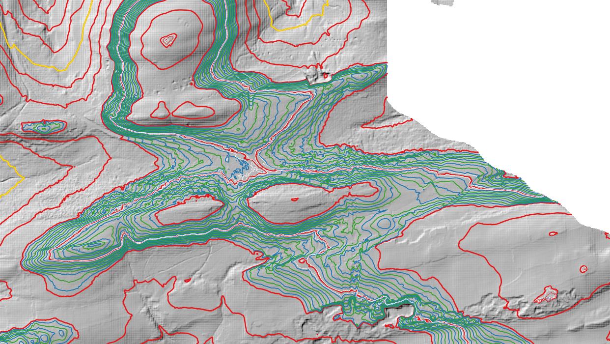


%20-%20LIDAR%20hill%202.jpg)


%20-%20LIDAR%20summit%201.jpg)
%20-%20LIDAR%20hill%201.jpg)


%20-%20LIDAR%20summit%201.jpg)


No comments:
Post a Comment